Traffic Assessment - Renfrewshire Council
Traffic Assessment - Renfrewshire Council
Traffic Assessment - Renfrewshire Council

You also want an ePaper? Increase the reach of your titles
YUMPU automatically turns print PDFs into web optimized ePapers that Google loves.
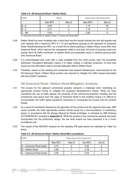
Table 4.5 A8 Greenock Road / Station Road<br />
ARM Base Base plus Development<br />
Max RFC Max Q Max RFC Max Q<br />
B - A 0.65 2 1.13 25<br />
B - C 0.71 2 1.10 11<br />
C - AB 0.52 1 0.80 5<br />
A: Greenock Road East; B: Station Road; C: Greenock Road West<br />
4.28 Station Road has been modelled with a short flare and the results indicate this arm will operate well<br />
over capacity with a maximum RFC of 1.13 and significant queuing on the approach to Greenock<br />
Road. Notwithstanding the RFC, as a result the on-street parking on Station Road, some 60m from<br />
Greenock Road, which reduces the carriageway width to one lane, this level of queuing could very<br />
quickly block all traffic movement on Station Road and potentially result in vehicles queuing back<br />
onto Greenock Road.<br />
4.29 It is acknowledged that, even with a route available from the north access road, the household<br />
distribution throughout Bishopton means it is highly unlikely a sufficient proportion of local trips<br />
would use this alternative route to provide adequate relief to Station Road.<br />
4.30 Therefore, based on the existing and consented road network infrastructure, improvements to the<br />
A8 Greenock Road / Station Road junction are required to mitigate the traffic impact associated<br />
with the 6,000m 2 foodstore.<br />
A8 Greenock Road / Station Road Mitigation Analysis<br />
4.31 The access for the adjacent commercial property presents a challenge when identifying an<br />
appropriate junction format to mitigate the proposed development’s impact. While we have<br />
considered the use of traffic signals, the proximity of the commercial property’s building and the<br />
constrained road space from the edge of Greenock Road to this building means it is difficult to<br />
accommodate the traffic signal equipment necessary to incorporate the access into the junction<br />
design.<br />
4.32 As a result of constraints imposed by the geometry of the junction and the adjacent land uses, JMP<br />
would consider the most appropriate junction format would be a mini-roundabout. A preliminary<br />
layout, in accordance with the Design Manual for Roads & Bridges, is indicated by JMP Drawing<br />
SCT3526/SR/001 provided in Appendix H. While the access to the commercial property has been<br />
incorporated into the preliminary design, the low level means we have assessed it as a 3-arm<br />
roundabout only.<br />
4.33 The results of the ARCADY analysis for the weekday PM peak period are indicated by Table 4.6<br />
below.<br />
Table 4.6 A8 Greenock Road / Station Road Mini-roundabout<br />
ARM Base plus Development<br />
Max RFC Max Q Ave RFC Ave Q<br />
A – Greenock Road (east) 0.70 2 0.63 2<br />
B – Station Road 0.90 7 0.78 4<br />
C – Greenock Road (west) 0.50 1 0.44 1<br />
Page Job No Report No Issue no Report Name<br />
22 SCT3526 1 1 Dargavel Village<br />
Proposed Village Core Development