Baltic Sea
Baltic Sea
Baltic Sea

Create successful ePaper yourself
Turn your PDF publications into a flip-book with our unique Google optimized e-Paper software.
58 o N<br />
190<br />
230 210<br />
100<br />
75<br />
100<br />
100<br />
75<br />
75<br />
30’<br />
57 o N<br />
190 210 230<br />
100<br />
250<br />
50<br />
75<br />
100<br />
100<br />
50<br />
100<br />
170<br />
271<br />
SW<br />
170<br />
230<br />
150<br />
170<br />
190<br />
NE<br />
SE<br />
50<br />
50<br />
50<br />
170<br />
75<br />
150<br />
150<br />
Latitude (deg)<br />
30’<br />
210 230 190 100<br />
75<br />
50<br />
100<br />
75<br />
100<br />
50<br />
56 o N<br />
250<br />
55 o N<br />
170<br />
30’<br />
222<br />
30’<br />
75<br />
100 190 230 210<br />
250<br />
150<br />
150150<br />
50<br />
17 o E<br />
75<br />
75<br />
50<br />
SFN<br />
SFS<br />
18 o E<br />
75<br />
50<br />
75<br />
100<br />
19 o E<br />
100<br />
50<br />
75<br />
75<br />
20 o E<br />
12 o E 16 o E 20 o E 24 o E 28 o E<br />
50<br />
EGB<br />
21 o E<br />
66 o N<br />
63 o N<br />
60 o N<br />
57 o N<br />
54 o N<br />
Longitude (deg)<br />
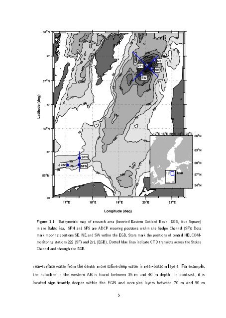
Figure 1.1: Bathymetric map of research area (inserted Eastern Gotland Basin, EGB, blue Square)<br />
in the <strong>Baltic</strong> <strong>Sea</strong>. SFN and SFS are ADCP mooring positions within the Stolpe Channel (SF); Dots<br />
mark mooring positions SE, NE and SW within the EGB. Stars mark the positions of central HELCOMmonitoring<br />
stations 222 (SF) and 271 (EGB). Dotted blue lines indicate CTD transects across the Stolpe<br />
Channel and through the EGB.<br />
near-surface water from the dense, more saline deep water in near-bottom layers. For example,<br />
the halocline in the western AB is found between 35 m and 40 m depth. In contrast, it is<br />
located signicantly deeper within the EGB and occupies layers between 70 m and 90 m<br />
5