Baltic Sea
Baltic Sea
Baltic Sea

You also want an ePaper? Increase the reach of your titles
YUMPU automatically turns print PDFs into web optimized ePapers that Google loves.
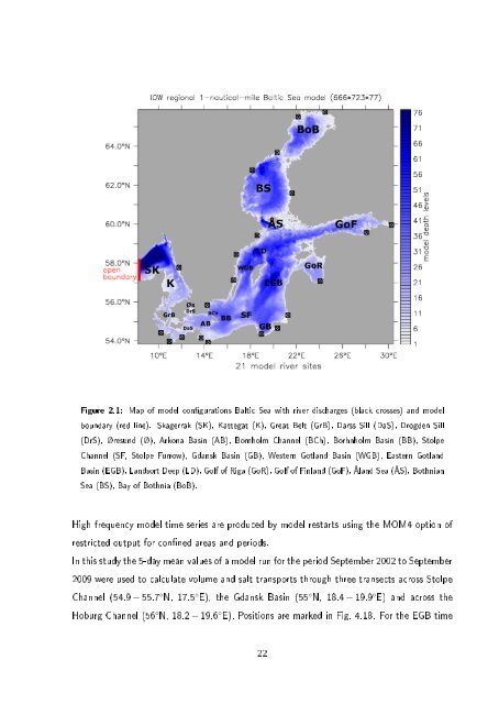
Figure 2.1: Map of model congurations <strong>Baltic</strong> <strong>Sea</strong> with river discharges (black crosses) and model<br />
boundary (red line). Skagerrak (SK), Kattegat (K), Great Belt (GrB), Darss Sill (DaS), Drogden Sill<br />
(DrS), Øresund (Ø), Arkona Basin (AB), Bornholm Channel (BCh), Borhnholm Basin (BB), Stolpe<br />
Channel (SF, Stolpe Furrow), Gdansk Basin (GB), Western Gotland Basin (WGB), Eastern Gotland<br />
Basin (EGB), Landsort Deep (LD), Golf of Riga (GoR), Golf of Finland (GoF), Åland <strong>Sea</strong> (ÅS), Bothnian<br />
<strong>Sea</strong> (BS), Bay of Bothnia (BoB).<br />
High frequency model time series are produced by model restarts using the MOM4 option of<br />
restricted output for conned areas and periods.<br />
In this study the 5-day mean values of a model run for the period September 2002 to September<br />
2009 were used to calculate volume and salt transports through three transects across Stolpe<br />
Channel (54.9 − 55.7 ◦ N, 17.5 ◦ E), the Gdansk Basin (55 ◦ N, 18.4 − 19.9 ◦ E) and across the<br />
Hoburg Channel (56 ◦ N, 18.2 − 19.6 ◦ E). Positions are marked in Fig. 4.18. For the EGB time<br />
22