Baltic Sea
Baltic Sea
Baltic Sea

You also want an ePaper? Increase the reach of your titles
YUMPU automatically turns print PDFs into web optimized ePapers that Google loves.
corresponds exactly to the deployment period of the current meter moorings in the EGB (red<br />
curve), highlighted in black is the three months deployment period of the ADCPs in the Stolpe<br />
Channel, all part of the RAGO project. The following features can be observed in the inset<br />
picture of Fig. 4.17, a strong decrease in salinity between 1 − 6 November 2006 followed by<br />
a stagnation period with a slight rise in the salt content for the rest of the month. It can be<br />
assumed that this is the small inow observed in the CTD records of the monitoring station<br />
BMP271 and inferred from the three temperature sensors of the current meter moorings.<br />
Thereafter the general trend is a decrease in salt until end of the measuring period (end of<br />
March 2007). The temperature increase recorded by the mid and lower temperature sensor<br />
(205 and 220 m) of mooring SE (compare Fig. 4.4) conrms the assumption of a new deep<br />
inow. The red curve in the inset picture shows two more occasions when the salt content<br />
remains stable and does not decrease continuously, rst the beginning of January 2007 and<br />
second during the mid of February 2007.<br />
The increase in salinity during the inow 2003 amounts to 35,000,000 tons of salt in the EGB<br />
and had its maximum at 1.09 × 10 9 tons salt (1.09 Gt salt) which decreased continuously<br />
until the beginning of April 2007. During the deployment period between May 2006 and end<br />
of March 2007 the decrease in salt amounted to 5,000,000 tons.<br />
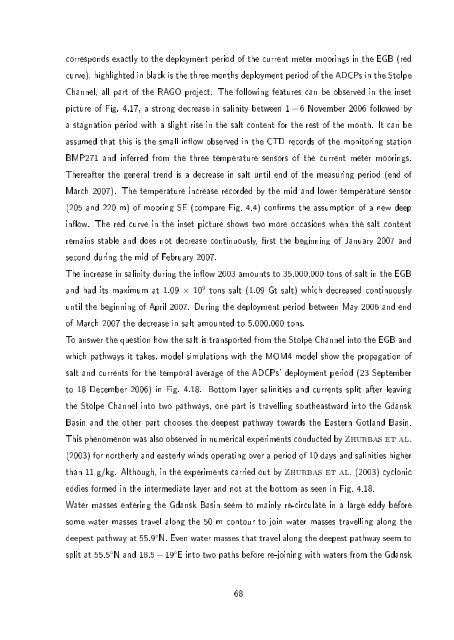
To answer the question how the salt is transported from the Stolpe Channel into the EGB and<br />
which pathways it takes, model simulations with the MOM4 model show the propagation of<br />
salt and currents for the temporal average of the ADCPs' deployment period (23 September<br />
to 18 December 2006) in Fig. 4.18. Bottom layer salinities and currents split after leaving<br />
the Stolpe Channel into two pathways, one part is travelling southeastward into the Gdansk<br />
Basin and the other part chooses the deepest pathway towards the Eastern Gotland Basin.<br />
This phenomenon was also observed in numerical experiments conducted by Zhurbas et al.<br />
(2003) for northerly and easterly winds operating over a period of 10 days and salinities higher<br />
than 11 g/kg. Although, in the experiments carried out by Zhurbas et al. (2003) cyclonic<br />
eddies formed in the intermediate layer and not at the bottom as seen in Fig. 4.18.<br />
Water masses entering the Gdansk Basin seem to mainly re-circulate in a large eddy before<br />
some water masses travel along the 50 m contour to join water masses travelling along the<br />
deepest pathway at 55.9 ◦ N. Even water masses that travel along the deepest pathway seem to<br />
split at 55.5 ◦ N and 18.5 − 19 ◦ E into two paths before re-joining with waters from the Gdansk<br />
68