

NEW_Accomplishments.indd - IRIS
NEW_Accomplishments.indd - IRIS
NEW_Accomplishments.indd - IRIS

You also want an ePaper? Increase the reach of your titles
YUMPU automatically turns print PDFs into web optimized ePapers that Google loves.
SURFACE OF THE EARTH: GLOBAL STUDIES<br />
2006 <strong>IRIS</strong> 5-YEAR PROPOSAL<br />
PASSCAL Experiments in Central Europe Target Lithospheric Structure<br />
G. Randy Keller, Kate C. Miller • University of Texas at El Paso<br />
Marek Grad • University of Warsaw, Poland<br />
Alexander Guterch • Polish Academy of Science<br />
Central Europe has experienced a complex tectonic history that dominated by<br />
the accretion of terranes to the rifted margin of Baltica that extends through central<br />
Poland (TESZ – Trans European Suture Zone) and formation of the Alps, Carpathians,<br />
and Pannonian basin (Figure 1). Beginning in 1997, Central Europe has been<br />
covered by an unprecedented network of seismic refraction experiments (Figure 2).<br />
These experiments (POLONAISEʼ97, CELEBRATION 2002, ALP2002, and SUDE-<br />
TES 2003) have only been possible due a massive international cooperative effort.<br />
They along with the BOHEMA and ALPASS teleseismic experiments are providing<br />
exciting new insights into<br />
the structure and evolution<br />
of the lithosphere in this<br />
complex region.<br />
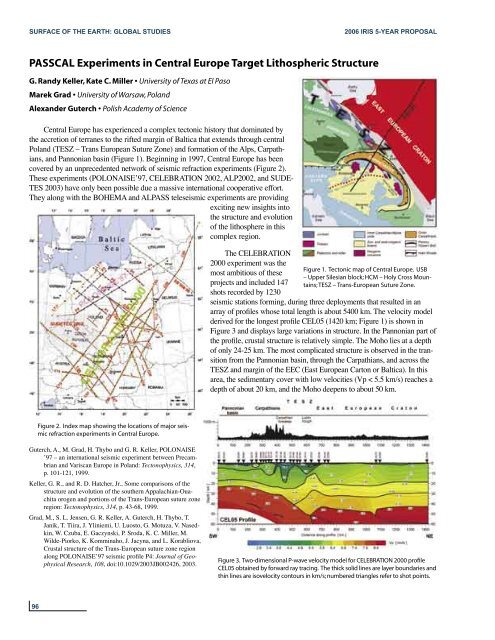
The CELEBRATION<br />
2000 experiment was the<br />
most ambitious of these<br />
projects and included 147<br />
shots recorded by 1230<br />
Figure 1. Tectonic map of Central Europe. USB<br />
– Upper Silesian block; HCM – Holy Cross Mountains;<br />
TESZ – Trans-European Suture Zone.<br />
seismic stations forming, during three deployments that resulted in an<br />
array of profiles whose total length is about 5400 km. The velocity model<br />
derived for the longest profile CEL05 (1420 km; Figure 1) is shown in<br />
Figure 3 and displays large variations in structure. In the Pannonian part of<br />
the profile, crustal structure is relatively simple. The Moho lies at a depth<br />
of only 24-25 km. The most complicated structure is observed in the transition<br />
from the Pannonian basin, through the Carpathians, and across the<br />
TESZ and margin of the EEC (East European Carton or Baltica). In this<br />
area, the sedimentary cover with low velocities (Vp < 5.5 km/s) reaches a<br />
depth of about 20 km, and the Moho deepens to about 50 km.<br />
Figure 2. Index map showing the locations of major seismic<br />
refraction experiments in Central Europe.<br />
Guterch, A., M. Grad, H. Thybo and G. R. Keller, POLONAISE<br />
ʼ97 – an international seismic experiment between Precambrian<br />
and Variscan Europe in Poland: Tectonophysics, 314,<br />
p. 101-121, 1999.<br />
Keller, G. R., and R. D. Hatcher, Jr., Some comparisons of the<br />
structure and evolution of the southern Appalachian-Ouachita<br />
orogen and portions of the Trans-European suture zone<br />
region: Tectonophysics, 314, p. 43-68, 1999.<br />
Grad, M., S. L. Jensen, G. R. Keller, A. Guterch, H. Thybo, T.<br />
Janik, T. Tiira, J. Yliniemi, U. Luosto, G. Motuza, V. Nasedkin,<br />
W. Czuba, E. Gaczynski, P. Sroda, K. C. Miller, M.<br />
Wilde-Piorko, K. Komminaho, J. Jacyna, and L. Korabliova,<br />
Crustal structure of the Trans-European suture zone region<br />
along POLONAISEʼ97 seismic profile P4: Journal of Geophysical<br />
Research, 108, doi:10.1029/2003JB002426, 2003.<br />
Figure 3. Two-dimensional P-wave velocity model for CELEBRATION 2000 profile<br />
CEL05 obtained by forward ray tracing. The thick solid lines are layer boundaries and<br />
thin lines are isovelocity contours in km/s; numbered triangles refer to shot points.<br />
96


