

NEW_Accomplishments.indd - IRIS
NEW_Accomplishments.indd - IRIS
NEW_Accomplishments.indd - IRIS

You also want an ePaper? Increase the reach of your titles
YUMPU automatically turns print PDFs into web optimized ePapers that Google loves.
SURFACE OF THE EARTH: NORTH AMERICA<br />
2006 <strong>IRIS</strong> 5-YEAR PROPOSAL<br />
Lithospheric Structure of the Rio Grande Rift<br />
The RISTRA Group<br />
The seismic structure of the crust and upper mantle of the southwestern United States has been examined using teleseismic<br />
arrivals recorded by <strong>IRIS</strong> PASSCAL Instruments in LA RISTRA (Colorado PLAteau Rio Grande Rift-Great Plains Seismic<br />
TRAnsect). Receiver function estimation and filtering methods developed by Wilson and Aster (2005) produce receiver<br />
functions with decreased sensitivity to noise. Crustal thickness and V P /V S are estimated using both direct and reverberated<br />
P-to-S receiver function modes. Regularized receiver function migration methods produce a multiple- suppressed image of<br />
the velocity discontinuity structure of the subsurface. Crustal thickness averages 44.1 +/- 2.3 km beneath the Great Plains<br />
(GP) and 45.6 +/- 1.1 km beneath the Colorado plateau (CP). Crustal thinning beneath the RGR is broadly symmetric about<br />
the <br />
beneath the RGR (figure 2). We observe a prominent northwest-dipping discontinuity, ranging from 65-85 km deep beneath<br />
the CP, and possible subcrustal discontinuities beneath the GP. These discontinuities, along with recent xenolith data, are<br />
consistent with preserved ancient lithospheric structures such as<br />
relict suture zones associated with Proterozoic subduction. An<br />
upper mantle discontinuity at 220-300 km depth may correlate<br />
with similar structure observed beneath eastern North America.<br />
Flat discontinuities at 410 and 660 km depth suggest that there<br />
is not a large-scale thermal anomaly beneath the RGR at these<br />
depths (Wilson et al., 2005b). Research supported by the NSF<br />
Geophysics program and Los Alamos IGPP; instruments and field<br />
support provided by <strong>IRIS</strong> PASSCAL.<br />
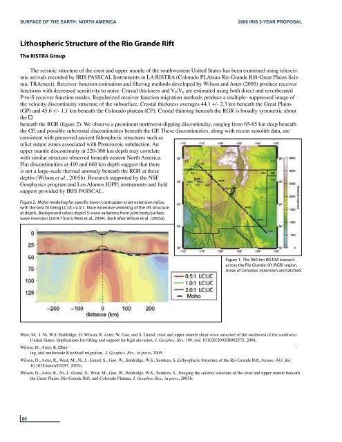
Figure 2. Moho modeling for specific lower-crust:upper-crust extension ratios,<br />
with the best fit being LC:UC=2.0:1. Note extensive widening of the rift structure<br />
at depth. Background colors depict S-wave variations from joint body/surface<br />
wave inversion (3.6-4.7 km/s; West et al., 2004). Both after Wilson et al. (2005a).<br />
Figure 1. The 960-km RISTRA transect<br />
across the Rio Grande rift (RGR) region.<br />
Areas of Cenozoic extension are hatched.<br />
West, M., J. Ni, W.S. Baldridge, D. Wilson, R. Aster, W. Gao, and S. Grand, crust and upper mantle shear wave structure of the southwest of the southwest<br />
United States: Implications for rifting and support for high elevation. J. Geophys. Res. 109, doi: 101029/2003JB002575, 2004.<br />
Wilson, D., Aster, R.,lter -<br />
ing, and multimode Kirchhoff migration, J. Geophys. Res., in press, 2005.<br />
Wilson, D., Aster, R., West, M., Ni, J., Grand, S., Gao, W., Baldridge, W.S., Semken, S.,Lithospheric Structure of the Rio Grande Rift, Nature, 433, doi:<br />
10.1038/nature03297, 2005a.<br />
Wilson, D., Aster, R., Ni, J., Grand, S., West, M., Gao, W., Baldridge, W.S., Semken, S., Imaging the seismic structure of the crust and upper mantle beneath<br />
the Great Plains, Rio Grande Rift, and Colorado Plateau, J. Geophys. Res., in press, 2005b.<br />
80


