

NEW_Accomplishments.indd - IRIS
NEW_Accomplishments.indd - IRIS
NEW_Accomplishments.indd - IRIS

Create successful ePaper yourself
Turn your PDF publications into a flip-book with our unique Google optimized e-Paper software.
2006 <strong>IRIS</strong> 5-YEAR PROPOSAL SURFACE OF THE EARTH: NORTH AMERICA<br />
A Simple Approach for the Joint Tomographic Inversion of Seismic Body<br />
and Surface Waves.<br />
Michael West • University of Alaska, Fairbanks<br />
Wei Gao, Stephen Grand • University of Texas, Austin<br />
Body and surface wave tomography have complementary strengths when applied to regional-scale studies of the upper<br />
mantle. We have derived a straight-forward technique for their joint inversion which hinges on treating surface waves as horizontally-propagating<br />
rays with deep sensitivity kernels. This formulation allows surface wave measurements to be integrated<br />
directly into existing body wave tomography inversions with modest effort. To demonstrate the method, we use data from an<br />
<strong>IRIS</strong>/PASSCAL seismic array crossing 950 km of the Southwest U.S. The dense station spacing and linear array design of the<br />
RISTRA project provide a uniquely high-quality dataset<br />
suitable for both types of tomography, as well as receiver<br />
function migration. For large arrays, this method offers an<br />
improvement over the standard approach of augmenting<br />
body wave tomography with a one-dimensional model<br />
derived from surface waves. The joint inversion combines<br />
the absolute velocity of a surface wave model with the<br />
High-Resolution afforded by body waves—both qualities<br />
that are required to understand regional-scale mantle<br />
phenomena.<br />
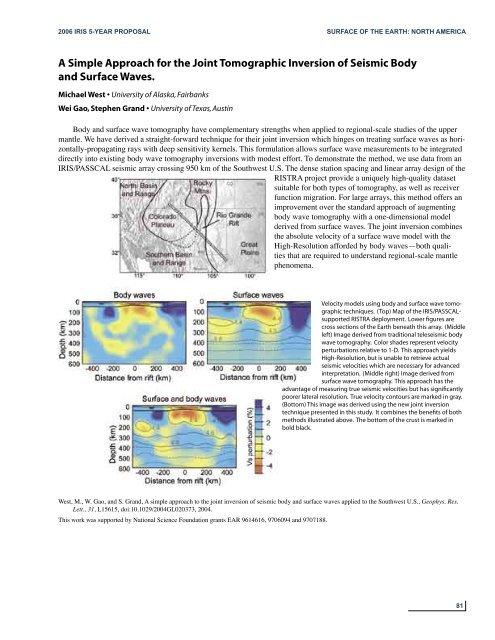
Velocity models using body and surface wave tomographic<br />
techniques. (Top) Map of the <strong>IRIS</strong>/PASSCALsupported<br />
RISTRA deployment. Lower figures are<br />
cross sections of the Earth beneath this array. (Middle<br />
left) Image derived from traditional teleseismic body<br />
wave tomography. Color shades represent velocity<br />
perturbations relative to 1-D. This approach yields<br />
High-Resolution, but is unable to retrieve actual<br />
seismic velocities which are necessary for advanced<br />
interpretation. (Middle right) Image derived from<br />
surface wave tomography. This approach has the<br />
advantage of measuring true seismic velocities but has significantly<br />
poorer lateral resolution. True velocity contours are marked in gray.<br />
(Bottom) This image was derived using the new joint inversion<br />
technique presented in this study. It combines the benefits of both<br />
methods illustrated above. The bottom of the crust is marked in<br />
bold black.<br />
West, M., W. Gao, and S. Grand, A simple approach to the joint inversion of seismic body and surface waves applied to the Southwest U.S., Geophys. Res.<br />
Lett., 31, L15615, doi:10.1029/2004GL020373, 2004.<br />
This work was supported by National Science Foundation grants EAR 9614616, 9706094 and 9707188.<br />
81


