

NEW_Accomplishments.indd - IRIS
NEW_Accomplishments.indd - IRIS
NEW_Accomplishments.indd - IRIS

You also want an ePaper? Increase the reach of your titles
YUMPU automatically turns print PDFs into web optimized ePapers that Google loves.
2006 <strong>IRIS</strong> 5-YEAR PROPOSAL SURFACE OF THE EARTH: GLOBAL STUDIES<br />
Seismic Imaging of the Himalayan Collision Zone<br />
Sheehan, Anne F., Vera Schulte-Pelkum, Gaspar Monsalve, Tom de la Torre • University of Colorado at Boulder<br />
Francis Wu • SUNY Binghamton<br />
The Himalayan Nepal Tibet PASSCAL Seismic Experiment (HIMNT) included the deployment of 28 broadband seismometers<br />
throughout eastern Nepal and southern Tibet in order to better understand the mountain building processes of this<br />
region. Our new images from receiver functions and tomography show evidence<br />
of the basal decollement of the Himalaya and an increase in Moho depth from<br />
45 km beneath Nepal to 75 km beneath Tibet. We find strong seismic anisotropy<br />
above the decollement, which may develop in response to shear processes taken<br />
up as slip in great earthquakes at shallower depths. Many local earthquakes<br />
were recorded during the deployment, and the large contrast in crustal thickness<br />
and velocity structure over a small lateral distance makes the use of a 3D<br />
velocity model important to determine accurate hypocenters. Seismicity shows<br />
strong alignment of shallow (15-25 km depth) events beneath the region<br />
of highest relief along the Himalayan Front, and a cluster of upper<br />
mantle earthquakes beneath southern Tibet (70-90 km depth).<br />
The upper mantle earthquakes are not expected by<br />
weak-mantle models. Focal mechanisms of<br />
these upper mantle earthquakes are almost<br />
all strike-slip, markedly different from the<br />
normal faulting mechanisms observed for<br />
earthquakes in the mid and upper crust beneath<br />
Tibet. This change in the orientation of<br />
the major horizontal compression axis from<br />
vertical in the upper crust to horizontal in<br />
the upper mantle suggests a transition from<br />
deformation driven by body forces in the<br />
crust to plate boundary forces in the upper<br />
mantle. Several lines of evidence point to a<br />
decoupling zone in the Tibetan mid or lower<br />
crust, which may be related to the presence<br />
of a previously suggested flow channel in the<br />
Tibetan mid crust. Surface wave tomography<br />
results reveal a strong east-west lithospheric<br />
thickness variation across the Himalayan<br />
arc, with thicker lithosphere to the west of<br />
Kathmandu and thinner to the east. This<br />
lithospheric thickness variation seems to<br />
affect the nature of subduction across the<br />
Himalayan arc, and likely has implications<br />
for seismogenesis and the strength of the<br />
lithosphere. Our preliminary results indicate<br />
that upper mantle depth Tibetan earthquakes<br />
are only found in the regions with thinner<br />
lithosphere.<br />
b<br />
85<br />
SAGA<br />
Tibetan Plateau<br />
(Tethyan<br />
Himalaya)<br />
85<br />
86<br />
86<br />
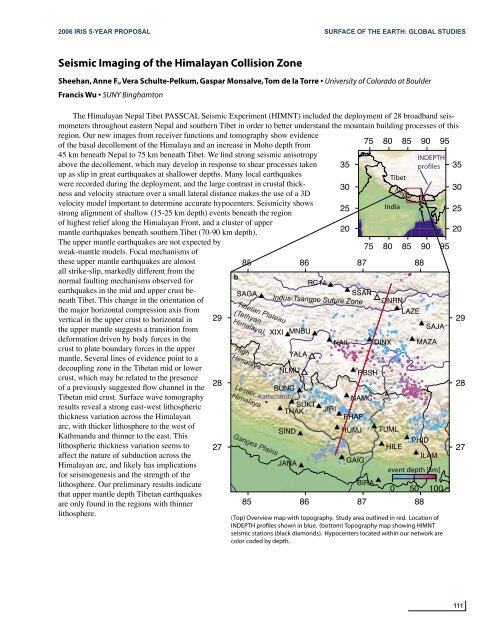
(Top) Figure Overview 1 map with topography. Study area outlined in red. Location of<br />
INDEPTH profiles shown in blue. (bottom) Topography map showing HIMNT<br />
seismic stations (black diamonds). Hypocenters located within our network are<br />
color coded by depth.<br />
75<br />
75<br />
80<br />
80<br />
85<br />
85<br />
90<br />
90<br />
95<br />
a<br />
INDEPTH<br />
35 profiles 35<br />
Tibet<br />
30 30<br />
25 India<br />
25<br />
20 20<br />
LAZE<br />
29 29<br />
SAJA<br />
XIXI MNBU<br />
NAIL DINX MAZA<br />
High<br />
Himalaya<br />
YALA<br />
RC14<br />
NLMU<br />
RBSH<br />
28<br />
BUNG<br />
28<br />
Kathmandu<br />
NAMC<br />
SUKT<br />
THAK JIRI<br />
PHAP<br />
Lesser<br />
Himalaya<br />
SIND<br />
RUMJ TUML<br />
PHID<br />
27 HILE<br />
27<br />
ILAM<br />
JANA<br />
GAIG<br />
event depth [km]<br />
Ganges Plains<br />
87<br />
SSAN<br />
Indus-Tsangpo Suture Zone<br />
BIRA<br />
87<br />
Nepal<br />
ONRN<br />
88<br />
0 50 100<br />
88<br />
95<br />
111


