

NEW_Accomplishments.indd - IRIS
NEW_Accomplishments.indd - IRIS
NEW_Accomplishments.indd - IRIS

You also want an ePaper? Increase the reach of your titles
YUMPU automatically turns print PDFs into web optimized ePapers that Google loves.
SCIENCE SUMMARIES<br />
2006 <strong>IRIS</strong> 5-YEAR PROPOSAL<br />
Investigating Earth’s Dynamic Mantle and Core<br />
Edward J. Garnero • Arizona State University<br />
Seismologists have long sought to decipher the Earthʼs inaccessible and enigmatic interior through detailed interrogation<br />
of deeply penetrating seismic energy. As we approach the 100th anniversary of the discovery of Earthʼs core, we are<br />
rapidly moving beyond the characterization of Earthʼs first-order radial stratification that dominated the decades that followed<br />
detection of the core. In fact, an explosion in the availability of broadband data from a variety of agencies and organizations<br />
over the last decade has permitted both global and regional analyses of the interior at unprecedented spatial detail. Conclusions<br />
using the remote sensing tool of seismology now regularly reach well beyond solution models of Earthʼs internal elastic<br />
structure, and extend to the characterization of Earthʼs dynamic, thermal, and chemical states (Figure 1). Advancements in<br />
our understanding of the interior have been primarily and fundamentally facilitated through the efforts and successes of the<br />
<strong>IRIS</strong> mission. Data are now easily available through a variety of method, to anyone in the world.<br />
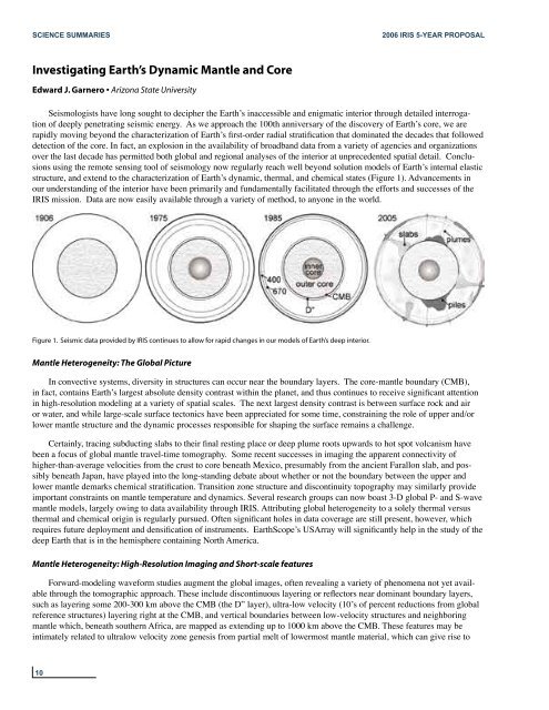
Figure 1. Seismic data provided by <strong>IRIS</strong> continues to allow for rapid changes in our models of Earth’s deep interior.<br />
Mantle Heterogeneity: The Global Picture<br />
In convective systems, diversity in structures can occur near the boundary layers. The core-mantle boundary (CMB),<br />
in fact, contains Earthʼs largest absolute density contrast within the planet, and thus continues to receive significant attention<br />
in high-resolution modeling at a variety of spatial scales. The next largest density contrast is between surface rock and air<br />
or water, and while large-scale surface tectonics have been appreciated for some time, constraining the role of upper and/or<br />
lower mantle structure and the dynamic processes responsible for shaping the surface remains a challenge.<br />
Certainly, tracing subducting slabs to their final resting place or deep plume roots upwards to hot spot volcanism have<br />
been a focus of global mantle travel-time tomography. Some recent successes in imaging the apparent connectivity of<br />
higher-than-average velocities from the crust to core beneath Mexico, presumably from the ancient Farallon slab, and possibly<br />
beneath Japan, have played into the long-standing debate about whether or not the boundary between the upper and<br />
lower mantle demarks chemical stratification. Transition zone structure and discontinuity topography may similarly provide<br />
important constraints on mantle temperature and dynamics. Several research groups can now boast 3-D global P- and S-wave<br />
mantle models, largely owing to data availability through <strong>IRIS</strong>. Attributing global heterogeneity to a solely thermal versus<br />
thermal and chemical origin is regularly pursued. Often significant holes in data coverage are still present, however, which<br />
requires future deployment and densification of instruments. EarthScopeʼs USArray will significantly help in the study of the<br />
deep Earth that is in the hemisphere containing North America.<br />
Mantle Heterogeneity: High-Resolution Imaging and Short-scale features<br />
Forward-modeling waveform studies augment the global images, often revealing a variety of phenomena not yet available<br />
through the tomographic approach. These include discontinuous layering or reflectors near dominant boundary layers,<br />
such as layering some 200-300 km above the CMB (the D” layer), ultra-low velocity (10ʼs of percent reductions from global<br />
reference structures) layering right at the CMB, and vertical boundaries between low-velocity structures and neighboring<br />
mantle which, beneath southern Africa, are mapped as extending up to 1000 km above the CMB. These features may be<br />
intimately related to ultralow velocity zone genesis from partial melt of lowermost mantle material, which can give rise to<br />
10


