

NEW_Accomplishments.indd - IRIS
NEW_Accomplishments.indd - IRIS
NEW_Accomplishments.indd - IRIS

You also want an ePaper? Increase the reach of your titles
YUMPU automatically turns print PDFs into web optimized ePapers that Google loves.
SURFACE OF THE EARTH: NORTH AMERICA<br />
2006 <strong>IRIS</strong> 5-YEAR PROPOSAL<br />
High-Resolution Surface Wave Tomography From Ambient Seismic Noise<br />
Nikolai M. Shapiro, Michael H. Ritzwoller • University of Colorado at Boulder<br />
Michel Campillo, Laurent Stehly • Laboratoire de Géophysique Interne et de Tectonophysique Université Joseph Fourier,<br />
Grenoble, France<br />
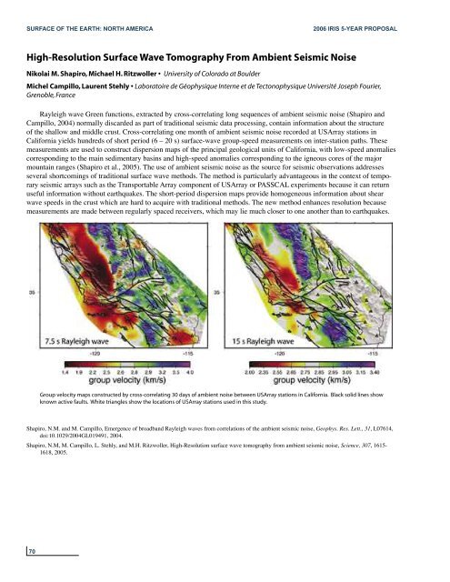
Rayleigh wave Green functions, extracted by cross-correlating long sequences of ambient seismic noise (Shapiro and<br />
Campillo, 2004) normally discarded as part of traditional seismic data processing, contain information about the structure<br />
of the shallow and middle crust. Cross-correlating one month of ambient seismic noise recorded at USArray stations in<br />
California yields hundreds of short period (6 – 20 s) surface-wave group-speed measurements on inter-station paths. These<br />
measurements are used to construct dispersion maps of the principal geological units of California, with low-speed anomalies<br />
corresponding to the main sedimentary basins and high-speed anomalies corresponding to the igneous cores of the major<br />
mountain ranges (Shapiro et al., 2005). The use of ambient seismic noise as the source for seismic observations addresses<br />
several shortcomings of traditional surface wave methods. The method is particularly advantageous in the context of temporary<br />
seismic arrays such as the Transportable Array component of USArray or PASSCAL experiments because it can return<br />
useful information without earthquakes. The short-period dispersion maps provide homogeneous information about shear<br />
wave speeds in the crust which are hard to acquire with traditional methods. The new method enhances resolution because<br />
measurements are made between regularly spaced receivers, which may lie much closer to one another than to earthquakes.<br />
Group velocity maps constructed by cross-correlating 30 days of ambient noise between USArray stations in California. Black solid lines show<br />
known active faults. White triangles show the locations of USArray stations used in this study.<br />
Shapiro, N.M. and M. Campillo, Emergence of broadband Rayleigh waves from correlations of the ambient seismic noise, Geophys. Res. Lett., 31, L07614,<br />
doi:10.1029/2004GL019491, 2004.<br />
Shapiro, N.M, M. Campillo, L. Stehly, and M.H. Ritzwoller, High-Resolution surface wave tomography from ambient seismic noise, Science, 307, 1615-<br />
1618, 2005.<br />
70


