

NEW_Accomplishments.indd - IRIS
NEW_Accomplishments.indd - IRIS
NEW_Accomplishments.indd - IRIS

You also want an ePaper? Increase the reach of your titles
YUMPU automatically turns print PDFs into web optimized ePapers that Google loves.
SIGNALS AND SYSTEMS<br />
2006 <strong>IRIS</strong> 5-YEAR PROPOSAL<br />
Passive Crustal Refraction Experiments Using <strong>IRIS</strong>/PASSCAL Facilities:<br />
New Surveys Show Variable Crustal Thickness in the Western Great Basin<br />
John N. Louie and Michelle Heimgartner • University of Nevada<br />
Utilizing commercial mine blasts and local earthquakes, as well as a dense array of portable seismographs, we have<br />
achieved long-range crustal refraction profiles across northern Nevada and the Sierra Nevada Mountains. In our most recent<br />
refraction experiment, the Idaho- Nevada-California (INC) transect, we used a dense spacing of 411 portable seismographs<br />
and 4.5-Hz geophones. The instruments were able to record events ranging from large mine blasts to small local earthquakes.<br />
Our instruments sensed blast first arrivals out to a distance of approximately 400 km. We have obtained 99% data recovery<br />
and clear refractions across the central Sierra Nevada and the northern Great Basin. The Northern Walker Lane refraction<br />
experiment, completed in 2002, confirms the presence of a thin crust ranging from 19-23 km thick in a 100 km region in the<br />
vicinity of Battle Mountain, Nevada. Pn crossover distances of less than 95 km from both the INC and Northern Walker Lane<br />
experiments support this observation. We also observe an unexpectedly deep crustal root under the northern Sierra Nevada,<br />
over 50 km in thickness and centered west of the topographic crest. In addition, we have created contoured crustal thickness<br />
maps based literature cited from previous compilations. These maps integrate our current experiments with past geophysical<br />
assessments of the Great Basin. Our seismic-refraction reconnaissance of the western Great Basin will contribute to the assessment<br />
of geothermal potential in poorly constrained areas.<br />
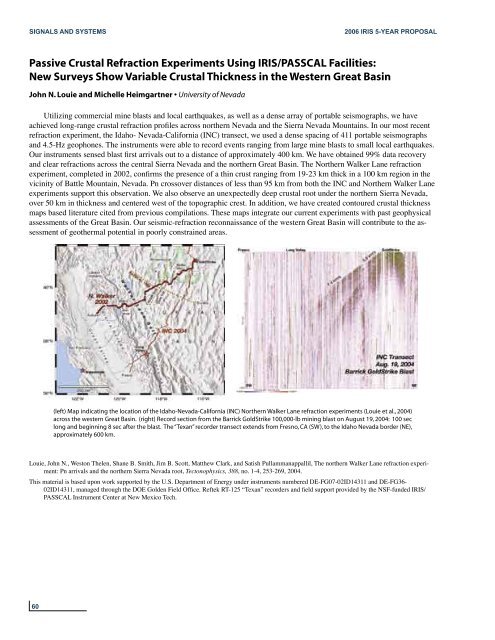
(left) Map indicating the location of the Idaho-Nevada-California (INC) Northern Walker Lane refraction experiments (Louie et al., 2004)<br />
across the western Great Basin. (right) Record section from the Barrick GoldStrike 100,000-lb mining blast on August 19, 2004: 100 sec<br />
long and beginning 8 sec after the blast. The “Texan” recorder transect extends from Fresno, CA (SW), to the Idaho Nevada border (NE),<br />
approximately 600 km.<br />
Louie, John N., Weston Thelen, Shane B. Smith, Jim B. Scott, Matthew Clark, and Satish Pullammanappallil, The northern Walker Lane refraction experiment:<br />
Pn arrivals and the northern Sierra Nevada root, Tectonophysics, 388, no. 1-4, 253-269, 2004.<br />
This material is based upon work supported by the U.S. Department of Energy under instruments numbered DE-FG07-02ID14311 and DE-FG36-<br />
02ID14311, managed through the DOE Golden Field Office. Reftek RT-125 “Texan” recorders and field support provided by the NSF-funded <strong>IRIS</strong>/<br />
PASSCAL Instrument Center at New Mexico Tech.<br />
60


