

NEW_Accomplishments.indd - IRIS
NEW_Accomplishments.indd - IRIS
NEW_Accomplishments.indd - IRIS

Create successful ePaper yourself
Turn your PDF publications into a flip-book with our unique Google optimized e-Paper software.
2006 <strong>IRIS</strong> 5-YEAR PROPOSAL SURFACE OF THE EARTH: NORTH AMERICA<br />
Imaging Upper Mantle Structure Beneath the Illinois Basin<br />
Heather Bedle, Suzan van der Lee • Northwestern University<br />
The Illinois Basin is an oval-shaped cratonic basin which covers parts of southern Illinois and Indiana, western Kentucky,<br />
Tennessee, and Missouri. The shallow structure of the Illinois Basin is well-defined and provides constraints which<br />
may allow the effects of crustal structure to be removed from seismic waveforms during tomographic inversions. We used<br />
<strong>IRIS</strong> data to test if better constraints of crustal heterogeneities will allow better resolution of the upper mantle S-velocity<br />
structure beneath the Illinois Basin. This improved imaging of the crust and the upper mantle S-velocities provides insights<br />
into the development of the basin, and addresses the issue of whether it is possible to improve seismic waveform tomography<br />
on a regional scale by incorporating crustal constraints.<br />
Fundamental and higher mode waveforms from regional events were obtained from the <strong>IRIS</strong> DMC and were then<br />
inverted to image the three-dimensional upper mantle S-velocity structure under the Illinois basin. The method of partitioned<br />
waveform inversion, PWI, (Nolet, 1990; van der Lee and Nolet, 1997) was applied to the waveforms. Utilizing six mid-continent<br />
events, a total of 60 seismograms from the <strong>IRIS</strong>/IDA Network, the <strong>IRIS</strong>/USGS Network, the Cooperative New Madrid<br />
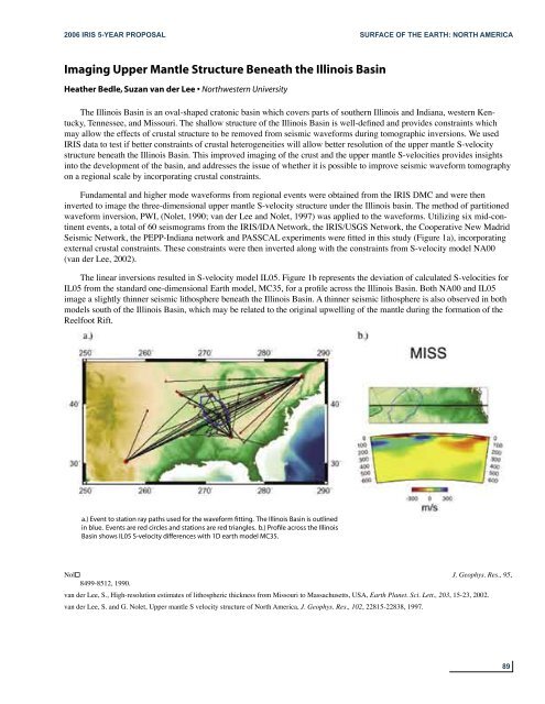
Seismic Network, the PEPP-Indiana network and PASSCAL experiments were fitted in this study (Figure 1a), incorporating<br />
external crustal constraints. These constraints were then inverted along with the constraints from S-velocity model NA00<br />
(van der Lee, 2002).<br />
The linear inversions resulted in S-velocity model IL05. Figure 1b represents the deviation of calculated S-velocities for<br />
IL05 from the standard one-dimensional Earth model, MC35, for a profile across the Illinois Basin. Both NA00 and IL05<br />
image a slightly thinner seismic lithosphere beneath the Illinois Basin. A thinner seismic lithosphere is also observed in both<br />
models south of the Illinois Basin, which may be related to the original upwelling of the mantle during the formation of the<br />
Reelfoot Rift.<br />
a.) Event to station ray paths used for the waveform fitting. The Illinois Basin is outlined<br />
in blue. Events are red circles and stations are red triangles. b.) Profile across the Illinois<br />
Basin shows IL05 S-velocity differences with 1D earth model MC35.<br />
Nol J. Geophys. Res., 95,<br />
8499-8512, 1990.<br />
van der Lee, S., High-resolution estimates of lithospheric thickness from Missouri to Massachusetts, USA, Earth Planet. Sci. Lett., 203, 15-23, 2002.<br />
van der Lee, S. and G. Nolet, Upper mantle S velocity structure of North America, J. Geophys. Res., 102, 22815-22838, 1997.<br />
89


