

NEW_Accomplishments.indd - IRIS
NEW_Accomplishments.indd - IRIS
NEW_Accomplishments.indd - IRIS

Create successful ePaper yourself
Turn your PDF publications into a flip-book with our unique Google optimized e-Paper software.
SCIENCE SUMMARIES<br />
2006 <strong>IRIS</strong> 5-YEAR PROPOSAL<br />
The Continental Lithosphere and Seismology<br />
Alan Levander, Adrian Lenardic • Rice University<br />
Karl Karlstrom • University of New Mexico<br />
The success of plate tectonics in describing the evolution of the ocean basins lies in the regular progression of oceanic<br />
lithosphere from its generation at spreading ridges to its consumption at subduction zones, and the simple description of the<br />
tectonics of oceanic lithosphere in terms of translation, rotation, and consumption of large “rigid,” nearly uniform plates<br />
obeying fairly simple geometric laws at their boundaries. This process dominates global tectonics at scales of hundreds to<br />
thousands of kilometers and durations of ~0.2 Ga and is often taken as the surface expression of mantle convection, with<br />
the crust and mantle forming the upper thermal boundary layer. Differentiation processes at ocean ridges are also relatively<br />
simple, creating plate-wide layered structures that are largely recycled by subduction, and the relationships between the age<br />
of the lithosphere, its thickness, thermal state, and density are well known.<br />
The Earth, unique among the planets, has a bimodal distribution of topography, with ~40% of its surface made up of<br />
continents, whose surfaces reside above to slightly below sea level, and ~60% oceans with average elevation of ~ - 4km.<br />
This is the most obvious difference between the continents and oceans, but there are equally profound differences extending<br />
to depths of 200-400 km first recognized seismologically almost 30 years ago. In contrast to the 60% of the Earth forming<br />
the oceanic plates, the 40% comprising the continents has grown<br />
over the last ~4.5 Ga through a complex sequence of differentiation<br />
and deformation processes that operate on scales of hundreds<br />
of kilometers and smaller, including highly localized, phenomena<br />
such as faulting and pluton emplacement. The resulting continental<br />
lithosphere consists of a complex collage of fragments of various<br />
tectonic affinities. While these fragments can be collected to form<br />
supercontinents or dispersed by the same convection system that<br />
creates and recycles oceanic plates, the development of continental<br />
lithosphere itself, unlike the oceanic lithosphere, cannot be viewed<br />
in terms of the creation of a thermal boundary layer in the convecting<br />
mantle system, and continental tectonics cannot be simply<br />
described by translation, rotation, and consumption of large, “rigid,”<br />
nearly-uniform plates obeying fairly simple geometric laws at their<br />
boundaries. In general, continental crust does<br />
not participate in global mantle overturn and this<br />
also appears to be the case for the subcontinental<br />
mantle beneath many cratons. Thus, the continental<br />
lithosphere is not a simple active upper thermal<br />
boundary layer within the convecting mantle system,<br />
and understanding the structure of continents<br />
requires understanding the cumulative products of<br />
magmatic and deformational processes that have<br />
acted over billions of years of Earthʼs history. The<br />
thickness and chemical buoyancy of continental<br />
crust makes continents resistant to subduction.<br />
That this could effect large-scale mantle dynamics<br />
was proposed almost 70 years ago by Pekeris<br />
(1935).<br />
Continents represent the products of repeated differentiation<br />
cycles whereby less-dense, intermediateto-felsic,<br />
crust is upwardly stratified by combinations<br />
of tectonomagmatic processes. Accretion of uniquely<br />
continental materials takes place above subduction zones<br />
in magmatic arcs and orogenic plateaus, but formation of<br />
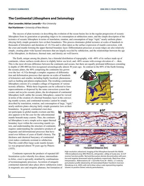
High-resolution, teleseismic imaging of the lithosphere beneath the Abitibi<br />
1996 broadband array (<strong>IRIS</strong>-PASSCAL, Lithoprobe). a)Map of study area. b) CCP<br />
receiver function profile. Red and blue pulses denote discontinuities with positive<br />
and negative downward velocity gradients, respectively. Black lines show<br />
interpretation. Abbreviations: GF = Grenville Front, M = Moho. c) S-velocity<br />
perturbation profile obtained by 2D Generalized Radon Transform inversion<br />
(Rondenay et al., 2005), with red to blue colour scale representing negative<br />
(slower) to positive (faster) velocity perturbations.<br />
6


