

NEW_Accomplishments.indd - IRIS
NEW_Accomplishments.indd - IRIS
NEW_Accomplishments.indd - IRIS

Create successful ePaper yourself
Turn your PDF publications into a flip-book with our unique Google optimized e-Paper software.
2006 <strong>IRIS</strong> 5-YEAR PROPOSAL SURFACE OF THE EARTH: NORTH AMERICA<br />
The North American Upper Mantle: Density, Composition, and Evolution<br />
Walter D. Mooney • U.S. Geological Survey, Menlo Park<br />
Misha Kaban • GeoForschungsZentrum (GFZ), Potsdam, Germany<br />
The upper mantle of North America (NA) has been well studied using various seismic methods. Here we investigate the<br />
density structure of the NA upper mantle based on the Bouguer gravity anomaly map. The basis of our study is the removal<br />
of the gravitational effect of the crust to determine the mantle gravity field. The effect of the crust is removed in three steps<br />
by subtracting the gravitational contributions of: (1) topography; (2) low-density sedimentary accumulations; and (3) the 3D<br />
density structure of the crystalline crust. Topographic data are taken from a standard data base; information regarding sedimentary<br />
accumulations, including thickness and density, are taken from published maps and summaries of borehole measurements<br />
of densities; the structure of the crust is from a recent compilation, with layer densities estimated from compressional<br />
wave velocities. The resultant mantle gravity anomaly map shows a negative anomaly (-50 to –400 mgal) beneath western<br />
NA and the adjacent oceanic region, and positive anomalies (+50 to +350 mgal) to the east of the NA Cordillera. This pattern<br />
reflects the well-known division of NA into the stable eastern portion and the tectonically active western portion. In order to<br />
separate the contributions of thermal expansion from mantle composition, we apply an additional correction for the thermal<br />
structure of the uppermost mantle. The thermally-corrected map reveals mantle density anomalies that are solely due to<br />
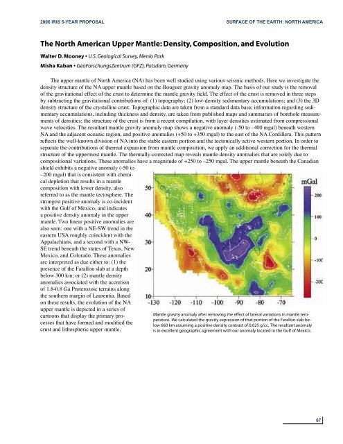
compositional variations. These anomalies have a magnitude of +250 to –250 mgal. The upper mantle beneath the Canadian<br />
shield exhibits a negative anomaly (-50 to<br />
–200 mgal) that is consistent with chemical<br />
depletion that results in a mantle<br />
composition with lower density, also<br />
referred to as the mantle tectosphere. The<br />
strongest positive anomaly is co-incident<br />
with the Gulf of Mexico, and indicates<br />
a positive density anomaly in the upper<br />
mantle. Two linear positive anomalies are<br />
also seen: one with a NE-SW trend in the<br />
eastern USA roughly coincident with the<br />
Appalachians, and a second with a NW-<br />
SE trend beneath the states of Texas, New<br />
Mexico, and Colorado. These anomalies<br />
are interpreted as due either to: (1) the<br />
presence of the Farallon slab at a depth<br />
below 300 km; or (2) mantle density<br />
anomalies associated with the accretion<br />
of 1.8-0.8 Ga Proterozoic terrains along<br />
the southern margin of Laurentia. Based<br />
on these results, the evolution of the NA<br />
upper mantle is depicted in a series of<br />
cartoons that display the primary processes<br />
that have formed and modified the<br />
crust and lithospheric upper mantle.<br />
Mantle gravity anomaly after removing the effect of lateral variations in mantle temperature.<br />
We calculated the gravity expression of that portion of the Farallon slab below<br />
660 km assuming a positive density contrast of 0.025 g/cc. The resultant anomaly<br />
is in excellent geographic agreement with our anomaly located in the Gulf of Mexico.<br />
67


