Tetra Tech, Inc
Tetra Tech, Inc
Tetra Tech, Inc

You also want an ePaper? Increase the reach of your titles
YUMPU automatically turns print PDFs into web optimized ePapers that Google loves.
Water System Master Planning,<br />
Mapping, and Modeling<br />
Bartow, Florida<br />
Relevant Project Highlights<br />
for Crestview:<br />
• 13 Years of Water Master<br />
Planning Services to this<br />
Client<br />
• 10-year Water Master<br />
Plan<br />
• Evaluated Permitting<br />
Requirements with FDEP<br />
and Water Mgmt District<br />
• Provided Hydraulic Model<br />
Training to City Staff<br />
The City of Bartow has an extensive water system. The City's water service area<br />
encompasses the entire incorporated City limits of the City of Bartow and areas of<br />
unincorporated Polk County. The City’s system is served by two well systems with<br />
permitted capacity of 7.0 MGD. The combined system storage is 2.6 MG. The City has<br />
seen consistent growth from just over 15,025 residents in 1996 to over 16,043 in 2005.<br />
It is anticipated that the City will continue to see steady growth during the next 10 years.<br />
<strong>Tetra</strong> <strong>Tech</strong> was contracted by the City to conduct an original Master Plan in 1996, and<br />
provided updates in 2007 and 2008. The master planning effort included gathering<br />
existing data, verifying existing as-built and water atlas data, creating and updating the<br />
hydraulic model in WaterCAD, master planning, CIP development, and funding<br />
review. The master plan includes permitting requirements for improvements to the<br />
water system. <strong>Tetra</strong> <strong>Tech</strong> has served the City since 1996 for master planning services.<br />
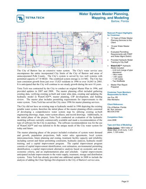
The City did not have an existing map or hydraulic model in 1996 depicting the existing<br />
potable water system, therefore the initial phase of the master planning efforts consisted<br />
of developing a comprehensive water system map by utilizing existing as-built<br />
engineering drawings, maps, water system atlases, and record drawings. Additionally, in<br />
the initial phase of the project, <strong>Tetra</strong> <strong>Tech</strong> conducted an evaluation of the hydraulic<br />
modeling software currently commercially available and made a recommendation of the<br />
type of software for the City to purchase. The software recommendation was for the use<br />
of WaterCAD and was tailored to fit the unique needs of the City water system for<br />
today and future.<br />
The master planning phase of the project included evaluation of system water demand<br />
and growth, population projections, bulk water sales agreements, local system<br />
interconnections, future planning and zoning, treatment facility capacity and reliability<br />
including current and future permitting constraints, hydraulic analysis, hydraulic model<br />
training, and a capital improvement program. The capital improvement program<br />
consists of capital improvement identification, cost estimation, environmental permitting<br />
identification, a capital improvement alternative analysis based on economic and noneconomic<br />
criteria, and an implementation plan and schedule. Capital improvements<br />
anticipated include improvements to the water supply, treatment, storage and distribution<br />
systems. <strong>Tetra</strong> <strong>Tech</strong> has already provided one additional update in 2008 to include the<br />
analysis of adding the Clear Springs Development to the City of Bartow's service area.<br />
• WaterCAD Hydraulic<br />
Model <strong>Inc</strong>luded:<br />
- 4-24 inch (range of pipe<br />
diameters)<br />
- 198.4 miles<br />
- 1,451 pipes<br />
- 1,129 nodes<br />
- Two Wellfields<br />
• Master Plan Report<br />
Prepared<br />
Crestview Team Members<br />
Responsible for Work:<br />
Jon Fox, PE<br />
Alex Montalvo<br />
Client Reference:<br />
City of Bartow, Florida<br />
Mr. Ron Johnson<br />
863.534.0159<br />
Completion Date:<br />
June 2008<br />
Type and Size of Modeling:<br />
Water System: 198.4 miles of<br />
Water Main (4-24 inch), 1,451<br />
pipes, 1,129 nodes<br />
Page 51