

Piedmont Greenway Master Plan - Town of Kernersville
Piedmont Greenway Master Plan - Town of Kernersville
Piedmont Greenway Master Plan - Town of Kernersville
- No tags were found...

Create successful ePaper yourself
Turn your PDF publications into a flip-book with our unique Google optimized e-Paper software.
whether publicly or privately owned—are dedicated for multiple uses and are normally designed to meet<br />
federal, state, and local standards for public safety.<br />
Water Quality and Water<br />
Quantity Benefits<br />
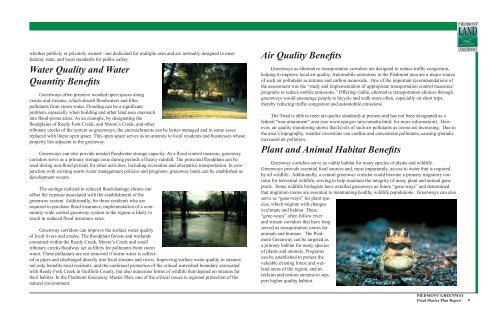
<strong>Greenway</strong>s <strong>of</strong>ten preserve wooded open spaces along<br />
creeks and streams, which absorb floodwaters and filter<br />
pollutants from storm water. Flooding can be a significant<br />
problem, especially when building and other land uses encroach<br />
into flood-prone areas. As an example, by designating the<br />
floodplains <strong>of</strong> Reedy Fork Creek, and Moore’s Creek, and other<br />
tributary creeks <strong>of</strong> the system as greenways, the encroachments can be better managed and in some cases<br />
replaced with linear open space. This open space serves as an amenity to local residents and businesses whose<br />
property lies adjacent to the greenway.<br />
<strong>Greenway</strong>s can also provide needed floodwater storage capacity. As a flood control measure, greenway<br />
corridors serve as a primary storage zone during periods <strong>of</strong> heavy rainfall. The protected floodplain can be<br />
used during non-flood periods for other activities, including recreation and alternative transportation. In conjunction<br />
with existing storm water management policies and programs, greenway lands can be established as<br />
development occurs.<br />
The savings realized in reduced flood-damage claims can<br />
<strong>of</strong>fset the expense associated with the establishment <strong>of</strong> the<br />
greenway system. Additionally, for those residents who are<br />
required to purchase flood insurance, implementation <strong>of</strong> a community-wide<br />
central greenway system in the region is likely to<br />
result in reduced flood insurance rates.<br />
<strong>Greenway</strong> corridors can improve the surface water quality<br />
<strong>of</strong> local rivers and creeks. The floodplain forests and wetlands<br />
contained within the Reedy Creek, Moore’s Creek and small<br />
tributary creeks floodway act as filters for pollutants from storm<br />
water. These pollutants are not removed if storm water is collected<br />
in pipes and discharged directly into local streams and rivers. Improving surface water quality in streams<br />
not only benefits local residents, and the continued protection <strong>of</strong> the critical watershed boundary associated<br />
with Reedy Fork Creek in Guilford County, but also numerous forms <strong>of</strong> wildlife that depend on streams for<br />
their habitat. In the <strong>Piedmont</strong> <strong>Greenway</strong> <strong>Master</strong> <strong>Plan</strong>, one <strong>of</strong> the critical issues is regional protection <strong>of</strong> the<br />
natural environment.<br />
Air Quality Benefits<br />
<strong>Greenway</strong>s as alternative transportation corridors are designed to reduce traffic congestion,<br />
helping to improve local air quality. Automobile emissions in the <strong>Piedmont</strong> area are a major source<br />
<strong>of</strong> such air pollutants as nitrates and carbon monoxide. One <strong>of</strong> the important recommendations <strong>of</strong><br />
the assessment was the “study and implementation <strong>of</strong> appropriate transportation control measures/<br />
programs to reduce mobile emissions.” Offering viable, alternative transportation choices through<br />
greenways would encourage people to bicycle and walk more <strong>of</strong>ten, especially on short trips,<br />
thereby reducing traffic congestion and automobile emissions.<br />
The Triad is able to meet air quality standards at present and has not been designated as a<br />
federal “non-attainment” area (see www.epa.gov/airs/nonattn.html, for more information). However,<br />
air quality monitoring shows that levels <strong>of</strong> such air pollutants as ozone are increasing. Due to<br />
the area’s topography, weather inversions can confine and concentrate pollutants, causing sporadic<br />
increased air pollution.<br />
<strong>Plan</strong>t and Animal Habitat Benefits<br />
<strong>Greenway</strong> corridors serve as viable habitat for many species <strong>of</strong> plants and wildlife.<br />
<strong>Greenway</strong>s provide essential food sources and, most importantly, access to water that is required<br />
by all wildlife. Additionally, a central greenway corridor could become a primary migratory corridor<br />
for terrestrial wildlife, serving to help maintain the integrity <strong>of</strong> many plant and animal gene<br />
pools. Some wildlife biologists have extolled greenways as future “gene-ways” and determined<br />
that migration routes are essential to maintaining healthy wildlife populations. <strong>Greenway</strong>s can also<br />
serve as “gene-ways” for plant species,<br />
which migrate with changes<br />
in climate and habitat. These<br />
“gene-ways” <strong>of</strong>ten follow river<br />
and stream corridors that have long<br />
served as transportation routes for<br />
animals and humans. The <strong>Piedmont</strong><br />
<strong>Greenway</strong> can be targeted as<br />
a primary habitat for many species<br />
<strong>of</strong> plants and animals. Programs<br />
can be established to protect the<br />
valuable existing forest and wetland<br />
areas <strong>of</strong> the region, and to<br />
reclaim and restore streams to support<br />
higher quality habitat.<br />
PIEDMONT GREENWAY<br />
Final <strong>Master</strong> <strong>Plan</strong> Report 9


