

Piedmont Greenway Master Plan - Town of Kernersville
Piedmont Greenway Master Plan - Town of Kernersville
Piedmont Greenway Master Plan - Town of Kernersville
- No tags were found...

Create successful ePaper yourself
Turn your PDF publications into a flip-book with our unique Google optimized e-Paper software.
with bike lanes, bike routes or streets that are frequently used by bicyclists.<br />
On diagonal railroad crossings, the flangeway can trap a bike’s front wheel causing it to divert. The<br />
end result is a quick fall for the bicyclist. This problem is most serious when the track crosses at an angle<br />
less than 45 degrees to the direction <strong>of</strong> travel. One solution is to provide a way for bicyclists to approach<br />
the track at a 60 degree angle or greater, by flaring the street. This solution allows the bicyclist to cross at a<br />
right angle without swerving into the path <strong>of</strong> passing motor vehicle traffic.<br />
Another solution is to install a commercially-available rubberized flangeway filler strip. The filler<br />
normally fills the gap between the inside railbed and the rail. When a train wheel rolls over it, the flangeway<br />
filler compresses. This solution, however, is not acceptable for high-speed rail lines, as the filler will not<br />
compress fast enough and the train may derail (North Carolina Bicycle Facility Design Guidelines, 1994).<br />
Secondary Trails<br />
Several other trail types are defined within the <strong>Master</strong> <strong>Plan</strong>. These range from natural surface footpaths<br />
to sidewalk trails. Footpaths along creeks should be maintained as natural surface trails. The only construction<br />
necessary will be the removal <strong>of</strong> stumps, fallen limbs, rocks and trash. These trails will be usable most<br />
<strong>of</strong> the time except when heavy rain have made the surface exceptionally muddy.<br />
Secondary trails also include sidewalk trails from adjacent neighborhoods and businesses to the primary<br />
trial, and signage that includes all on-road bicycle routing. Sidewalk trails are constructed from concrete<br />
or asphalt where they are missing from the existing route plan, and should be at least 6 feet wide. The<br />
additional trails should consider usage by cyclists where possible. The cyclists should be encouraged to use<br />
existing roadways and follow the appropriate signage. Some joint use <strong>of</strong> sidewalks may be necessary due to<br />
constrained roadway width.<br />
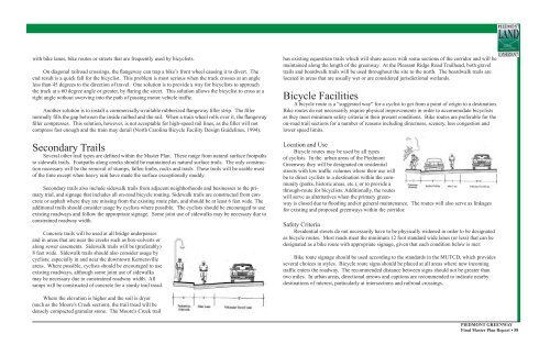
Concrete trails will be used at all bridge underpasses<br />
and in areas that are near the creeks such as box-culverts or<br />
along sewer easements. Sidewalk trails will be (preferably)<br />
8 feet wide. Sidewalk trails should also consider usage by<br />
cyclists; especially in and near the downtown <strong>Kernersville</strong><br />
areas. Where possible, cyclists should be encouraged to use<br />
existing roadways, although some joint use <strong>of</strong> sidewalks<br />
may be necessary due to constrained roadway width. All<br />
ramps will be constructed <strong>of</strong> concrete for a sturdy trail tread.<br />
has existing equestrian trails which will share access with some sections <strong>of</strong> the corridor and will be<br />
maintained along the length <strong>of</strong> the greenway. At the Pleasant Ridge Road Trailhead, both gravel<br />
trails and boardwalk trails will be used throughout the site to the north. The boardwalk trails are<br />
located in areas that are usually wet or are considered jurisdictional wetlands.<br />
Bicycle Facilities<br />
A bicycle route is a “suggested way” for a cyclist to get from a point <strong>of</strong> origin to a destination.<br />
Bike routes do not necessarily require physical improvements in order to accommodate bicyclists<br />
as they meet minimum safety criteria in their present conditions. Bike routes are preferable for the<br />
on-road trail sections for a number <strong>of</strong> reasons including directness, scenery, less congestion and<br />
lower speed limits.<br />
Location and Use<br />
Bicycle routes may be used by all types<br />
<strong>of</strong> cyclists. In the urban areas <strong>of</strong> the <strong>Piedmont</strong><br />
<strong>Greenway</strong> they will be designated on residential<br />
streets with low traffic volumes where their use will<br />
be to direct cyclists to a destination within the community<br />
(parks, historic areas, etc.), or to provide a<br />
through-route for bicyclists. Additionally, the routes<br />
will serve as alternatives when the primary greenway<br />
is closed due to flooding and/or general maintenance. The routes will also serve as linkages<br />
for existing and proposed greenways within the corridor.<br />
Safety Criteria<br />
Residential streets do not necessarily have to be physically widened in order to be designated<br />
as bicycle routes. Most roads meet the minimum 12 foot standard wide lanes (or less) that can be<br />
designated as a bike route with appropriate signage, given that each condition below is met:<br />
Bike route signage should be used according to the standards in the MUTCD, which provides<br />
several choices in styles. Bicycle route signs should be placed at all areas where new incoming<br />
traffic enters the roadway. The recommended distance between signs should not be greater than<br />
two miles. In urban areas, directional arrows and captions are recommended to indicate nearby<br />
destinations <strong>of</strong> interest, particularly at intersections and railroad crossings.<br />
Where the elevation is higher and the soil is dryer<br />
(such as the Moore's Creek section), the trail tread will be<br />
densely compacted granular stone. The Moore's Creek trail<br />
PIEDMONT GREENWAY<br />
Final <strong>Master</strong> <strong>Plan</strong> Report • 58


