

Piedmont Greenway Master Plan - Town of Kernersville
Piedmont Greenway Master Plan - Town of Kernersville
Piedmont Greenway Master Plan - Town of Kernersville
- No tags were found...

Create successful ePaper yourself
Turn your PDF publications into a flip-book with our unique Google optimized e-Paper software.
Asbury<br />
Deere Hitachi<br />
<strong>Kernersville</strong> Lake Spur Trail<br />
YMCA<br />
Mountain<br />
Dobson<br />
Manorwood<br />
Dobson<br />
Oakwood Forest<br />
KERNERSVILLE MIDDLE<br />
Legend<br />
Brown<br />
Oxford Ridge<br />
Primary <strong>Greenway</strong> Trail<br />
Alternative Spur Trail<br />
Existing Parkland<br />
& Open Space<br />
Roads<br />
Road UC<br />
Road EOP<br />
Streams & Rivers<br />
Road Unpaved<br />
Parking<br />
Power lines<br />
Railroads<br />
Railroad OBS<br />
Athletic Field<br />
Fence<br />
Ruins<br />
Exisitng Wall<br />
Existing Retaining Wall<br />
Utility<br />
Exisitng Bridge<br />
Oak Forest<br />
Farmwood<br />
Exisitng Building<br />
Existing Canopy<br />
Pool<br />
Sidewalk<br />
Tennis Court<br />
Cash Elementary School<br />
East Forsyth High School<br />
<strong>Kernersville</strong> Elem. School<br />
Bodenhamer<br />
Zoning<br />
<strong>Kernersville</strong> Middle School<br />
100 year Flood FEMA<br />
Unknown<br />
NB S<br />
CB<br />
PB<br />
Susanna<br />
Irving Park<br />
Branchwood<br />
Road<br />
X<br />
Fourth <strong>of</strong> July Park<br />
Beaucrest<br />
KERNERSVILLE ELEMENTARY<br />
Cemetery<br />
Bodenhamer<br />
Cemetery<br />
Civitan<br />
Park<br />
Road<br />
X<br />
Nelson<br />
Bodenhamer<br />
GB<br />
GB S<br />
GI<br />
GI S<br />
GO S<br />
HB<br />
HB S<br />
IP<br />
IP S<br />
LB<br />
LB S<br />
LI<br />
LI S<br />
LO S<br />
PB S<br />
RM12<br />
RM12 S<br />
RM18<br />
RM18 S<br />
RM8<br />
RMU S<br />
RS12<br />
RS12 S<br />
RS20<br />
RS7<br />
RS7 S<br />
RS9<br />
RSQ<br />
Linville<br />
MH<br />
Dogwood<br />
Vandyke<br />
Mountain<br />
Street<br />
Beginning and/or end points<br />
<strong>of</strong> measured trail segments.<br />
Lake<br />
Gordon<br />
Oakhurst<br />
Fall<br />
Baxter<br />
Nelson<br />
Vernon<br />
Dobson<br />
Church<br />
Railroad<br />
Road<br />
X<br />
Trail crossing at Roads, Railroads,<br />
and/or Driveways.<br />
Feet<br />
0 230 460 920 1,380 1,840<br />
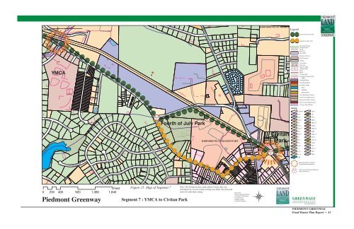
<strong>Piedmont</strong> <strong>Greenway</strong><br />
Figure 15. Map <strong>of</strong> Segment 7<br />
Segment 7 : YMCA to Civitan Park<br />
Note: The Zoning on these maps reflects County data, not<br />
individual city or town zoning. Zoning may differ. See cities and<br />
towns for individual zoning.<br />
Data From:<br />
Winston Salem GIS Dept.<br />
Greensboro GIS Depart.<br />
Forsyth County<br />
Guilford County<br />
NC DOT GIS Dept.<br />
PIEDMONT GREENWAY<br />
Final <strong>Master</strong> <strong>Plan</strong> Report • 41


