

Piedmont Greenway Master Plan - Town of Kernersville
Piedmont Greenway Master Plan - Town of Kernersville
Piedmont Greenway Master Plan - Town of Kernersville
- No tags were found...

You also want an ePaper? Increase the reach of your titles
YUMPU automatically turns print PDFs into web optimized ePapers that Google loves.
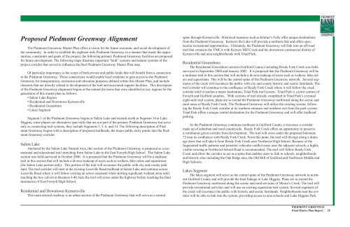
Proposed <strong>Piedmont</strong> <strong>Greenway</strong> Alignment<br />
The <strong>Piedmont</strong> <strong>Greenway</strong> <strong>Master</strong> <strong>Plan</strong> <strong>of</strong>fers a vision for the future economic and social development <strong>of</strong><br />
the community. In order to establish the eighteen mile <strong>Piedmont</strong> <strong>Greenway</strong> in a manner that meets the opportunities,<br />
constraints and goals <strong>of</strong> the project, the following primary <strong>Piedmont</strong> <strong>Greenway</strong> facilities are proposed<br />
for future development. The following maps illustrate important “built” systems and natural systems <strong>of</strong> the<br />
project corridor that served to influence the final <strong>Piedmont</strong> <strong>Greenway</strong> <strong>Master</strong> <strong>Plan</strong> map.<br />
Of particular importance is the scope <strong>of</strong> both private and public lands that will benefit from a connection<br />
to the <strong>Piedmont</strong> <strong>Greenway</strong>. These connections would enable local residents to gain access to the <strong>Piedmont</strong><br />
<strong>Greenway</strong> for transportation, recreation and education purposes defined within this <strong>Master</strong> <strong>Plan</strong>, and include<br />
elements that are directly related to development <strong>of</strong> the trail and associated support facilities. This description<br />
<strong>of</strong> the <strong>Piedmont</strong> <strong>Greenway</strong> alignment begins at the natural divisions that were identified as key regions for the<br />
generation <strong>of</strong> this master plan as follows:<br />
• Salem Lake Region<br />
• Residential and Downtown <strong>Kernersville</strong><br />
• Residential Greensboro<br />
• Lakes Segment<br />
Segment 1 <strong>of</strong> the <strong>Piedmont</strong> <strong>Greenway</strong> begins at Salem Lake and extends north to Segment 14 at Lake<br />
Higgins; some phases are alternative spur trails that are not part <strong>of</strong> the primary <strong>Piedmont</strong> <strong>Greenway</strong> but serve<br />
only as connecting trail systems, they include Segments 3, 5, 6, and 14. The following description <strong>of</strong> <strong>Piedmont</strong><br />
<strong>Greenway</strong> begins with a description <strong>of</strong> proposed trailheads, the major public entry points into the <strong>Piedmont</strong><br />
<strong>Greenway</strong> corridor.<br />
Salem Lake<br />
Anchored by the Salem Lake Natural Area, this section <strong>of</strong> the <strong>Piedmont</strong> <strong>Greenway</strong> is proposed as a recreational<br />
and educational trail stretching from Salem Lake to the East Forsyth High School. The Salem Lake<br />
section was field-surveyed in October 2000. It is proposed that the <strong>Piedmont</strong> <strong>Greenway</strong> will be a multiuse<br />
trail in this section that will include a diverse makeup <strong>of</strong> users such as walkers, bike riders and equestrians<br />
(for Salem Lake portion only). This portion <strong>of</strong> the trail will reconnect the public with city and county park<br />
land. The trail corridor will start at the existing Leesville Road trailhead at Salem Lake and continue across<br />
Leesville Road where it will follow existing an sewer easement while skirting significant wetland areas until<br />
reaching the box culvert at Business I-40, here the trail will cross under the highway before reaching the final<br />
destination <strong>of</strong> East Forsyth High School.<br />
Residential and Downtown <strong>Kernersville</strong><br />
This main arterial roadway is an urban section <strong>of</strong> the <strong>Piedmont</strong> <strong>Greenway</strong> that will serve as a central<br />
spine through <strong>Kernersville</strong>. Historical treasures such as Körner’s Folly <strong>of</strong>fer unique destinations<br />
from the <strong>Piedmont</strong> <strong>Greenway</strong>. <strong>Kernersville</strong> Lake will provide a northern link and <strong>of</strong>fers spectacular<br />
recreational opportunities. Ultimately, the <strong>Piedmont</strong> <strong>Greenway</strong> will link into an <strong>of</strong>f-road<br />
trail that connects the YMCA with Kerners Mill Creek and the downtown commercial district <strong>of</strong><br />
<strong>Kernersville</strong> and area neighborhoods with Triad Park.<br />
Residential Greensboro<br />
The Residential Greensboro section (Guilford County) including Reedy Fork Creek was fieldsurveyed<br />
in September 2000 and January 2001. It is proposed that the <strong>Piedmont</strong> <strong>Greenway</strong> will be<br />
a multiuse trail in this section that will include a diverse makeup <strong>of</strong> users such as walkers, bike riders<br />
and equestrians. This will be the central spine <strong>of</strong> the <strong>Piedmont</strong> <strong>Greenway</strong> network. Several segments<br />
<strong>of</strong> the creek will reconnect the public with city and county historic and scenic farmlands. The<br />
trail corridor will continue to the confluence <strong>of</strong> Reedy Fork Creek where it will follow the creek<br />
corridor until it reaches a major destination, Triad Park trail system. Triad Park is a joint venture <strong>of</strong><br />
Forsyth and Guilford counties. With sections <strong>of</strong> trail already completed in Triad Park’s eventual<br />
eight-mile trail system, plans are to extend the <strong>Piedmont</strong> <strong>Greenway</strong> northward along the scenic and<br />
rural areas <strong>of</strong> Reedy Fork Creek. The <strong>Piedmont</strong> <strong>Greenway</strong> will utilize the existing system, following<br />
the Reedy Fork Creek corridor at its southern entrance and northern exit from the park system.<br />
Triad Park <strong>of</strong>fers a unique central destination for the <strong>Piedmont</strong> <strong>Greenway</strong> and will <strong>of</strong>fer trailhead<br />
parking.<br />
As the <strong>Piedmont</strong> <strong>Greenway</strong> continues northeast in Guilford County, it traverses a corridor<br />
made up <strong>of</strong> suburban and rural countryside. Reedy Fork Creek <strong>of</strong>fers an opportunity to preserve<br />
a continuous green corridor from development. The trail will cross under the proposed Interstate<br />
73 near its confluence with Reedy Fork Creek. From this point, the trail will diverge along a drainage<br />
draw that will take it from Reedy Fork Creek near Northwest High School. Because <strong>of</strong> the<br />
fragmented traffic patterns and potential vehicular conflict areas near the adjacent schools, a highly<br />
visible crossing at Northwest School Road is recommended. The trail will follow Reedy Fork<br />
Creek and allow the corridor to act as a spine that enables users to link to schools, neighborhoods<br />
and historic sites including the Oak Ridge area, the Old Mill <strong>of</strong> Guilford and Northwest Middle and<br />
High Schools.<br />
Lakes Segment<br />
The lakes segment will serve as the central spine <strong>of</strong> the <strong>Piedmont</strong> <strong>Greenway</strong> network in northern<br />
Guilford County and will provide the final linkage to Lake Higgins. <strong>Plan</strong>s are to extend the<br />
<strong>Piedmont</strong> <strong>Greenway</strong> northward along the scenic and rural environs <strong>of</strong> Moore’s Creek. The trail will<br />
provide recreational activities and will use an existing equestrian trail system. Several segments <strong>of</strong><br />
the creek will reconnect the public with historic and scenic farmlands. Neighborhoods near the corridor<br />
will be able to link into the system, providing access to area schools and Lake Higgins Park.<br />
PIEDMONT GREENWAY<br />
Final <strong>Master</strong> <strong>Plan</strong> Report 25


