

Piedmont Greenway Master Plan - Town of Kernersville
Piedmont Greenway Master Plan - Town of Kernersville
Piedmont Greenway Master Plan - Town of Kernersville
- No tags were found...

You also want an ePaper? Increase the reach of your titles
YUMPU automatically turns print PDFs into web optimized ePapers that Google loves.
Estimate <strong>of</strong> Probable Land Acquisition Costs<br />
Land Ownership Inventory<br />
<strong>Greenway</strong>s, Inc. has completed a comprehensive land ownership inventory <strong>of</strong> the entire Forsyth<br />
County <strong>Piedmont</strong> <strong>Greenway</strong> corridor. The Guilford County parcel information is missing from this report<br />
because the County and the City <strong>of</strong> Greensboro will not release the information. Information that<br />
was obtained came from the Forsyth County Geo-Data web-site, and Winston-Salem/Forsyth County<br />
GIS and <strong>Plan</strong>ning Department data sets. The goal <strong>of</strong> identifying every parcel <strong>of</strong> land along both sides <strong>of</strong><br />
the greenway corridor and spur trails was not met due to the lack <strong>of</strong> information available from Guilford<br />
County. The research should be updated to reflect recent real estate transactions involving portions <strong>of</strong> the<br />
greenway corridor not yet included in tax records. It should be noted that city and county tax records are far<br />
from complete and, in some cases, may be out <strong>of</strong> date. In several instances, identification <strong>of</strong> owners <strong>of</strong> land<br />
in the greenway corridor was not possible.<br />
The ownership <strong>of</strong> the <strong>Piedmont</strong> <strong>Greenway</strong> corridor is highly fragmented. The corridor includes public,<br />
private and private nonpr<strong>of</strong>it landowners. Information about the public-private land ownership pattern was<br />
used in developing the proposed greenway trail alignment in order to maximize to the greatest extent possible<br />
utilization <strong>of</strong> publicly owned land for the greenway, thereby minimizing the cost <strong>of</strong> the public acquisition<br />
<strong>of</strong> land or easements for the greenway.<br />
A large portion <strong>of</strong> the land base required for the <strong>Piedmont</strong> <strong>Greenway</strong> is currently in public or private<br />
ownership. As discussed elsewhere in the <strong>Master</strong> <strong>Plan</strong> report, there are three large segments <strong>of</strong> the greenway<br />
owned by various city and county municipal governments. Public landowners in the corridor include<br />
the city <strong>of</strong> Winston Salem, city <strong>of</strong> Greensboro, the counties <strong>of</strong> Forsyth and Guilford and Duke Power Company.<br />
Public acquisition <strong>of</strong> land in public or private nonpr<strong>of</strong>it ownership is not included in the land acquisition<br />
cost estimate. However, although properties owned by these entities will not require public purchase<br />
for the greenway, land protection or management agreements must also be secured from public or private<br />
nonpr<strong>of</strong>it landowners.<br />
In all, there are 148 individual parcels <strong>of</strong> privately/publicly owned land in the greenway corridor (by<br />
an undetermined number <strong>of</strong> owners). A list <strong>of</strong> landowners is not included in the <strong>Master</strong> <strong>Plan</strong>, but can be<br />
obtained from the planning departments <strong>of</strong> Forsyth and Guilford Counties. Some information may also be<br />
available from Winston-Salem, Greensboro, and <strong>Kernersville</strong><br />
Land Acquisition Cost Estimate<br />
Based on the parcel depictions contained in tax maps, an approximate acreage for the greenway trail<br />
was calculated. As the entire parcel owned by each individual private landowner will not be required for the<br />
greenway, these acreage figures were reduced based on acquisition <strong>of</strong> a minimum 15-foot-wide easement<br />
(for an eight foot wide trail), in the urban Forsyth County section, and a 20-wide easement (for a ten foot<br />
wide trail) in the Guilford County section. Two alternatives trail segments were considered for the Forsyth<br />
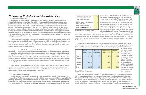
Forsyth County Primary Trail<br />
Alignment 8 foot-wide trail<br />
15 foot easement needed<br />
Guilford County Trail Alignment<br />
10 foot-wide trail<br />
20 foot easement needed<br />
Figure 45. Total Easement Acres<br />
County portion <strong>of</strong> the trail due to the pending high speed<br />
rail corridor that PART is studying. The first segment<br />
would follow the railway ROW, and an alternative trail<br />
would follow the southern side <strong>of</strong> West Mountain Street<br />
(see segments 1- 8, pages 29 - 43). Segment costs may<br />
be more or less depending on the final alignments and<br />
agreements with the landowners. Acreage for each<br />
parcel <strong>of</strong> private land over which the greenway will cross<br />
was then calculated using figures for linear front footage<br />
along the <strong>Piedmont</strong> <strong>Greenway</strong>. The total amount <strong>of</strong> land<br />
within the proposed primary greenway corridor is 3,423<br />
acres, <strong>of</strong> this approximately 1,268 acres are in the Forsyth County section and 2,155 acres are in the<br />
Guilford County section. As an alternative, the total amount <strong>of</strong> land within the alternative trail alignment<br />
is 3, 619 acres, <strong>of</strong> this approximately 1,464 acres are in Forsyth County and 2,155 acres are in<br />
Guilford County.<br />
Land acquisition costs are based on estimates only and are qualified by several factors. First,<br />
land acquisition costs are based on estimates from other recent sales <strong>of</strong> similar properties in the area.<br />
Until a qualified appraisal is performed by an NC State certified appraiser, the “fair market value”<br />
<strong>of</strong> these properties<br />
Forsyth<br />
County<br />
Guilford<br />
County<br />
Primary<br />
Parcel Acres<br />
Figure 46. Total Parcel Acres<br />
34<br />
58<br />
Total Easement Acres 92<br />
Number<br />
<strong>of</strong> Parcels<br />
Alternative<br />
Parcel Acres<br />
Number<br />
<strong>of</strong> Parcels<br />
1,268 74 1,464 250<br />
2,155 72 2,155 72<br />
Total 3,423 146 3,619 322<br />
will not be known.<br />
Secondly, these<br />
acquisition cost<br />
estimates are based<br />
on estimated acreage<br />
figures. Although<br />
general acreage can<br />
be obtained from<br />
public records, until<br />
an <strong>of</strong>ficial boundary<br />
survey <strong>of</strong> the corridor<br />
is made, exact acreage<br />
is unknown.<br />
These land acquisition cost estimates are also based on one further very important assumption:<br />
that the privately owned parcels to be acquired for the greenway are located within the 100-year<br />
floodplain <strong>of</strong> the creeks (where needed). Typically, property within the 100-year floodplain has a<br />
significantly reduced value due to the fact that the development potential <strong>of</strong> such property is highly<br />
limited. In many cases, properties within the 100-year floodplain <strong>of</strong> the various creeks may also<br />
contain jurisdictional wetlands, which greatly reduces the property’s development potential, and thus<br />
PIEDMONT GREENWAY<br />
Final <strong>Master</strong> <strong>Plan</strong> Report 69


