

Piedmont Greenway Master Plan - Town of Kernersville
Piedmont Greenway Master Plan - Town of Kernersville
Piedmont Greenway Master Plan - Town of Kernersville
- No tags were found...

Create successful ePaper yourself
Turn your PDF publications into a flip-book with our unique Google optimized e-Paper software.
Croyden<br />
Ches<br />
Legend<br />
Morris<br />
Primary <strong>Greenway</strong> Trail<br />
Conestoga<br />
Magnum<br />
Ches<br />
CASH ELEMENTARY<br />
<strong>Kernersville</strong> Lkae<br />
Spur Trail<br />
Walkertown Guthrie<br />
Martin Mill Creek<br />
Jones Brothers<br />
Road<br />
X<br />
Nandina<br />
McCracken<br />
Old Hollow<br />
Road<br />
X<br />
Kerwin<br />
Sutter<br />
Hopkins<br />
Mountain<br />
Existing Parkland<br />
& Open Space<br />
Roads<br />
Road UC<br />
Road EOP<br />
Streams & Rivers<br />
Road Unpaved<br />
Parking<br />
Power lines<br />
Railroads<br />
Railroad OBS<br />
Athletic Field<br />
Fence<br />
Ruins<br />
Exisitng Wall<br />
Existing Retaining Wall<br />
Utility<br />
Exisitng Bridge<br />
Exisitng Building<br />
Existing Canopy<br />
Pool<br />
Sidewalk<br />
Tennis Court<br />
Rubbins<br />
Pisgah Church<br />
Road<br />
X<br />
Clubb<br />
Cash Elementary School<br />
East Forsyth High School<br />
<strong>Kernersville</strong> Elem. School<br />
Wright<br />
<strong>Kernersville</strong> Middle School<br />
100 year Flood FEMA<br />
Elliott<br />
Zoning<br />
Road<br />
X<br />
Unknown<br />
NO S<br />
Weeping<br />
Chesham<br />
Road<br />
X<br />
Pisgah<br />
CB<br />
PB<br />
Peddycord Park<br />
GB<br />
GB S<br />
PB S<br />
RM12<br />
Walkertown Guthrie<br />
Road<br />
X<br />
Road<br />
X<br />
Road<br />
X<br />
Mountain<br />
Deer Crossing<br />
Hunters Path<br />
Doe Run<br />
Doe Run<br />
Willow Bend<br />
Raven Ridge<br />
Timber Forest<br />
Mill Brook<br />
Hunters<br />
Forrest Acres<br />
Timber Ridge<br />
Hunters<br />
Kerners Mill Creek<br />
Regents Park<br />
Windsor Park<br />
Regents Park<br />
Essen<br />
Reigate<br />
Regents Park<br />
Kelvdon<br />
Brightington<br />
Westbourne<br />
GI<br />
GI S<br />
GO S<br />
HB<br />
HB S<br />
IP<br />
IP S<br />
LB<br />
LB S<br />
LI<br />
LI S<br />
LO S<br />
MH<br />
RM12 S<br />
RM18<br />
RM18 S<br />
RM5<br />
RM8<br />
RM8 S<br />
RMU S<br />
RS12<br />
RS12 S<br />
RS20<br />
RS20 S<br />
RS7<br />
RS7 S<br />
State Road 2347<br />
Hastings Hill<br />
Mountain<br />
EAST FORSYTH HIGH<br />
Buck Run<br />
Raven Ridge<br />
Ashington<br />
Long Walk<br />
MH S<br />
NB<br />
NB S<br />
RS9<br />
RSQ<br />
Windsor Park<br />
Bluff School<br />
Road<br />
X<br />
Beginning and/or end points<br />
<strong>of</strong> measured trail segments.<br />
Trail crossing at Roads,<br />
Railroads, and/or Driveways.<br />
Feet<br />
0 425 850 1,700 2,550 3,400<br />
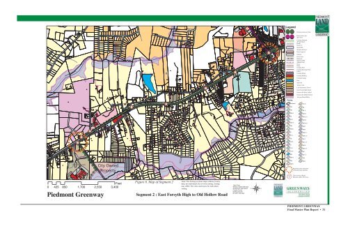
<strong>Piedmont</strong> <strong>Greenway</strong><br />
Figure 6. Map <strong>of</strong> Segment 2<br />
Note: The Zoning on these maps reflects County<br />
data, not individual city or town zoning. Zoning<br />
may differ. See cities and towns for individual<br />
zoning.<br />
Segment 2 : East Forsyth High to Old Hollow Road<br />
Data From:<br />
Winston Salem GIS Dept.<br />
Greensboro GIS Depart.<br />
Forsyth County<br />
Guilford County<br />
NC DOT GIS Dept.<br />
PIEDMONT GREENWAY<br />
Final <strong>Master</strong> <strong>Plan</strong> Report • 31


