

Piedmont Greenway Master Plan - Town of Kernersville
Piedmont Greenway Master Plan - Town of Kernersville
Piedmont Greenway Master Plan - Town of Kernersville
- No tags were found...

You also want an ePaper? Increase the reach of your titles
YUMPU automatically turns print PDFs into web optimized ePapers that Google loves.
Morganshire<br />
Parcel Data not Available<br />
Fogleman<br />
State Road 2299<br />
Beaver Creek<br />
Northwest School<br />
Macintosh<br />
Bunch<br />
Lomond<br />
Legend<br />
Primary <strong>Greenway</strong> Trail<br />
Existing Parkland<br />
& Open Space<br />
Roads<br />
Road UC<br />
Road EOP<br />
Streams & Rivers<br />
Road Unpaved<br />
Parking<br />
Power lines<br />
Railroads<br />
Railroad OBS<br />
Athletic Field<br />
Fence<br />
Ruins<br />
Exisitng Wall<br />
Existing Retaining Wall<br />
State Highway 68<br />
Hunting Cog<br />
Maloe<br />
Stafford Mill<br />
Beaver Creek<br />
Old Mill <strong>of</strong> Guilford<br />
Historic Site<br />
Reedy Fork Creek<br />
ROAD<br />
X<br />
PROPOSED I 73 CONNECTOR<br />
Parcel Data not Available<br />
Northwest Middle<br />
School<br />
Moore’s Creek<br />
Utility<br />
Exisitng Bridge<br />
Exisitng Building<br />
Wetlands<br />
100 year Flood FEMA<br />
Stream Crossing<br />
Data From:<br />
Winston Salem GIS Dept.<br />
Greensboro GIS Depart.<br />
Forsyth County<br />
Guilford County<br />
NC DOT GIS Dept.<br />
Guilford County Parcels<br />
ZONING information not availble<br />
Parcel color relates to property<br />
information found in GIS data table.<br />
Parcel data with<br />
property information<br />
Parcel data without<br />
property information<br />
Beginning and/or end points<br />
<strong>of</strong> measured trail segments.<br />
Grayleigh<br />
Brittains Field<br />
Gold Ridge<br />
Golden Acres<br />
Existing Powerlines<br />
Northwest High<br />
School<br />
Road<br />
X<br />
Trail crossing at Roads, Railroads,<br />
and/or Driveways.<br />
Note: The Zoning on these maps<br />
reflects County data, not individual city<br />
or town zoning. Zoning may differ. See<br />
cities and towns for individual zoning.<br />
Beckenham<br />
Millstaff<br />
Hwy 68<br />
Underpass<br />
Peeples<br />
Parcel Data not Available<br />
Knollcrest<br />
Alcorn<br />
Wallingford<br />
Wilder<br />
McAllen<br />
Feet<br />
0 462.5 925 1,850 2,775 3,700<br />
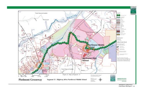
<strong>Piedmont</strong> <strong>Greenway</strong><br />
Figure 21. Map <strong>of</strong> Segment 11<br />
Segment 11 : Highway 68 to Northwest Middle School<br />
NOTE: Alignment <strong>of</strong> proposed I 73 Connector<br />
not yet determined, this map only should be<br />
used for general location <strong>of</strong> connector.<br />
Data From:<br />
Winston Salem GIS Dept.<br />
Greensboro GIS Depart.<br />
Forsyth County<br />
Guilford County<br />
NC DOT GIS Dept.<br />
PIEDMONT GREENWAY<br />
Final <strong>Master</strong> <strong>Plan</strong> Report • 49


