

Piedmont Greenway Master Plan - Town of Kernersville
Piedmont Greenway Master Plan - Town of Kernersville
Piedmont Greenway Master Plan - Town of Kernersville
- No tags were found...

You also want an ePaper? Increase the reach of your titles
YUMPU automatically turns print PDFs into web optimized ePapers that Google loves.
ADA Requirements<br />
The Americans with Disabilities Act requires that portions <strong>of</strong> the <strong>Piedmont</strong> <strong>Greenway</strong> System trail<br />
be accessible to persons with varying motor skills and abilities. Perhaps the best way to comprehend the<br />
importance <strong>of</strong> ADA is to understand that most <strong>of</strong> us, at some time in our life, will experience a temporary<br />
disability which will affect the way in which we make use <strong>of</strong> outdoor resources. The best examples include<br />
relying on crutches due to a broken leg; limited ambulatory movement due to a sprained muscle; or carrying<br />
two sacks <strong>of</strong> groceries from the car to the front door and not being able to see the ground or stairs below<br />
your feet. ADA benefits all Americans by making the outdoor environment more accessible.<br />
For the <strong>Piedmont</strong> <strong>Greenway</strong> Trail and spur trails, the consultant and client need to focus on several important<br />
issues related to ADA. One <strong>of</strong> these involves the "path <strong>of</strong> travel", which essentially means that from<br />
the point where an individual parks an automobile, the path <strong>of</strong> travel from the auto to the desired public resource<br />
and the length <strong>of</strong> trail throughout that resource all need to be clearly defined and free <strong>of</strong> barriers. For<br />
persons confined to a wheelchair, this means that parking spaces should be located in an area that provides<br />
optimal access to the greenway trail and complementary facilities. The consultant is proposing a 10-footwide<br />
asphalt or concrete paved primary trail which is wide enough to accommodate a variety <strong>of</strong> users,<br />
including persons who depend on wheelchairs for mobility. The consultant does not foresee circumstances<br />
at this time that would require special design solutions along the trail, or within designated trailheads, to accommodate<br />
users with special physical challenges.<br />
Trail Signage System<br />
A comprehensive system <strong>of</strong> signage is required throughout the project to ensure that information is<br />
provided to trail users regarding the safe and appropriate use <strong>of</strong> all facilities. Signage includes post- or polemounted<br />
signs and pavement striping. Signage is further divided into information signs, directional signs,<br />
regulatory signs and warning signs. Trail signage should be developed to conform to the (2001) Manual on<br />
Uniform Traffic Control Devices and the American Association <strong>of</strong> State Highway Transportation Official<br />
Guide for the Development <strong>of</strong> Bicycle Facilities . The needs <strong>of</strong> cyclists will require special attention, since<br />
this project is designed to accommodate bicycle traffic.<br />
The graphic below illustrates the type <strong>of</strong> signage system<br />
proposed for installation along the <strong>Piedmont</strong> <strong>Greenway</strong>.<br />
The consultant recommends the use <strong>of</strong> recycled waste<br />
materials and products in the construction <strong>of</strong> all signage<br />
for the project. <strong>Greenway</strong>s Incorporated has already constructed<br />
one greenway project using all recycled waste materials<br />
which <strong>of</strong>fer design versatility, <strong>of</strong>ten have a long life<br />
span, and require less long-term maintenance than similar<br />
products constructed from natural materials. Recycled<br />
3 feet<br />
(min.)<br />
10 feet (min.)<br />
10 to 12 ft. Trail<br />
3 feet<br />
(min.)<br />
plastic lumber and or concrete can be used for the construction <strong>of</strong> posts and poles, and recycled<br />
aluminum can be used for signs.<br />
Wayside Exhibits and <strong>Greenway</strong> Kiosk<br />
In addition to signage, the consultant also recommends educational and historical wayside<br />
exhibits throughout the project at selected sites. Wayside exhibits should be built adjacent to the<br />
main trail (or spur trails), or at the terminus <strong>of</strong> a connecting trail and should provide information<br />
on the environment or an important historic event that occurred in close proximity to the greenway.<br />
The trail user will become more aware <strong>of</strong> the landscapes they are traversing with exhibits relating<br />
to stream ecology, Native American history, flood control or water quality. These wayside exhibit<br />
areas can also provide rest areas where people can sit and relax.<br />
The history <strong>of</strong> the surrounding area is rich in both environmental and educational opportunities.<br />
The <strong>Kernersville</strong> portion will have exhibits on the history in the area as <strong>Kernersville</strong> is the<br />
site <strong>of</strong> important historic landmarks such as the one-room school house located in Fourth-<strong>of</strong>-July<br />
Park. The greenway will provide an excellent opportunity to tell the history <strong>of</strong> the town <strong>of</strong> <strong>Kernersville</strong><br />
and allow local citizens to become more familiar with important events in the area’s past.<br />
There are numerous opportunities to use small informational sites to tell the story <strong>of</strong> Forsyth and<br />
Guilford counties and the entire greenway system.<br />
The consultant notes that it is difficult in some areas to view the creeks and greenway from<br />
the higher elevations <strong>of</strong> adjacent roads, such as Highway 68 and the Pleasant Ridge Road Trail<br />
Head. Therefore, the consultant proposes placing greenway kiosks at the intersection <strong>of</strong> Highway<br />
68 and Alcorn Road and at the Pleasant Ridge Road Bridge to inform passing motorists <strong>of</strong><br />
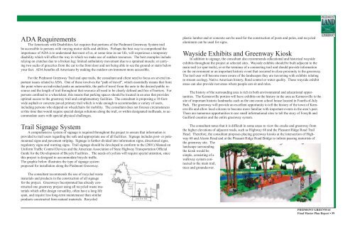
the greenway site. The<br />
landscape surrounding<br />
the kiosk would be<br />
simple, consisting <strong>of</strong> a<br />
walkway system connected<br />
to the main trail,<br />
trees and groundcover.<br />
PIEDMONT GREENWAY<br />
Final <strong>Master</strong> <strong>Plan</strong> Report • 59


