

Piedmont Greenway Master Plan - Town of Kernersville
Piedmont Greenway Master Plan - Town of Kernersville
Piedmont Greenway Master Plan - Town of Kernersville
- No tags were found...

Create successful ePaper yourself
Turn your PDF publications into a flip-book with our unique Google optimized e-Paper software.
Gaylord<br />
Morganshire<br />
Faye<br />
Legend<br />
Reedy Fork Creek<br />
Parcel Data not Available<br />
0<br />
Reedy Fork Creek<br />
Moore’s Creek<br />
Equestrian<br />
Trail Area<br />
Reedy Fork C<br />
Primary <strong>Greenway</strong> Trail<br />
Existing Parkland<br />
& Open Space<br />
Roads<br />
Road UC<br />
Road EOP<br />
Streams & Rivers<br />
Road Unpaved<br />
Parking<br />
Power lines<br />
Railroads<br />
Railroad OBS<br />
Athletic Field<br />
Fence<br />
Ruins<br />
Exisitng Wall<br />
Existing Retaining Wall<br />
Utility<br />
Bunch<br />
Exisitng Bridge<br />
Exisitng Building<br />
Westcott<br />
0<br />
Northwest School<br />
Macintosh<br />
Lomond<br />
Gwynedd<br />
Great Oaks<br />
Oak Glenn<br />
Timber Pegg<br />
Larue<br />
Windsor Farme<br />
Creed<br />
Trotter Ridge<br />
Dylan<br />
Existing Gas Pipeline<br />
Percheron<br />
Stanley Huff<br />
Horse Trail<br />
Deer Trail<br />
Ashbey<br />
Early<br />
Fitzhugh<br />
Ridge Trail<br />
Carlson Dairy<br />
Windcrest<br />
Hamburg Mill<br />
Data From:<br />
Winston Salem GIS Dept.<br />
Greensboro GIS Depart.<br />
Forsyth County<br />
Guilford County<br />
NC DOT GIS Dept.<br />
City Property<br />
Wetlands<br />
100 year Flood FEMA<br />
Stream Crossing<br />
Guilford County Parcels<br />
ZONING information not availble<br />
Parcel color relates to property<br />
information found in GIS data table.<br />
Parcel data with<br />
property information<br />
Parcel data without<br />
property information<br />
Beginning and/or end points<br />
<strong>of</strong> measured trail segments.<br />
Northwest Middle<br />
School<br />
0<br />
Moore’s Creek<br />
Pleasant Ridge<br />
Road<br />
X<br />
Trail crossing at Roads, Railroads,<br />
and/or Driveways.<br />
Note: The Zoning on these maps<br />
reflects County data, not individual<br />
city or town zoning. Zoning may<br />
differ. See cities and towns for<br />
individual zoning.<br />
Lewiston<br />
Northwest High<br />
School<br />
0<br />
Parcel Data not Available<br />
White Blossom<br />
Highland Grove<br />
Shoreline<br />
Long Valley<br />
Cedar Field<br />
0<br />
0<br />
0<br />
Feet<br />
0 600 1,200 2,400 3,600 4,800<br />
<strong>Piedmont</strong> <strong>Greenway</strong><br />
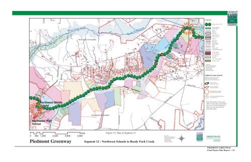
Figure 23. Map <strong>of</strong> Segment 12<br />
Segment 12 : Northwest Schools to Reedy Fork Creek<br />
Data From:<br />
Winston Salem GIS Dept.<br />
Greensboro GIS Depart.<br />
Forsyth County<br />
Guilford County<br />
NC DOT GIS Dept.<br />
PIEDMONT GREENWAY<br />
Final <strong>Master</strong> <strong>Plan</strong> Report • 51


