

Piedmont Greenway Master Plan - Town of Kernersville
Piedmont Greenway Master Plan - Town of Kernersville
Piedmont Greenway Master Plan - Town of Kernersville
- No tags were found...

You also want an ePaper? Increase the reach of your titles
YUMPU automatically turns print PDFs into web optimized ePapers that Google loves.
0<br />
Ira<br />
Main<br />
Chaucer Manor<br />
Clay Flynt<br />
Marylebone<br />
Thomas Drake<br />
Maple<br />
Kensal Green<br />
Hicks Edwards<br />
Smith Edwards<br />
Eastgrove<br />
Lear<br />
County Line<br />
Chelsea Place<br />
37<br />
0<br />
0<br />
0<br />
0<br />
0<br />
Willow Creek<br />
FORSYTH COUNTY<br />
GUILFORD COUNTY<br />
Willow Creek<br />
0<br />
0<br />
Eden Bridge<br />
TRIAD<br />
PARK<br />
Bay Brook<br />
0<br />
0<br />
Eden Terrace<br />
0<br />
0<br />
Crosscreek<br />
Existing Powerline<br />
0<br />
0<br />
0<br />
Parcel Data not Available<br />
0<br />
0<br />
0<br />
Morning Glory<br />
Road ROAD<br />
X<br />
Reedy Fork Creek<br />
0<br />
0<br />
County Line<br />
0<br />
Cherry Blossom<br />
Hollow Hill<br />
Existing Powerline<br />
0<br />
Reedy Fork Creek<br />
0<br />
0<br />
Beeson<br />
0<br />
ROAD<br />
X<br />
Road<br />
X<br />
0<br />
0<br />
Joywood<br />
Stafford Mill<br />
Bull<br />
0<br />
Existing Powerline<br />
00<br />
0<br />
0<br />
0<br />
Atkins Lake<br />
Marshall Smith<br />
0<br />
Legend<br />
Primary <strong>Greenway</strong> Trail<br />
Existing Parkland<br />
& Open Space<br />
Roads<br />
Road UC<br />
Road EOP<br />
Streams & Rivers<br />
Road Unpaved<br />
Parking<br />
Power lines<br />
Railroads<br />
Railroad OBS<br />
Athletic Field<br />
Fence<br />
Ruins<br />
Exisitng Wall<br />
Existing Retaining Wall<br />
Utility<br />
obscured area<br />
Exisitng Bridge<br />
Exisitng Building<br />
Existing Canopy<br />
Pool<br />
Sidewalk<br />
Tennis Court<br />
Cash Elementary School<br />
East Forsyth High School<br />
<strong>Kernersville</strong> Elem. School<br />
<strong>Kernersville</strong> Middle School<br />
100 year Flood FEMA<br />
Forsyth County Parcels<br />
ZONING<br />
Unknown<br />
CB<br />
GB<br />
GB S<br />
GI<br />
GI S<br />
GO S<br />
HB<br />
HB S<br />
NB S<br />
PB<br />
PB S<br />
RM12<br />
RM12 S<br />
RM18<br />
RM18 S<br />
RM8<br />
RMU S<br />
Berry Garden<br />
Pratt<br />
Crouse<br />
0<br />
Seacrest<br />
El Toro<br />
Sherbow<br />
Bunker Hill<br />
Parcel Data not Available<br />
IP<br />
IP S<br />
LB<br />
LB S<br />
LI<br />
LI S<br />
LO S<br />
MH<br />
RS12<br />
RS12 S<br />
RS20<br />
RS7<br />
RS7 S<br />
RS9<br />
RSQ<br />
Graves<br />
Lakeview<br />
El Matador<br />
Guilford County Parcels<br />
ZONING information not availble<br />
Parcel color relates to property<br />
information found in GIS data table.<br />
Spring<br />
Market<br />
Market<br />
Kidd<br />
Kidd<br />
Parcel data with<br />
property information<br />
Parcel data without<br />
property information<br />
Mountain<br />
81<br />
Pratt<br />
Sherfield<br />
Beginning and/or end points<br />
<strong>of</strong> measured trail segments.<br />
Road<br />
X<br />
Trail crossing at Roads, Railroads,<br />
and/or Driveways.<br />
Feet<br />
0 600 1,200 2,400 3,600 4,800<br />
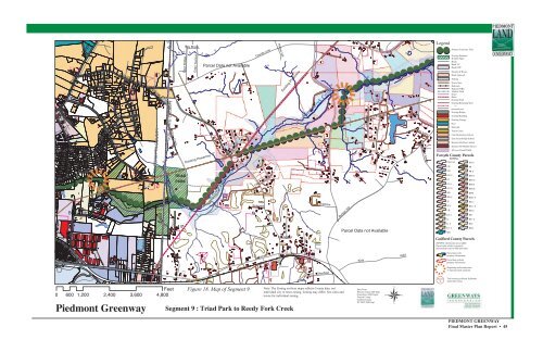
<strong>Piedmont</strong> <strong>Greenway</strong><br />
Figure 18. Map <strong>of</strong> Segment 9<br />
Segment 9 : Triad Park to Reedy Fork Creek<br />
Note: The Zoning on these maps reflects County data, not<br />
individual city or town zoning. Zoning may differ. See cities and<br />
towns for individual zoning.<br />
Data From:<br />
Winston Salem GIS Dept.<br />
Greensboro GIS Depart.<br />
Forsyth County<br />
Guilford County<br />
NC DOT GIS Dept.<br />
PIEDMONT GREENWAY<br />
Final <strong>Master</strong> <strong>Plan</strong> Report • 45


