

Piedmont Greenway Master Plan - Town of Kernersville
Piedmont Greenway Master Plan - Town of Kernersville
Piedmont Greenway Master Plan - Town of Kernersville
- No tags were found...

Create successful ePaper yourself
Turn your PDF publications into a flip-book with our unique Google optimized e-Paper software.
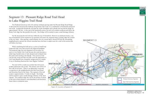
Segment 13: Pleasant Ridge Road Trail Head<br />
to Lake Higgins Trail Head<br />
The <strong>Piedmont</strong> <strong>Greenway</strong> trail will continue northeast passing under the Pleasant Ridge Road Bridge.<br />
At this point the trail proceeds northeast along Reedy Fork Creek via a combination <strong>of</strong> boardwalk and paved<br />
trail tread. A pedestrian boardwalk will span the creek's floodplain and wetlands just beyond the bridge for<br />
approximately 100 feet. At the end <strong>of</strong> the boardwalk section, the trail will continue northeast and follow the<br />
Reedy Fork ridge line that parallels the creek. One bridge will be needed to span a small drainage tributary.<br />
For the most part the trail will stay within the city <strong>of</strong> Greensboro. However as stated previously, a section<br />
<strong>of</strong> boardwalk will be required or an easement will need to be acquired along a sloping ridge line outside<br />
<strong>of</strong> the city limits. After passing a small tributary, the city-owned land is fenced <strong>of</strong>f from the surrounding<br />
neighborhoods to protect the critical watershed area, but there is ample room for a trail in this section that<br />
will follow the fence.<br />
SEGMENT 13<br />
While completing the field survey, a series <strong>of</strong> small loop<br />
(unpaved) trails were discovered in the adjacent floodplain.<br />
The proposed ridge line trail alignment will not allow for<br />
users to view Reedy Fork Creek because the creek becomes a<br />
rather large braided series <strong>of</strong> side channels and wetlands from<br />
this point until reaching Lake Brandt. This section <strong>of</strong> trail<br />
can provide a loop trail that will <strong>of</strong>fer users the opportunity to<br />
view Lake Brandt from a beautiful vantage point as it makes<br />
it way to Hamburg Road and the Lake Higgins Trailhead.<br />
The trail will be a multi-use corridor that will accommodate<br />
pedestrians and cyclists. The primary trail will be 10<br />
feet wide for all users. There is an opportunity to provide<br />
a connection to the neighborhoods near Oak Forest Road<br />
and Horseshoe Road in the future. This segment <strong>of</strong> the trail<br />
system is approximately 1.9 miles in length. One bridge<br />
will be needed to span a small drainage tributary <strong>of</strong> the main<br />
channel. The southern ridge line will be the primary location<br />
<strong>of</strong> the trail to help minimize creek disturbance and maximize<br />
future links to residential areas.<br />
Primary <strong>Greenway</strong> Segments<br />
Spur Trail <strong>Greenway</strong> Segments<br />
Figure 24. Location <strong>of</strong> Segment 13<br />
PIEDMONT GREENWAY<br />
Final <strong>Master</strong> <strong>Plan</strong> Report • 52


