

Piedmont Greenway Master Plan - Town of Kernersville
Piedmont Greenway Master Plan - Town of Kernersville
Piedmont Greenway Master Plan - Town of Kernersville
- No tags were found...

Create successful ePaper yourself
Turn your PDF publications into a flip-book with our unique Google optimized e-Paper software.
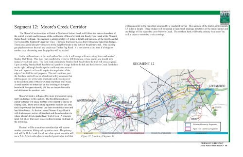
Segment 12: Moore's Creek Corridor<br />
The Moore's Creek corridor will start at Northwest School Road, will follow the eastern boundary <strong>of</strong><br />
the school property and terminate at the confluence <strong>of</strong> Moore's Creek and Reedy Fork Creek at the Pleasant<br />
Ridge Road Trailhead. This segment is approximately 3.5 miles in length and has some <strong>of</strong> the most beautiful<br />
views along the <strong>Piedmont</strong> <strong>Greenway</strong> Trail. There are four known areas that will require pedestrian bridges.<br />
These areas could also provide access to the neighborhoods to the north <strong>of</strong> the primary trail. One existing<br />
gas pipeline crosses the trail and creek near Timber Peg Road. It is not known at this time if a bridge or<br />
another type <strong>of</strong> crossing over the pipeline will be needed.<br />
As the trail continues on the north side <strong>of</strong> the creek, it will merge with an existing farm road west <strong>of</strong><br />
Stanley Huff Road. This farm road parallels the creek for 600 feet more or less, and its use should help<br />
reduce overall trail costs. The farm road continues to Stanley Huff Road where the trail will cross-at-grade.<br />
Upon crossing Stanley Huff Road the trail parallels a large field on the left and the Moore's Creek floodplain<br />
on the right. Although the floodplain could support a natural<br />
foot trail, a paved trail would require the acquisition <strong>of</strong> the<br />
edge <strong>of</strong> the field for trail purposes. The trail continues past<br />
the farmland and will use an abandoned utility easement that<br />
still has poles (no wires were observed) until crossing over<br />
to the southern side <strong>of</strong> Moore's Creek near Deer Trail Road.<br />
A small section on either side <strong>of</strong> this crossing will require<br />
boardwalk for approximately 150 feet on the northern side<br />
and 40 feet on the southern side.<br />
will run parallel to the main trail separated by a vegetated barrier. This segment <strong>of</strong> the trail is approximately<br />
3.5 miles in length. Three bridges will be needed to span small drainage tributaries <strong>of</strong> the main channel and<br />
one bridge will be needed to cross Moore's Creek. The northern bank will be the primary location <strong>of</strong> the<br />
trail in order to minimize creek crossings.<br />
SEGMENT 12<br />
Moore's Creek is influenced by more pronounced topography<br />
and ridges in this section. The floodplain and associated<br />
wetlands will cause the trail to be located at the toe <strong>of</strong><br />
sloping land. There are existing equestrian trails in this area<br />
and it is proposed that the trail use them to minimize cost and<br />
land disturbance. As the trail nears Pleasant Ridge Road it<br />
will skirt an open section <strong>of</strong> farmland and then drop down to<br />
where Moore's Creek meets Reedy Fork Creek. A concrete<br />
ramp will allow trail users to access the proposed trailhead on<br />
the north side.<br />
The trail will be a multi-use corridor that will accommodate<br />
pedestrian, biking and equestrian uses. The primary<br />
trail will be 10 feet wide for all users but equestrians who will<br />
use a 2- to 5-foot-wide adjacent crushed granite dust trail that<br />
Figure 22. Location <strong>of</strong> Segment 12<br />
Primary <strong>Greenway</strong> Segments<br />
Spur Trail <strong>Greenway</strong> Segments<br />
PIEDMONT GREENWAY<br />
Final <strong>Master</strong> <strong>Plan</strong> Report • 50


