

Piedmont Greenway Master Plan - Town of Kernersville
Piedmont Greenway Master Plan - Town of Kernersville
Piedmont Greenway Master Plan - Town of Kernersville
- No tags were found...

You also want an ePaper? Increase the reach of your titles
YUMPU automatically turns print PDFs into web optimized ePapers that Google loves.
Windcrest<br />
Bronco<br />
Wooden Rail<br />
Waterton<br />
Arabian<br />
Strawberry<br />
Legend<br />
Primary <strong>Greenway</strong> Trail<br />
Summerfield<br />
Trail crosses under<br />
existing bridge<br />
Annry<br />
Spur <strong>Greenway</strong> Trail<br />
Parcel Data not Available<br />
Existing Parkland<br />
& Open Space<br />
Roads<br />
Road UC<br />
Road EOP<br />
Horseshoe Bend<br />
Moore’s Creek<br />
Bunch<br />
Trail crosses under<br />
existing bridge<br />
Pleasant Ridge<br />
Reedy Fork Creek<br />
Summerfield Spur Trail<br />
Abandoned Rail Road Corridor<br />
Strawberry<br />
Strawberry<br />
Horseman<br />
Polo Farms<br />
Streams & Rivers<br />
Road Unpaved<br />
Parking<br />
Power lines<br />
Railroads<br />
Railroad OBS<br />
Athletic Field<br />
Fence<br />
Ruins<br />
Exisitng Wall<br />
Existing Retaining Wall<br />
Utility<br />
Hydro Buffers<br />
Wetlands<br />
100 year Flood FEMA<br />
City Property<br />
Stream Crossing<br />
Data From:<br />
Winston Salem GIS Dept.<br />
Greensboro GIS Depart.<br />
Forsyth County<br />
Guilford County<br />
NC DOT GIS Dept.<br />
Lake Brandt<br />
Guilford County Parcels<br />
ZONING information not availble<br />
Parcel color relates to property<br />
information found in GIS data table.<br />
Parcel data with<br />
property information<br />
Horseshoe<br />
Hamburg Mill<br />
Road<br />
ROAD<br />
X<br />
Parcel data without<br />
property information<br />
Beginning and/or end points<br />
<strong>of</strong> measured trail segments.<br />
Horse Trail<br />
Ashbey<br />
Early<br />
Deer Trail<br />
Fitzhugh<br />
Ridge Trail<br />
Parcel Data not Available<br />
Oak Forest<br />
Lake Higgins<br />
Trail Head<br />
Lake Higgins<br />
Battleground<br />
Bur Mill Club<br />
Road<br />
X<br />
Trail crossing at Roads, Railroads,<br />
and/or Driveways.<br />
Note: The Zoning on these maps reflects County<br />
data, not individual city or town zoning. Zoning<br />
may differ. See cities and towns for individual<br />
zoning.<br />
Data From:<br />
Winston Salem GIS Dept.<br />
Greensboro GIS Depart.<br />
Forsyth County<br />
Guilford County<br />
NC DOT GIS Dept.<br />
Feet<br />
0 445 890 1,780 2,670 3,560<br />
<strong>Piedmont</strong> <strong>Greenway</strong><br />
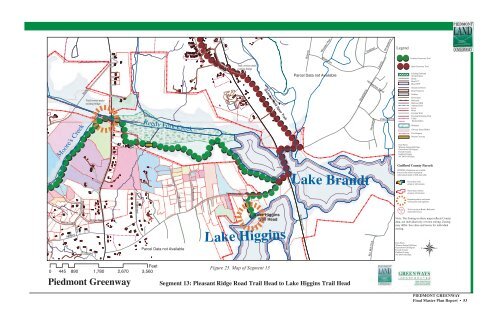
Figure 25. Map <strong>of</strong> Segment 13<br />
Segment 13: Pleasant Ridge Road Trail Head to Lake Higgins Trail Head<br />
PIEDMONT GREENWAY<br />
Final <strong>Master</strong> <strong>Plan</strong> Report • 53


