

Piedmont Greenway Master Plan - Town of Kernersville
Piedmont Greenway Master Plan - Town of Kernersville
Piedmont Greenway Master Plan - Town of Kernersville
- No tags were found...

Create successful ePaper yourself
Turn your PDF publications into a flip-book with our unique Google optimized e-Paper software.
Brittainywood<br />
Roberson Farm<br />
Valleydale<br />
Legend<br />
Primary <strong>Greenway</strong> Trail<br />
<strong>Kernersville</strong> Lake<br />
Spur Trail<br />
Creekridge<br />
Ches<br />
Ches<br />
Beulah<br />
Shaddowfax<br />
Old Hollow<br />
Roburton<br />
West<br />
Brittainywood<br />
Jones Brothers<br />
<strong>Piedmont</strong> <strong>Greenway</strong><br />
West<br />
Ches<br />
Ches<br />
Brittainywood<br />
CASH ELEMENTARY<br />
Barry Knoll<br />
Rivendell<br />
Weather Ridge<br />
Roxbury Forest<br />
Rivendell<br />
Feet<br />
0 362.5 725 1,450 2,175 2,900<br />
Roxbury<br />
Roxbury<br />
Old Hollow<br />
McCracken<br />
Wright<br />
Road<br />
X<br />
Kerwin<br />
Hopkins<br />
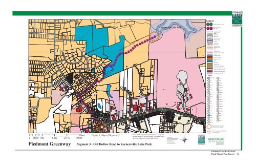
Figure 8. Map <strong>of</strong> Segment 3<br />
Segment 3 : Old Hollow Road to <strong>Kernersville</strong> Lake Park<br />
Fulp<br />
Road<br />
X<br />
Woodland<br />
Morris<br />
Road<br />
X<br />
Hoyd<br />
Kerners Mill Creek<br />
Note: The Zoning on these maps reflects County data,<br />
not individual city or town zoning. Zoning may differ.<br />
See cities and towns for individual zoning.<br />
Weslo<br />
Eastview<br />
Fennell<br />
Hoyd<br />
Data From:<br />
Winston Salem GIS Dept.<br />
Greensboro GIS Depart.<br />
Forsyth County<br />
Guilford County<br />
NC DOT GIS Dept.<br />
Mountain<br />
Zoning<br />
Road<br />
X<br />
Unknown<br />
CB<br />
GB<br />
GB S<br />
GI<br />
GI S<br />
GO S<br />
HB<br />
HB S<br />
IP<br />
IP S<br />
LB<br />
LB S<br />
LI<br />
LI S<br />
LO S<br />
MH<br />
MH S<br />
NB<br />
NB S<br />
Existing Parkland<br />
& Open Space<br />
Roads<br />
Road UC<br />
Road EOP<br />
Streams & Rivers<br />
Road Unpaved<br />
Parking<br />
Power lines<br />
Railroads<br />
Railroad OBS<br />
Athletic Field<br />
Fence<br />
Ruins<br />
Exisitng Wall<br />
Existing Retaining Wall<br />
Utility<br />
Exisitng Bridge<br />
Exisitng Building<br />
Existing Canopy<br />
Pool<br />
Sidewalk<br />
Tennis Court<br />
Cash Elementary School<br />
East Forsyth High School<br />
<strong>Kernersville</strong> Elem. School<br />
<strong>Kernersville</strong> Middle School<br />
100 year Flood FEMA<br />
NO S<br />
PB<br />
PB S<br />
RM12<br />
RM12 S<br />
RM18<br />
RM18 S<br />
RM5<br />
RM8<br />
RM8 S<br />
RMU S<br />
RS12<br />
RS12 S<br />
RS20<br />
RS20 S<br />
RS7<br />
RS7 S<br />
RS9<br />
RSQ<br />
Beginning and/or end points<br />
<strong>of</strong> measured trail segments.<br />
Trail crossing at Roads, Railroads,<br />
and/or Driveways.<br />
PIEDMONT GREENWAY<br />
Final <strong>Master</strong> <strong>Plan</strong> Report • 33


