

Piedmont Greenway Master Plan - Town of Kernersville
Piedmont Greenway Master Plan - Town of Kernersville
Piedmont Greenway Master Plan - Town of Kernersville
- No tags were found...

You also want an ePaper? Increase the reach of your titles
YUMPU automatically turns print PDFs into web optimized ePapers that Google loves.
Bunker Hill<br />
Saddle Brook<br />
Dapple Grey<br />
Beeson<br />
Parcel Data not Available<br />
Jerry<br />
Benbow Merrill<br />
Existing Powerlines<br />
Williard<br />
Beaver Creek<br />
Grayleigh<br />
Millstaff<br />
Stafford Mill<br />
Brittains Field<br />
Beckenham<br />
Hwy 68<br />
Underpass<br />
Peeples<br />
Legend<br />
Primary <strong>Greenway</strong> Trail<br />
Existing Parkland<br />
& Open Space<br />
Roads<br />
Road UC<br />
Road EOP<br />
Streams & Rivers<br />
Road Unpaved<br />
Parking<br />
Power lines<br />
Railroads<br />
Railroad OBS<br />
Athletic Field<br />
Fence<br />
Ruins<br />
Exisitng Wall<br />
Existing Retaining Wall<br />
Utility<br />
State Highway 68<br />
Exisitng Bridge<br />
Beaver Creek<br />
Baxter<br />
Stafford Mill<br />
Millstone<br />
Reedy Fork Creek<br />
Access<br />
Riding Trail<br />
Exisitng Building<br />
100 year Flood FEMA<br />
Stream Crossing<br />
Guilford County Parcels<br />
ZONING information not available<br />
Parcel color relates to property<br />
information found in GIS data table.<br />
Parcel data with<br />
property information<br />
Parcel data without<br />
property information<br />
County Line<br />
Beginning and/or end points<br />
<strong>of</strong> measured trail segments.<br />
Brynwood<br />
Road<br />
X<br />
Trail crossing at Roads, Railroads,<br />
and/or Driveways.<br />
Reedy Fork Creek<br />
ROAD<br />
X<br />
Ballard<br />
Castleford<br />
Lyon Creek<br />
Leabourne<br />
Barton<br />
Chrisfield<br />
Ballard<br />
Joywood<br />
Existing Powerlines<br />
Clairese<br />
Parcel Data not Available<br />
Cude<br />
Bull<br />
Atkins Lake<br />
<strong>Piedmont</strong> <strong>Greenway</strong><br />
Atkins Lake<br />
Feet<br />
0 550 1,100 2,200 3,300 4,400<br />
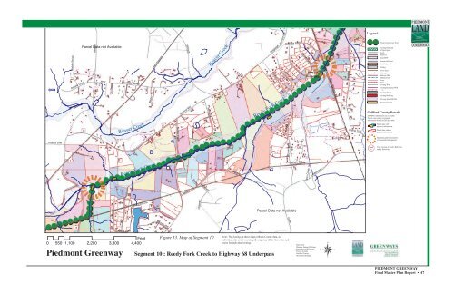
Figure 53. Map <strong>of</strong> Segment 10<br />
Note: The Zoning on these maps reflects County data, not<br />
individual city or town zoning. Zoning may differ. See cities and<br />
towns for individual zoning.<br />
Segment 10 : Reedy Fork Creek to Highway 68 Underpass<br />
Data From:<br />
Winston Salem GIS Dept.<br />
Greensboro GIS Depart.<br />
Forsyth County<br />
Guilford County<br />
NC DOT GIS Dept.<br />
PIEDMONT GREENWAY<br />
Final <strong>Master</strong> <strong>Plan</strong> Report • 47


