Space Grant Consortium - University of Wisconsin - Green Bay
Space Grant Consortium - University of Wisconsin - Green Bay
Space Grant Consortium - University of Wisconsin - Green Bay

Create successful ePaper yourself
Turn your PDF publications into a flip-book with our unique Google optimized e-Paper software.
From some <strong>of</strong> the information Kaymont had on their website regarding balloon performance we were<br />
able to get a better idea <strong>of</strong> how our balloons should be performing. The 1200 gram balloons we<br />
purchased had an average ascent rate <strong>of</strong> 1050 feet per minute with an average bursting altitude <strong>of</strong> a<br />
little over 30 kilometers. This now gave us some ground statistics which would allow us to better predict<br />
landing locations for future launches.<br />
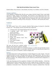
Command and Payload Pods<br />
The StratoSat system comes with one command pod and three payload pods. The command pod is<br />
responsible for flight data acquisition such as position, altitude, speed, and heading while the payload<br />
pods can be set up with other sensors to collect data such as temperature and pressure. The payload<br />
pods can communicate wirelessly with the command pod which sends all <strong>of</strong> the information gathered by<br />
both the command pod and the payload pod back to the tracking s<strong>of</strong>tware. Once tracking is complete<br />
the data can be simply exported into an excel file and analyzed even without the recovery <strong>of</strong> the system.<br />
Equipment Testing<br />
Since the tracking <strong>of</strong> our balloons was to be done with StartoStar Systems StratoSat setup, we began by<br />
installing Micros<strong>of</strong>t MapPoint and the StratoStar s<strong>of</strong>tware. The new StratoStar s<strong>of</strong>tware conveniently<br />
interfaced with Micros<strong>of</strong>t MapPoint which allowed for easy geographical location <strong>of</strong> the balloon. Before<br />
our first launch we took all <strong>of</strong> the StratoSat equipment outside to verify it was working properly. After<br />
overcoming a few obstacles with the USB to serial converters, we were able to locate the command pod<br />
on our computers. After tracking one <strong>of</strong> our team members driving around Milwaukee we concluded<br />
that the equipment was working properly.<br />
Our team quickly noticed that the command pods transmitter needed to be directionally positioned to<br />
the antenna receiver. For example, when the transmitter was pointed away from the antenna, the GPS<br />
transmitter on the command pod could not communicate with the receiver. While this remains an issue<br />
once the balloon is on the ground, this problem is diminished when the balloon is high above the GPS<br />
receiver.<br />
High Altitude Launch Opportunity (HALO) II<br />
The <strong>Wisconsin</strong> <strong>Space</strong> <strong>Grant</strong> Balloon Launch Team began its annual duties in the 2009-2010 season by<br />
participating in the High Altitude Launch Opportunity (HALO II) this spring. The HALO II project consisted<br />
<strong>of</strong> the simultaneous launching <strong>of</strong> 15 high altitude balloons from 15 universities in 9 different states. The<br />
purpose <strong>of</strong> the HALO II launch was to set up a high altitude communications network along with<br />
collecting temperature, humidity, pressure, altitude, CO2, rate, and radiation data. By having each<br />
payload transmit a radio frequency, the different balloons could link together through the radio<br />
transmissions and share data. Taylor <strong>University</strong> in Indiana served as the mission control for the project<br />
and through the communication network created, could receive data in real time. This eliminated the<br />
need for a sometimes unsuccessful recovery <strong>of</strong> the balloon.<br />
2