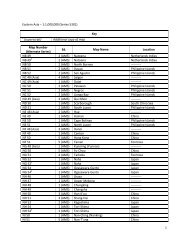
Space Grant Consortium - University of Wisconsin - Green Bay
Space Grant Consortium - University of Wisconsin - Green Bay
Space Grant Consortium - University of Wisconsin - Green Bay

You also want an ePaper? Increase the reach of your titles
YUMPU automatically turns print PDFs into web optimized ePapers that Google loves.
Providing High School Students with Earth Imaging Tools *<br />
Thomas C. Jeffery<br />
<strong>University</strong> <strong>of</strong> <strong>Wisconsin</strong> – Whitewater<br />
Abstract: Science education constitutes a significant segment <strong>of</strong> the core curriculum in primary<br />
and secondary schools. Traditionally, courses on Biology, Chemistry, and Physics constitute the<br />
majority <strong>of</strong> science education in most schools. Earth imaging, utilizing air photos or satellite<br />
images, can contribute to each <strong>of</strong> the disciplines above, however, without providing a foundation<br />
devoted to understanding earth imagery, the ability to extract meaning from the information<br />
provided is limited. This inability to incorporate earth imagery in primary and secondary schools<br />
had much less significance five years ago since the cost <strong>of</strong> the data made it prohibitive.<br />
However, the recent availability <strong>of</strong> Google Earth and the entire archive <strong>of</strong> Landsat imagery at no<br />
cost make earth imagery a frequently used tool in spatial problem solving in both the public and<br />
private sectors and also make it possible to <strong>of</strong>fer instruction on analyzing and interpreting earth<br />
imagery in primary and secondary education.<br />
Remote Sensing Value<br />
Earth imaging. Acquiring images o f t he earth’s s urface p redates t he i nvention <strong>of</strong> t he<br />
airplane, but it was the innovation <strong>of</strong> controlled flight and much later, unmanned satellites, that<br />
enabled a erial phot ography t o grow i nto t he va luable da ta s ource t hat i t h as b ecome (Jensen,<br />
2000). The ability to view large portions <strong>of</strong> the surface <strong>of</strong> the planet as it exists, and not as the<br />
result <strong>of</strong> i nterpretation or i nterpolation a llows t he vi ewer t o vi sually analyze f eatures a nd<br />
relationships. T he introduction in the mid and latter portions <strong>of</strong> the 20 th century <strong>of</strong> the satellite<br />
based i maging pl atform i ncreased t he t ype a nd vol ume <strong>of</strong> da ta t o i nclude m ultispectral<br />
information (Lillesand, et a l., 2004 ). T his h as led to e ven greater u tility o f th e ima gery for<br />
methods <strong>of</strong> compositional analysis.<br />
<strong>University</strong> level. Due to the value <strong>of</strong> aerial photography and satellite imagery as a means <strong>of</strong><br />
studying the form, structure, and composition <strong>of</strong> the earth’s surface, it was only natural that the<br />
study <strong>of</strong> e arth i magery be c ontained w ithin t he s cope <strong>of</strong> Geography and E arth S cience<br />
departments. Increasingly, ot her d epartments and di sciplines ha ve i ncorporated i magery a s a<br />
means <strong>of</strong> investigating and analyzing earth surface features and relationships. B iology, botany,<br />
environmental s tudies, chemistry, a nd ot hers are i ncreasingly r elying on i magery i n t heir<br />
investigations. Universities and research scientists were some <strong>of</strong> the initial users <strong>of</strong> this data, as<br />
they could afford the computing equipment and the cost <strong>of</strong> the data, however, very little <strong>of</strong> this<br />
technology has been adopted by primary and secondary schools.<br />
* This project was made possible by funding from the <strong>Wisconsin</strong> <strong>Space</strong> <strong>Grant</strong> <strong>Consortium</strong> and the <strong>University</strong> <strong>of</strong><br />
<strong>Wisconsin</strong>-Whitewater College <strong>of</strong> Letters and Sciences, along with the UW-W Geography & Geology department<br />
39