Nkomazi Local Municipality 20 - Co-operative Governance and ...
Nkomazi Local Municipality 20 - Co-operative Governance and ...
Nkomazi Local Municipality 20 - Co-operative Governance and ...
- No tags were found...

Create successful ePaper yourself
Turn your PDF publications into a flip-book with our unique Google optimized e-Paper software.
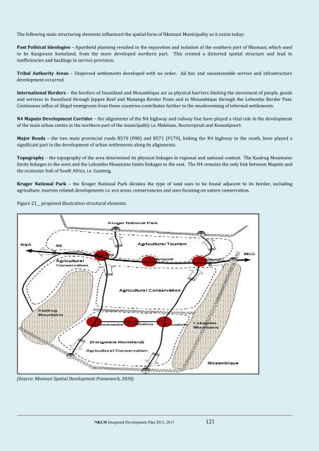
The following main structuring elements influenced the spatial form of <strong>Nkomazi</strong> <strong>Municipality</strong> as it exists today:Past Political Ideologies – Apartheid planning resulted in the separation <strong>and</strong> isolation of the southern part of <strong>Nkomazi</strong>, which usedto be Kangwane homel<strong>and</strong>, from the more developed northern part. This created a distorted spatial structure <strong>and</strong> lead toinefficiencies <strong>and</strong> backlogs in service provision.Tribal Authority Areas – Dispersed settlements developed with no order. Ad hoc <strong>and</strong> unsustainable service <strong>and</strong> infrastructuredevelopment occurred.International Borders – the borders of Swazil<strong>and</strong> <strong>and</strong> Mozambique act as physical barriers limiting the movement of people, goods<strong>and</strong> services to Swazil<strong>and</strong> through Jeppes Reef <strong>and</strong> Mananga Border Posts <strong>and</strong> to Mozambique through the Lebombo Border Post.<strong>Co</strong>ntinuous influx of illegal immigrants from these countries contributes further to the mushrooming of informal settlements.N4 Maputo Development <strong>Co</strong>rridor – the alignments of the N4 highway <strong>and</strong> railway line have played a vital role in the developmentof the main urban centes in the northern part of the municipality i.e. Malelane, Hectorspruit <strong>and</strong> Komatipoort.Major Roads – the two main provincial roads R570 (P80) <strong>and</strong> R571 (P179), linking the N4 highway to the south, have played asignificant part in the development of urban settlements along its alignments.Topography – the topography of the area determined its physical linkages in regional <strong>and</strong> national context. The Kaalrug Mountainslimits linkages to the west <strong>and</strong> the Lebombo Mountains limits linkages to the east. The N4 remains the only link between Maputo <strong>and</strong>the economic hub of South Africa, i.e. Gauteng.Kruger National Park – the Kruger National Park dictates the type of l<strong>and</strong> uses to be found adjacent to its border, includingagriculture, tourism related developments i.e. eco areas, conservancies <strong>and</strong> uses focusing on nature conservation.Figure 21__ proposed illustration structural elements(Source: <strong>Nkomazi</strong> Spatial Development Framework, <strong>20</strong>10)NKLM Integrated Development Plan <strong>20</strong>12_<strong>20</strong>13 121