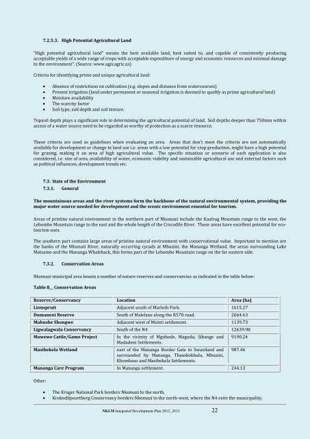
7.2.5.3. High Potential Agricultural L<strong>and</strong>“High potential agricultural l<strong>and</strong>” means the best available l<strong>and</strong>, best suited to, <strong>and</strong> capable of consistently producingacceptable yields of a wide range of crops with acceptable expenditure of energy <strong>and</strong> economic resources <strong>and</strong> minimal damageto the environment”. (Source: www.agis.agric.za)Criteria for identifying prime <strong>and</strong> unique agricultural l<strong>and</strong>:Absence of restrictions on cultivation (e.g. slopes <strong>and</strong> distance from watercourses)Present irrigation (l<strong>and</strong> under permanent or seasonal irrigation is deemed to qualify as prime agricultural l<strong>and</strong>)Moisture availabilityThe scarcity factorSoil type, soil depth <strong>and</strong> soil texture.Topsoil depth plays a significant role in determining the agricultural potential of l<strong>and</strong>. Soil depths deeper than 750mm withinaccess of a water source need to be regarded as worthy of protection as a scarce resource.These criteria are used as guidelines when evaluating an area. Areas that don’t meet the criteria are not automaticallyavailable for development or change in l<strong>and</strong> use i.e. areas with a low potential for crop production, might have a high potentialfor grazing, making it an area of high agricultural value. The specific situation or scenario of each application is alsoconsidered, i.e. size of area, availability of water, economic viability <strong>and</strong> sustainable agricultural use <strong>and</strong> external factors suchas political influences, development trends etc.7.3. State of the Environment7.3.1. GeneralThe mountainous areas <strong>and</strong> the river systems form the backbone of the natural environmental system, providing themajor water source needed for development <strong>and</strong> the scenic environment essential for tourism.Areas of pristine natural environment in the northern part of <strong>Nkomazi</strong> include the Kaalrug Mountain range to the west, theLebombo Mountain range to the east <strong>and</strong> the whole length of the Crocodile River. These areas have excellent potential for ecotourismuses.The southern part contains large areas of pristine natural environment with conservational value. Important to mention arethe banks of the Mlumati River, naturally occurring cycads at Mbuzini, the Mananga Wetl<strong>and</strong>, the areas surrounding LakeMatsamo <strong>and</strong> the Mananga Whaleback, this forms part of the Lebombo Mountain range on the far eastern side.7.3.2. <strong>Co</strong>nservation Areas<strong>Nkomazi</strong> municipal area boasts a number of nature reserves <strong>and</strong> conservancies as indicated in the table below:Table 8__ <strong>Co</strong>nservation AreasReserve/<strong>Co</strong>nservancy Location Area (ha)Lionspruit Adjacent south of Marloth Park. 1615.27Dumaneni Reserve South of Malelane along the R570 road. 2664.63Mahushe Shongwe Adjacent west of Mzinti settlement. 1139.73Ligwalagwala <strong>Co</strong>nservancy South of the N4 12639.98Mawewe Cattle/Game ProjectMasibekela Wetl<strong>and</strong>In the vicinity of Mgobode, Magudu, Sibange <strong>and</strong>Madadeni Settlements.east of the Mananga Border Gate to Swazil<strong>and</strong> <strong>and</strong>surrounded by Mananga, Thambokhulu, Mbuzini,Khombaso <strong>and</strong> Masibekela Settlements.9190.24987.46Mananga Care Program In Mananga settlement. 244.13Other:The Kruger National Park borders <strong>Nkomazi</strong> to the north,Krokodilpoortberg <strong>Co</strong>nservancy borders <strong>Nkomazi</strong> to the north-west, where the N4 exits the municipality,NKLM Integrated Development Plan <strong>20</strong>12_<strong>20</strong>13 22
Songimvelo Nature Reserve borders <strong>Nkomazi</strong> to the south-west, where the R38 exits the municipality.7.3.3. Biodiversity AssetsThe <strong>20</strong>07 Mpumalanga Biodiversity <strong>Co</strong>nservation Plan (MBCP) is a spatial plan that groups the province’s biodiversity assetsinto six conservation categories based on the measured distribution of hundreds of biodiversity <strong>and</strong> ecological featuresthroughout the province.The MBCP for Mpumalanga was superimposed on the municipal area. The categories <strong>and</strong> areas covered by each category areindicated in the table below. Refer to Chapter 7 for L<strong>and</strong> Use Guidelines for biodiversity conservation.Table 9__ Biodiversity assetsNr Category Area in NLM (ha)1 Protected areas – currently under formal biodiversity protection 140702 Irreplaceable areas – in urgent need of Protected Area status 171753 Highly Significant areas - requiring strict l<strong>and</strong> use controls 114584 Important <strong>and</strong> Necessary areas – requiring special care 106925 Areas of Least <strong>Co</strong>ncern – providing sites for development 1558456 Areas with No Natural Habitat remaining – providing preferred sites for allforms of developmentSource: Mpumalanga Biodiversity <strong>Co</strong>nservation Plan114369Furthermore, the Barberton Bio-Diversity <strong>Co</strong>rridor Initiative has identified <strong>Nkomazi</strong> to have good potential for consumptiveconservation, including game breeding <strong>and</strong> hunting.7.3.4. Natural EcologyThere are six Biomes in South Africa namely the Fynbos Biome, Ticket Biome, Forest Biome, Succulent Karoo Biome, GrassveldBiome <strong>and</strong> Savannah Biome. The municipality forms part of the Savannah Biome, which covers approximately 33% of the areaof South Africa. Generally, the Savannah Biome is characterised by a grassy ground layer <strong>and</strong> a distinct upper layer of woodyplants. Some sub-categories of the Savannah Biome form part of the municipality as follows (Source: DepartmentEnvironmental Affairs <strong>and</strong> Tourism <strong>20</strong>09).Sweet Lowveld Bushveld - located from the eastern parts of the Kruger National Park, southwards through Swazil<strong>and</strong> <strong>and</strong>into the northern parts of KwaZulu-Natal. In terms of climate, rainfall varies from 550 to 600 mm per year, falling insummer. Temperatures range between -2ºC <strong>and</strong> 43ºC, with an average of 22ºC.Mixed Lowveld Bushveld - located on flat to undulating l<strong>and</strong>scapes between 350 <strong>and</strong> 500m cutting across the municipalityfrom the north to the south. In terms of climate, the annual summer rainfall for the area varies from 450mm to 600mm.Temperatures vary between -4ºC <strong>and</strong> 45ºC, with an average of 22ºC.Lebombo Arid Mountain Bushveld – located on undulating rocky terrain on the eastern border of the Kruger NationalPark, extending through Swazil<strong>and</strong> into the northern part of KwaZulu-Natal. In terms of climate, the annual rainfallranges from 450mm to 700mm. Temperatures vary between -1ºC <strong>and</strong> 46ºC, with an average of 23ºC.Sour Lowveld Bushveld – located on the lower eastern slopes <strong>and</strong> foothills of the Drankensberg, from the Soutpansberg inLimpompo, through Mpumalanga <strong>and</strong> into Swazil<strong>and</strong> cutting across NLM. In terms of climate, the summer rainfall variesfrom 600mm to 1000mm per year. Temperatures range between 2ºC <strong>and</strong> 43ºC with an average of 22ºC.7.4. Demographic analysisThe demographic profile reflects the size, distribution, structure <strong>and</strong> socio-economic characteristics of the population of alocal municipality <strong>and</strong> how these population characteristics impact upon resources <strong>and</strong> sustainable community development.The population of any country or local municipality is changing, sometimes quite rapidly <strong>and</strong> recent data is required to plan<strong>and</strong> evaluate programmes. The dilemma is that accurate <strong>and</strong> reliable population data is not always readily available. Globallythe most complete <strong>and</strong> reliable source of information on the population of countries <strong>and</strong> their geographic subdivisions is thecensus based on a house-to-house enumeration. In South Africa the Statistics SA Census <strong>20</strong>01 <strong>and</strong> the Statistics SA <strong>Co</strong>mmunitySurvey <strong>20</strong>07 are currently the only two official population data source used mainly for planning purposes. It is in thisbackground that the compilation of the <strong>Nkomazi</strong> <strong>Local</strong> <strong>Municipality</strong>’s IDP is based on these two official population data source.NKLM Integrated Development Plan <strong>20</strong>12_<strong>20</strong>13 23