- Page 3 and 4: ACRONYMSABET : Adult Based Educatio
- Page 5 and 6: SECTION B 4910. STATUS QUO ANALYSIS
- Page 7 and 8: 19.22. Integrated Water Resources M
- Page 9 and 10: NKOMAZI EXCECUTIVE MAYOR’S FOREWO
- Page 12 and 13: DEFINITIONS AND KEY TERMSIntegrated
- Page 14 and 15: 4. MUNICIPALITY’S CORE VALUESThe
- Page 18 and 19: In addition, the Nkomazi Local Muni
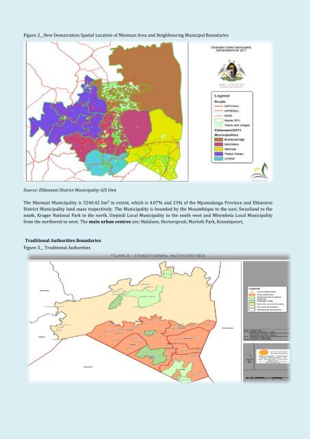
- Page 20 and 21: 7.2. Overview of nkomaziNkomazi is
- Page 22 and 23: 7.2.5.3. High Potential Agricultura
- Page 24 and 25: In ensuring that the Demographic in
- Page 30 and 31: 8. MUNICIPAL GOALS, OBJECTIVES AND
- Page 33: standardsandInfrastructuOperations
- Page 37 and 38: Ensure access toquality, sustainabl
- Page 39 and 40: DEPARTMENT: CORPORATE SERVICESYEAR:
- Page 41 and 42: Increasedappropriateutilizationofte
- Page 43 and 44: Strengthenintegratedplanningandacce
- Page 45 and 46: 9.2.2. Mpumalanga Provincial Growth
- Page 47 and 48: 9.4. Nkomazi role playersThe partic
- Page 49 and 50: SECTION B10. STATUS QUO ANALYSISThe
- Page 51 and 52: PercentageStrategic Objectives:Inte
- Page 53 and 54: In Place?Sufficient?In Place?Suffic
- Page 55 and 56: Public Works programmes 30%10.1.1.9
- Page 57 and 58: Free basic water policy (includinge
- Page 59 and 60: KPA 1 Table 17: Service delivery an
- Page 61 and 62: 10.1.2.2. Free basic sanitationThe
- Page 63 and 64: Axis Title10.1.3. Electrification o
- Page 65 and 66: 10.1.4. Roads and Storm WaterStrate
- Page 67 and 68:
KPA 1PriorityNotesTable 25: Service
- Page 69 and 70:
11. KPA 2: PUBLIC PARTICIPATION AND
- Page 71 and 72:
11.4. MANAGEMENT AND OPERATION SYST
- Page 73 and 74:
Nkomazi is one Municipality that is
- Page 75 and 76:
To provide family support services
- Page 77 and 78:
NKLM Integrated Development Plan 20
- Page 79 and 80:
13. KPA 4: FINANCIAL VIABILITYStrat
- Page 81 and 82:
Nkomazi. In 2007 the total unemploy
- Page 83 and 84:
Monitor the construction of housesE
- Page 85 and 86:
TABLE 30: SOCIAL SERVICES [HOUSING]
- Page 87 and 88:
15.3. EducationStrategic Objectives
- Page 89 and 90:
SECTION C17. DEVELOPMENT STRATEGIES
- Page 91 and 92:
Table 32__Service delivery and infr
- Page 93 and 94:
Table 33__Sanitation projectsDepart
- Page 95 and 96:
Table 36__Roads ProjectsDepartment
- Page 97 and 98:
Table 36__Roads ProjectsDepartment
- Page 99 and 100:
Table 36__Roads ProjectsDepartment
- Page 101 and 102:
Table 38__Waste Management Projects
- Page 103 and 104:
Table 39__Land Use Management Proje
- Page 105 and 106:
Table 40__Local Economic Developmen
- Page 107 and 108:
Table 41__Municipal Development and
- Page 109 and 110:
18.2. COMPREHENSIVE RURAL DEVELOPME
- Page 111 and 112:
Output 2 : Improved access to affor
- Page 113 and 114:
3.1.13.1.23.1.33.2.13.2.23.2.33.7.1
- Page 115 and 116:
3.5.13.5.23.5.3WaterTanksprovisionB
- Page 117 and 118:
4.1.2GardnersEmploymentProvide jobo
- Page 119 and 120:
SECTION E19. SECTOR PLANS19.1. Spat
- Page 121 and 122:
The following main structuring elem
- Page 123 and 124:
19.2. Disaster Management PlanThis
- Page 125 and 126:
19.8. Comprehensive Infrastructure
- Page 127 and 128:
19.13. Youth PolicyNkomazi Municipa
- Page 129 and 130:
19.21. Social Cohesion PlanThe Muni
- Page 131 and 132:
BUDGET SUMMARYTABLE 43_ ANNUAL OPER
- Page 133 and 134:
Cash backing/surplus reconciliation
- Page 135 and 136:
Audit Report22. Comments on the Aud
- Page 137 and 138:
Annual performance report notsubmit
- Page 139 and 140:
PAYE incorrectly calculatedPayment
- Page 141 and 142:
SECTION H24. ORGANISATIONAL PERFOMA
- Page 143 and 144:
1.3 Slow / lack ofimplementationof
- Page 145 and 146:
2 Operations and AdministrationOrga
- Page 147 and 148:
3.3. Sector Plans not in place: WSD
- Page 149 and 150:
4.2. Water infrastructure:BulkInade
- Page 151 and 152:
4.8 SanitationReticulationHigh sani
- Page 153 and 154:
5.1. Revenue Enhancement- Non-exist
- Page 155 and 156:
6.2 Maputo developmentCorridor Flag
- Page 157 and 158:
Sector Plan Status Approval Date Co
- Page 159 and 160:
27. ANNEXURES1. Financial Plan2. Sp
- Page 161 and 162:
Cllr. Hlahla BA•Ward - 11•Hhoyi
- Page 163 and 164:
Cllr. Sibiya SC•Ward - 31• Schu