Nkomazi Local Municipality 20 - Co-operative Governance and ...
Nkomazi Local Municipality 20 - Co-operative Governance and ...
Nkomazi Local Municipality 20 - Co-operative Governance and ...
- No tags were found...

You also want an ePaper? Increase the reach of your titles
YUMPU automatically turns print PDFs into web optimized ePapers that Google loves.
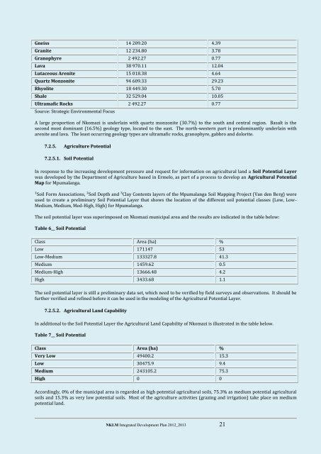
Gneiss 14 <strong>20</strong>9.<strong>20</strong> 4.39Granite 12 234.80 3.78Granophyre 2 492.27 0.77Lava 38 970.11 12.04Lutaceous Arenite 15 018.38 4.64Quartz Monzonite 94 609.33 29.23Rhyolite 18 449.30 5.70Shale 32 529.04 10.05Ultramafic Rocks 2 492.27 0.77Source: Strategic Environmental FocusA large proportion of <strong>Nkomazi</strong> is underlain with quartz monzonite (30.7%) to the south <strong>and</strong> central region. Basalt is thesecond most dominant (16.5%) geology type, located to the east. The north-western part is predominantly underlain witharenite <strong>and</strong> lava. The least occurring geology types are ultramafic rocks, granophyre, gabbro <strong>and</strong> dolorite.7.2.5. Agriculture Potential7.2.5.1. Soil PotentialIn response to the increasing development pressure <strong>and</strong> request for information on agricultural l<strong>and</strong> a Soil Potential Layerwas developed by the Department of Agriculture based in Ermelo, as part of a process to develop an Agricultural PotentialMap for Mpumalanga.¹Soil Form Associations, ²Soil Depth <strong>and</strong> ³Clay <strong>Co</strong>ntents layers of the Mpumalanga Soil Mapping Project (Van den Berg) wereused to create a preliminary Soil Potential Layer that shows the location of the different soil potential classes (Low, Low-Medium, Medium, Med-High, High) for Mpumalanga.The soil potential layer was superimposed on <strong>Nkomazi</strong> municipal area <strong>and</strong> the results are indicated in the table below:Table 6__ Soil PotentialClass Area (ha) %Low 171147 53Low-Medium 133327.8 41.3Medium 1459.62 0.5Medium-High 13666.48 4.2High 3433.68 1.1The soil potential layer is still a preliminary data set, which need to be verified by field surveys <strong>and</strong> observations. It should befurther verified <strong>and</strong> refined before it can be used in the modeling of the Agricultural Potential Layer.7.2.5.2. Agricultural L<strong>and</strong> CapabilityIn additional to the Soil Potential Layer the Agricultural L<strong>and</strong> Capability of <strong>Nkomazi</strong> is illustrated in the table below.Table 7__ Soil PotentialClass Area (ha) %Very Low 49400.2 15.3Low 30475.9 9.4Medium 243105.2 75.3High 0 0Accordingly, 0% of the municipal area is regarded as high potential agricultural soils, 75.3% as medium potential agriculturalsoils <strong>and</strong> 15.3% as very low potential soils. Most of the agriculture activities (grazing <strong>and</strong> irrigation) take place on mediumpotential l<strong>and</strong>.NKLM Integrated Development Plan <strong>20</strong>12_<strong>20</strong>13 21