- Page 1 and 2:
Version 7.0EnglishLeica GPS1200+Sys
- Page 3 and 4:
Name Description FormatSystem Field
- Page 5 and 6:
10 Linework 6910.1 Performing Linew
- Page 7 and 8:
26 Menu Tree 213Index 215Table of C
- Page 9 and 10:
1 User Interface1.1 KeyboardKeyboar
- Page 11 and 12:
1.2 ScreenScreenabcdeGPS12 129kfghi
- Page 13 and 14:
AppearanceDescriptionORTap on the i
- Page 15 and 16:
1.4 IconsDescriptionIcons show the
- Page 17 and 18:
Real-time mode: RoverAn arrow point
- Page 19 and 20:
IconDescriptionThe internal memory
- Page 21 and 22:
1.5 SymbolsDescriptionFilterThe sym
- Page 23 and 24:
2 Equipment Setup2.1 Receiver Ports
- Page 25 and 26:
2.3 Real-Time Reference, Single Tri
- Page 27 and 28:
2.5 SmartRover - External RadioUseE
- Page 29 and 30:
Position of cablesin the minipackca
- Page 31 and 32:
9.3 mm3 Determining Antenna Heights
- Page 33 and 34:
4 Using RX12504.1 Switching between
- Page 35 and 36:
4.3 Interface Configuration4.3.1 Ov
- Page 37 and 38:
4.3.3 Configuring Clip-On Interface
- Page 39 and 40:
5 Receiver Protection with PINDescr
- Page 41 and 42:
6 Manage... - Getting StartedAccess
- Page 43 and 44:
SHIFT DEFLT (F5)Available for MANAG
- Page 45 and 46:
7 Manage...\Jobs7.1 OverviewDescrip
- Page 47 and 48:
Next stepPAGE (F6) changes to the C
- Page 49 and 50:
8 Manage...\Data8.1 OverviewDescrip
- Page 51 and 52:
SHIFT INDIV (F5) or SHIFT RUN (F5)T
- Page 53 and 54:
Next stepIFcreating a pointTHENSTOR
- Page 55 and 56:
EDIT (F3)To view and edit the highl
- Page 57 and 58:
8.3 Line/Area Management8.3.1 Overv
- Page 59 and 60:
Field Option Description Choicelist
- Page 61 and 62:
8.4 Point Sorting and Filters8.4.1
- Page 63 and 64:
8.4.2 Point, Line and Area Code Fil
- Page 65 and 66:
9 Manage...\Codelists9.1 Creating a
- Page 67 and 68:
NEW-A (F2)To add a new input field
- Page 69 and 70:
10 Linework10.1 Performing Linework
- Page 71 and 72:
Field Option DescriptionReOpen AnyA
- Page 73 and 74:
SURVEYSurvey: Job Name,Survey pageT
- Page 75 and 76:
11 Manage...\Coordinate Systems11.1
- Page 77 and 78:
Field Option Description Choicelist
- Page 79 and 80:
11.3.2 Creating/Editing a Transform
- Page 81 and 82:
11.4 Geoid/CSCS ModelsThe creation
- Page 83 and 84:
12 Manage...\Configuration Sets12.1
- Page 85 and 86:
12.3 Editing a Configuration SetAcc
- Page 87 and 88:
13 Manage...\Antennas13.1 OverviewD
- Page 89 and 90:
MANAGENew Antenna,IGS pageThe combi
- Page 91 and 92:
14 Convert...\Export Data from Job1
- Page 93 and 94:
Field Option DescriptionData, GSI o
- Page 95 and 96:
14.4 Exporting LandXML DataGeneralA
- Page 97 and 98:
15 Convert...\Import Data to Job15.
- Page 99 and 100:
Field Option Description Choicelist
- Page 101 and 102:
16 Convert...\Copy Points Between J
- Page 103 and 104:
17 Config...\Survey Settings...17.1
- Page 105 and 106:
17.2 Display SettingsDescriptionDis
- Page 107 and 108:
17.3 Coding & LineworkDescriptionAc
- Page 109 and 110:
17.4 Quality Control SettingsDescri
- Page 111 and 112:
Field Option DescriptionFrom 0.05s
- Page 113 and 114:
Field Option DescriptionChoicelistC
- Page 115 and 116:
CONFIGUREReal-Time StopCriteriaDesc
- Page 117 and 118:
18 Config...\Instrument Settings...
- Page 119 and 120:
Field Option Description Automatic
- Page 121 and 122:
18.4 Instrument IDDescriptionAccess
- Page 123 and 124:
19 Config...\General Settings...19.
- Page 125 and 126:
19.3 Units & FormatsDescriptionAcce
- Page 127 and 128:
Field Option DescriptionLat,Long or
- Page 129 and 130:
19.5 Display, Beeps, TextDescriptio
- Page 131 and 132:
19.6 Start Up & Power DownDescripti
- Page 133 and 134:
20 Config...\Interfaces... - Genera
- Page 135 and 136:
20.2 Real-Time20.2.1 OverviewDescri
- Page 137 and 138:
20.2.3 Configuration of a Reference
- Page 139 and 140:
Field Option Description Bluetooth
- Page 141 and 142:
Field Option Description Choicelist
- Page 143 and 144: Description of fieldsField Option D
- Page 145 and 146: Description of fieldsField Option D
- Page 147 and 148: Field Option DescriptionLogShow and
- Page 149 and 150: 20.2.6 Configuration of GGA Message
- Page 151 and 152: 20.3 Hidden PointDescriptionAccessC
- Page 153 and 154: Next stepStep Description1. CONT (F
- Page 155 and 156: Field Option DescriptionBluetooth x
- Page 157 and 158: Field Option Description User input
- Page 159 and 160: 21 Configuration of Devices21.1 Ove
- Page 161 and 162: Next stepCONT (F1) closes the scree
- Page 163 and 164: Field Option DescriptionCRNot avail
- Page 165 and 166: 22 Config...\Interfaces... - Contro
- Page 167 and 168: Description of fieldsField Option D
- Page 169 and 170: 22.3 RadiosDescriptionAccessCONFIGU
- Page 171 and 172: 22.5 GPRS / Internet DevicesDescrip
- Page 173 and 174: Field Option Description User input
- Page 175 and 176: Next stepStep Description1. STORE (
- Page 177 and 178: 23 Tools...23.1 Format Memory Devic
- Page 179 and 180: 23.3 Upload System Files...Descript
- Page 181 and 182: 23.5 Licence KeysDescriptionAccessW
- Page 183 and 184: Way of workingstep-by-stepStep Desc
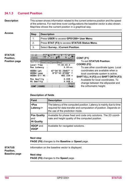
- Page 185 and 186: 24 STATUS24.1 STATUS: Survey...24.1
- Page 187 and 188: Description of symbolsSymbolDescrip
- Page 189 and 190: FieldDescriptionAvailable for Galil
- Page 191 and 192: Name of pageRef (Nearest)pageRef (i
- Page 193: Field,,,,,DescriptionThe pseudorang
- Page 197 and 198: STATUSLogging,Ring Buffer pageDescr
- Page 199 and 200: 24.1.5 Occupation Information Statu
- Page 201 and 202: 24.2 STATUS: Battery & MemoryAccess
- Page 203 and 204: 24.3 STATUS: System InformationAcce
- Page 205 and 206: 25 NTRIP via Internet25.1 OverviewD
- Page 207 and 208: StepTheDescriptionreceiver is now o
- Page 209 and 210: Step DescriptionHighlight Real-Time
- Page 211 and 212: StepDescription Indicates if charge
- Page 213 and 214: 26 Menu TreeMenu treeMAIN MENU||—
- Page 215 and 216: IndexAAbsolute coordinate differenc
- Page 217 and 218: Ellipsoid .........................
- Page 219 and 220: Mechanical reference plane ........
- Page 221 and 222: On, off ...........................