V A L DE RES E A RC H G ROD P, L LCREA L EST ATE AN A LV S T SAN D C O.N S U L TAN T SDecember 12,.2008Wiliam Matsikoudis, Corporation Counsel<strong>City</strong> of <strong>Jersey</strong> <strong>City</strong>Law Department280 Grove Street<strong>Jersey</strong> <strong>City</strong>, NJ 07302Re: Siegel PropertySip Avenue & Routes 1 & 9<strong>Jersey</strong> <strong>City</strong>, New <strong>Jersey</strong>,. ,", Dear Mr. Matsikoudis:The <strong>City</strong> of Jerseý <strong>City</strong> has authorized Value Research Group, LLC to appraise a 32.52-acre tract of land owned by,Edwin L. Siegel and a related entity, Edlin, Ltd, The <strong>City</strong>intends to use the appràisal in connection with a proposedprope~ty acquisition." The subject property is a' 32.52-acre tract of land located at the intersection of Sip Avenueand Tnick Route 1'& 9. Existing operations on the site include a truck stop and'fúelingfacility and a'commercial building. Theseimprovements occupy approximately two acresof land located along the site's Truck Route 1 & 9 frontage. The Sip Averiue ditch, aman-made drainage ditch' that forms the subject property's southern boundary, runs westto the BackensackRiver from a city storm sewer outlet atTruck Route 1 & 9. The'Pulaski Skyway, an elevattid highway, runs through the'subject property from thenortheast to southwest. The Skywàyeffeetively divides the, property into two discretesections; 17.4.3 :-acres west of theSkyway'Skyway and 15. 09~acres of Vacant land east of the, The site is part of a Superfund site known as the PJP LandfiL. As such, the site was placedon the EPA's National Priority Listin December J982~ The site is contaminated by avariety of toxic substances and much of the site is covered with landfil material: To gaina: better understanding of the Site's environmental and geoteèhnical conditions, I havereviewed an engineering study prepared by Golder Associates entitle'd' Pre-Final (90Percent) Remedial Design Report - PIP Landfill Site, lerser <strong>City</strong>, New lerser. The report,dated June 2004, was prepared for Waste Management of New <strong>Jersey</strong>. References to thisstudy appear throughout the appraisal and the complete report is available for reviewupon request. Despite the presence of on-site contamination, the subjectbeen valued as ¡ffully remediated in accordance with currerit law,property has~.""Clluere-.Oten.co,n30' :sqUTH UVINc;STON AvENUE. SUITE 104 . UVINGSTON . New.JE'r;e.. . 0"1039 . o;73.422~9.600 . FAX 973..22-'9797
Wiliam MatsikoudisDecember 12,2007Page 2", ,; The subjeçt property is located in the Hackensack River Edge RedevelopmeritAi:ea. OnSeptember 27,2006, the <strong>City</strong> of <strong>Jersey</strong> <strong>City</strong> adopted a redevelopment plan for thedesignated area. Prior to its inc1usionin a Redevelopment Area, most of the subjectproperty was located in the I-Industrial, a distriCt that permitted a broad range ofindustrial uses including manufacturing, assembly, waIehousing, distribution, truckterminal, office and, research uses. A smaller portion of the property was situated in theWPD Waterfront Planned Development District,where a variety of recreational,commercial and residential uses were permitted,The requirements ofthe Redevelopment Plan are not applicable to this a~signment, whichrequires the appraiser to factor out all appreciating and depreciatinginfluences of the<strong>City</strong>'s redevelopment project. Therefore, the subject property Ís appraised in accordancewith the requirements of the I-Industrial and WPD districts. Given the existing siteconditions, its location, physiCàl characteristics and surrounding land uses, the highestand best uSe of the subject property is for industrial development consistent with therequirements of the I-Industrial District.I have researched, identified and gathered, verified, and analyzed all of the data appearingwithin .the àttached appraisal report. Based on myfindingsand analysis, I have formedthe opinion that the market value of the subject property's fee simple estate as öfNovember 1, 2008 was: '2.00 acres of land along Route 1 & 9and Existing Improvements:13.09":acres oflandeast of the Skyway:17.43-acres of land west of the Skyway:$ 2,915,000$ 4,189,000$ 5,578,000Total MarketValue of the Subject Property$12,682,000Very truly yours;VALUE RESEARCH GROUP, LLC.lJlAR;ßPaùl T. Beisser,CRE, MAlState Cettified General RealEstate Appraiser (RG 00181)File #446930t SOUTH UVINGSTON ..VENUE ..SUITE .1"04" ~ =;~~~;"~~~~'~::;e.. .. 0'103Q .. Çt73-42~9S00 .. ':AX 973..2'-o79'1
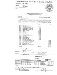
- Page 1 and 2:
Cit Clerk File No.Ordi 11-001Agenda
- Page 3 and 4:
City Clerk File No.. Agenda No.Agen
- Page 5 and 6:
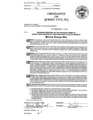
. .Continuation of City Ordinance11
- Page 7 and 8:
COntinuatlònof City Ordinance 11-0
- Page 9 and 10:
Continuation of City Ordinance ll-U
- Page 11 and 12:
Continuation of City Ordinance11-.0
- Page 13 and 14:
LIBERTY HARBOR REDEVELOPMENT PLANMA
- Page 15 and 16:
. VIII. MAS .................;.....
- Page 17 and 18:
I. ,BOUNDARY DESCRIPTION, BEGINING
- Page 19 and 20:
C. ' Duration and Effective Date of
- Page 21 and 22:
This redevelopment plan authorizes
- Page 23 and 24:
y providing the pedestran environme
- Page 25 and 26:
or mechanical floor area adjacent t
- Page 27 and 28:
project sne. -V. ,Parking and servi
- Page 29 and 30:
, 'The Planing Board may grant devi
- Page 31 and 32:
C. Restriction of Occupancy or UseT
- Page 33 and 34:
1. Maximum height: heightshall be r
- Page 35 and 36:
. Buildings shall be constrcted on
- Page 37 and 38:
porton of the façade of the parkin
- Page 39 and 40:
econstrcted, non-conforrity with th
- Page 41 and 42:
MAPSc,, , ,, 25
- Page 44 and 45:
"CIRCULATION MAP.b~BiJt BO.UNOARY -
- Page 46 and 47:
-Residential, Mixed-UseDistrict Bou
- Page 48 and 49:
o~~. r--------------------'~ I r r
- Page 50 and 51:
~ __Ø)'June 2010MAP NO.9/ '
- Page 52 and 53:
o~"~zu~-LEGENDi- ~'.--------,.....,
- Page 54 and 55:
1-- -_~- -- ~- ~- --- ~~- ---'\LEGE
- Page 56 and 57:
Cit Clerk File No.Agenda No.Agenda
- Page 58 and 59:
ORDINANCE FACT SHEETDate Submitted
- Page 60 and 61:
TABLE OF CONTENTSAmendments to the
- Page 62 and 63:
The following Map Footnotes shall b
- Page 64 and 65:
11.-- DESCRIPTION OF PROJECTA. Rede
- Page 66 and 67:
golf courses, driving ranges, water
- Page 68 and 69: · In no instance, no matter what t
- Page 70 and 71: d. Modem, decorative, pedestrian fr
- Page 72 and 73: StudioI Bedroom2 Bedroom & above0.5
- Page 74 and 75: various plant species to be usedber
- Page 76 and 77: d. Entrances and exits to parking a
- Page 78 and 79: Additionally, the logo and/or hotel
- Page 80 and 81: c. Golf Clubhoused. Professional an
- Page 82 and 83: In addition, all areas of the roof
- Page 84 and 85: 11. Additional Step-back Requiremen
- Page 86 and 87: , structures in poor condition and
- Page 88 and 89: ./,LIBERTY HARBOR REDEVELOPMENT ARE
- Page 90 and 91: CIRCULATION MAPLEGEND'---- BO.UNOAR
- Page 92 and 93: LEGEND_...-Libert HarborRedevelopme
- Page 94 and 95: lIBERTV DRIVEIIIIIIII,-- - - - - -
- Page 96 and 97: og0-"~~mnmmTDmnrnmn- L ' ,"ORRiS '
- Page 98 and 99: ,--------; r,,IIIII,II , ------- --
- Page 100 and 101: o~0-Z~g. I---~--._---------------II
- Page 102 and 103: Cit Clerk File No.Agenda No.Agenda
- Page 104 and 105: Continuation at ~ity urqinance ,'pa
- Page 106 and 107: ~ f j!~1ê5 h_~-,~fi,' u-~Jl 'e, ,
- Page 108 and 109: Area") and to utilize such Access A
- Page 110 and 111: . '..such, it is mandatory that the
- Page 112 and 113: . .' ~IN WITNESS WHEREOF, Grantor s
- Page 114 and 115: ..E-H p:ã~ltJfNO~ ~..I\Il~I;CI""..
- Page 116 and 117: EXHIBIT BMETES AND BOUNDS(TO,BE PRO
- Page 120 and 121: , ~ ,SUMMARY APPRAISAL REPORTi PORT
- Page 122 and 123: , ,Portion of PJP Landfill Site, Je
- Page 124 and 125: Portion ofPJP Landfill Site, Jersey
- Page 126 and 127: Port/on 'of PJP Landfill Site,Jerse
- Page 128 and 129: , Portion ofPJPLandfil1Site, Jersey
- Page 130 and 131: Portion of PJP Landfi11 Site,Jersey
- Page 132 and 133: Portion of PJP Landfill Site, Jerse
- Page 134 and 135: Portion of PJP Land/il1 Site, Jerse
- Page 136 and 137: Portion of PJP Landfill Site, Jerse
- Page 138 and 139: Portion of PJP Landñll Site, Jerse
- Page 140 and 141: Portion of PJP Landfi11 Site, Jerse
- Page 142 and 143: , Portion of PJP LandfillSite, Jers
- Page 144 and 145: , ,Portion of PJP Landfill Site, Je
- Page 146 and 147: Portion of PJP Landfill Site; Jerse
- Page 148 and 149: , Portion of PJP Landfll Site, Jers
- Page 150 and 151: Portion of PJP Landfill ~lte, Jerse
- Page 152 and 153: Portion olPJP Landfl1 Site, jersey
- Page 154 and 155: Portion of PJP LandfiIJ Site,jersey
- Page 156 and 157: , ,Portion of PJP Landfil1 Site, Je
- Page 158 and 159: ,Portion of PJP Landfill Site~Jerse
- Page 160 and 161: Continuation of City Ordinance11-00
- Page 162 and 163: Continuation of City Ordinance11-00
- Page 164 and 165: City Clerk File No,Agenda No.Agenda
- Page 166 and 167: Cit Clerk File No. Ord. 11-0093. IA
- Page 168 and 169:
Continuation of City Ordinance"-::.
- Page 170 and 171:
~.lḷl¡l iIiIiI.-----_.--_-----EX
- Page 172 and 173:
Continuatiònof City Ordinance ll';
- Page 174 and 175:
ContinuatlònOf City Ordinance 11-0
- Page 176 and 177:
Continuatiònof City Ordinance 11-0