근소만에서 영양염의 조석 및 계절 변화 서해
Ocean and Polar Research Tidal and Seasonal ... - Korea.net
Ocean and Polar Research Tidal and Seasonal ... - Korea.net

You also want an ePaper? Increase the reach of your titles
YUMPU automatically turns print PDFs into web optimized ePapers that Google loves.
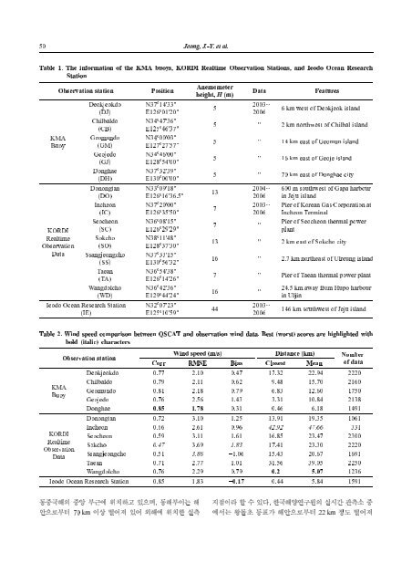
1. The information of the KMA buoys, KORDI Realtime Observation Stations, and Ieodo Ocean Research<br />
Table<br />
Station<br />
KMA<br />
Buoy<br />
KORDI<br />
Realtime<br />
Observation<br />
Data<br />
Deokjeokdo<br />
(DJ)<br />
Chilbaldo<br />
(CB)<br />
Geomundo<br />
(GM)<br />
Geojedo<br />
(GJ)<br />
Donghae<br />
(DH)<br />
Donongtan<br />
(DO)<br />
Incheon<br />
(IC)<br />
Seocheon<br />
(SC)<br />
Sokcho<br />
(SO)<br />
Ssangjeongcho<br />
(SS)<br />
Taean<br />
(TA)<br />
Wangdolcho<br />
(WD)<br />
Ocean Research Station<br />
Ieodo<br />
(IE)<br />
o 14'33"<br />
N37 o 01'20"<br />
E126<br />
o 47'36"<br />
N34 o 46'37"<br />
E125<br />
o 00'03"<br />
N34 o 27'57"<br />
E127<br />
o 46'00"<br />
N34 o 54'00"<br />
E128<br />
o 32'39"<br />
N37 o 00'00"<br />
E130<br />
o 09'18"<br />
N33 o 16'36.5"<br />
E126<br />
o 20'00"<br />
N37 o 35'50"<br />
E126<br />
o 08'15"<br />
N36 o 29'29"<br />
E126<br />
o 11'48"<br />
N38 o 37'30"<br />
E128<br />
o 33'15"<br />
N37 o 56'32"<br />
E130<br />
o 54'38"<br />
N36 o 14'26"<br />
E126<br />
o 42'36"<br />
N36 o 44'24"<br />
E129<br />
o 07'23"<br />
N32 o 10'59"<br />
E125<br />
Anemometer<br />
H (m)<br />
height,<br />
2003~<br />
2006<br />
2004~<br />
2006<br />
2003~<br />
2006<br />
2003~<br />
2006<br />
m southwest of Gapa harbour<br />
600<br />
Jeju island<br />
in<br />
of Korean Gas Corporation at<br />
Pier<br />
Terminal<br />
Incheon<br />
of Seocheon thermal power<br />
Pier<br />
plant<br />
km away from Hupo harbour<br />
24.5<br />
Uljin in<br />
2. Wind speed comparison between QSCAT and observation wind data. Best (worst) scores are highlighted with<br />
Table<br />
(italic) characters<br />
bold<br />
KMA<br />
Buoy<br />
KORDI<br />
Realtime<br />
Observation<br />
Data<br />
Observation station<br />
Wind speed (m/s) Distance (km) Number<br />
50 Jeong, J.-Y. et al.<br />
station<br />
Position<br />
Observation<br />
Features<br />
Data<br />
6 km west of Deokjeok island<br />
5<br />
5 '' 2 km northwest of Chilbal island<br />
5 '' 14 km east of Geomun island<br />
5 '' 16 km east of Geoje island<br />
5 '' 70 km east of Donghae city<br />
13<br />
7<br />
7 ''<br />
13 '' 2 km east of Sokcho city<br />
16 '' 2.7 km northeast of Ulreung island<br />
7 '' Pier of Taean thermal power plant<br />
16 ''<br />
44<br />
146 km southwest of Jeju island<br />
of data<br />
Corr RMSE Bias Closest Mean<br />
Deokjeokdo 0.77 2.10 0.47 17.32 22.94 2220<br />
Chilbaldo 0.79 2.11 0.62 9.48 15.70 2160<br />
Geomundo 0.81 2.18 0.79 6.83 12.60 1750<br />
Geojedo 0.76 2.56 1.43 3.31 10.84 2138<br />
Donghae 0.85 1.78 0.31 0.46 6.18 1491<br />
Donongtan 0.72 3.10 1.25 13.91 19.35 1061<br />
Incheon 0.66 2.61 0.96 42.92 47.66 331<br />
Seocheon 0.59 3.11 1.61 16.85 23.47 2300<br />
Sokcho 0.47 3.69 1.83 17.41 23.30 2220<br />
Ssangjeongcho 0.51 3.86 −1.06 15.43 20.67 1691<br />
Taean 0.71 2.77 1.01 31.56 39.05 2250<br />
Wangdolcho 0.76 2.29 0.79 0.20 5.07 1236<br />
Ieodo Ocean Research Station 0.85 1.83 −0.17 0.44 5.84 1591<br />
중앙 부근에 위치하고 있으며, 동해부이는 해<br />
동중국해의<br />
70 km 이상 떨어져 있어 외해에 위치한 실측<br />
안으로부터<br />
할 수 있다. 한국해양연구원의 실시간 관측소 중<br />
지점이라<br />
왕돌초 등표가 해안으로부터 22 km 정도 떨어져<br />
에서는