

GUIDE WAVE ANALYSIS AND FORECASTING - WMO
GUIDE WAVE ANALYSIS AND FORECASTING - WMO
GUIDE WAVE ANALYSIS AND FORECASTING - WMO

You also want an ePaper? Increase the reach of your titles
YUMPU automatically turns print PDFs into web optimized ePapers that Google loves.
20<br />
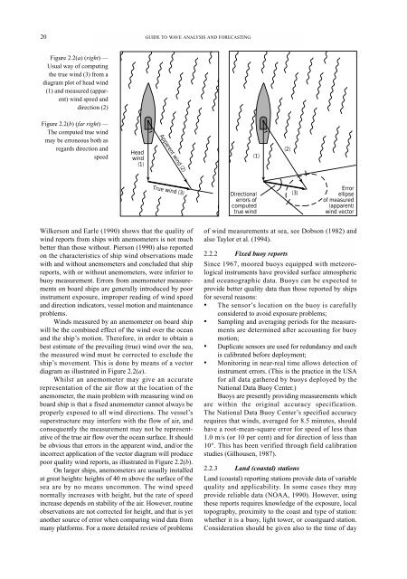
Figure 2.2(a) (right) —<br />
Usual way of computing<br />
the true wind (3) from a<br />
diagram plot of head wind<br />
(1) and measured (apparent)<br />
wind speed and<br />
direction (2)<br />
Figure 2.2(b) (far right) —<br />
The computed true wind<br />
may be erroneous both as<br />
regards direction and<br />
speed<br />
Head<br />
wind<br />
(1)<br />
Wilkerson and Earle (1990) shows that the quality of<br />
wind reports from ships with anemometers is not much<br />
better than those without. Pierson (1990) also reported<br />
on the characteristics of ship wind observations made<br />
with and without anemometers and concluded that ship<br />
reports, with or without anemometers, were inferior to<br />
buoy measurement. Errors from anemometer measurements<br />
on board ships are generally introduced by poor<br />
instrument exposure, improper reading of wind speed<br />
and direction indicators, vessel motion and maintenance<br />
problems.<br />
Winds measured by an anemometer on board ship<br />
will be the combined effect of the wind over the ocean<br />
and the ship’s motion. Therefore, in order to obtain a<br />
best estimate of the prevailing (true) wind over the sea,<br />
the measured wind must be corrected to exclude the<br />
ship’s movement. This is done by means of a vector<br />
diagram as illustrated in Figure 2.2(a).<br />
Whilst an anemometer may give an accurate<br />
representation of the air flow at the location of the<br />
anemometer, the main problem with measuring wind on<br />
board ship is that a fixed anemometer cannot always be<br />
properly exposed to all wind directions. The vessel’s<br />
superstructure may interfere with the flow of air, and<br />
consequently the measurement may not be representative<br />
of the true air flow over the ocean surface. It should<br />
be obvious that errors in the apparent wind, and/or the<br />
incorrect application of the vector diagram will produce<br />
poor quality wind reports, as illustrated in Figure 2.2(b).<br />
On larger ships, anemometers are usually installed<br />
at great heights: heights of 40 m above the surface of the<br />
sea are by no means uncommon. The wind speed<br />
normally increases with height, but the rate of speed<br />
increase depends on stability of the air. However, routine<br />
observations are not corrected for height, and that is yet<br />
another source of error when comparing wind data from<br />
many platforms. For a more detailed review of problems<br />
<strong>GUIDE</strong> TO <strong>WAVE</strong> <strong>ANALYSIS</strong> <strong>AND</strong> <strong>FORECASTING</strong><br />
True<br />
Apparent wind (2)<br />
w<br />
ind<br />
( 3)<br />
(1)<br />
Directional<br />
errors of<br />
computed<br />
true wind<br />
of wind measurements at sea, see Dobson (1982) and<br />
also Taylor et al. (1994).<br />
2.2.2 Fixed buoy reports<br />
Since 1967, moored buoys equipped with meteorological<br />
instruments have provided surface atmospheric<br />
and oceanographic data. Buoys can be expected to<br />
provide better quality data than those reported by ships<br />
for several reasons:<br />
• The sensor’s location on the buoy is carefully<br />
considered to avoid exposure problems;<br />
• Sampling and averaging periods for the measurements<br />
are determined after accounting for buoy<br />
motion;<br />
• Duplicate sensors are used for redundancy and each<br />
is calibrated before deployment;<br />
• Monitoring in near-real time allows detection of<br />
instrument errors. (This is the practice in the USA<br />
for all data gathered by buoys deployed by the<br />
National Data Buoy Center.)<br />
Buoys are presently providing measurements which<br />
are within the original accuracy specification.<br />
The National Data Buoy Center’s specified accuracy<br />
requires that winds, averaged for 8.5 minutes, should<br />
have a root-mean-square error for speed of less than<br />
1.0 m/s (or 10 per cent) and for direction of less than<br />
10°. This has been verified through field calibration<br />
studies (Gilhousen, 1987).<br />
2.2.3 Land (coastal) stations<br />
Land (coastal) reporting stations provide data of variable<br />
quality and applicability. In some cases they may<br />
provide reliable data (NOAA, 1990). However, using<br />
these reports requires knowledge of the exposure, local<br />
topography, proximity to the coast and type of station:<br />
whether it is a buoy, light tower, or coastguard station.<br />
Consideration should be given also to the time of day<br />
(2)<br />
(3)<br />
Error<br />
ellipse<br />
of measured<br />
(apparent)<br />
wind vector


