

Electronic Material Properties - und Geowissenschaften ...
Electronic Material Properties - und Geowissenschaften ...
Electronic Material Properties - und Geowissenschaften ...

You also want an ePaper? Increase the reach of your titles
YUMPU automatically turns print PDFs into web optimized ePapers that Google loves.
granite/gneiss basement rocks in the south and west are highly erodible due to deep<br />
weathering and low infiltration capacity, the overlying carbonate rocks outcropping in the<br />
north and east are less prone to erosion due to better soil structure and rapid infiltration<br />
in the karst system which prevents excessive overland flow (Fig. 2). Aro<strong>und</strong> the lake of<br />
Lagoa Santa, the Neoproterozoic carbonate rocks are overlain by siltite rocks with a<br />
very low infiltration capacity and weak soil and saprolite cohesion. In these highly<br />
vulnerable hills, many gullies can be observed already, most but not all of them related<br />
to urban areas. On the mountain tops in the middle of the study area, laterite crusts<br />
protect the <strong>und</strong>erlying soils from erosion and thus these areas are assigned low<br />
erodibility values.<br />
Fig. 2: Erosivity of the study area, based on<br />
lithology and the existence of laterite crusts.<br />
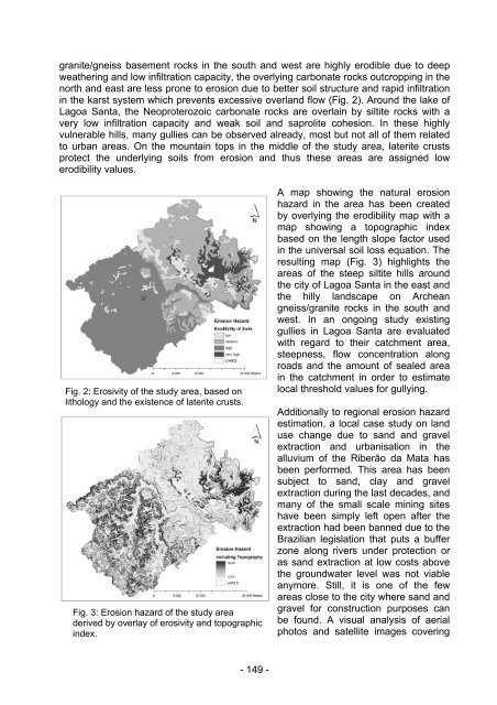
Fig. 3: Erosion hazard of the study area<br />
derived by overlay of erosivity and topographic<br />
index.<br />
- 149 -<br />
A map showing the natural erosion<br />
hazard in the area has been created<br />
by overlying the erodibility map with a<br />
map showing a topographic index<br />
based on the length slope factor used<br />
in the universal soil loss equation. The<br />
resulting map (Fig. 3) highlights the<br />
areas of the steep siltite hills aro<strong>und</strong><br />
the city of Lagoa Santa in the east and<br />
the hilly landscape on Archean<br />
gneiss/granite rocks in the south and<br />
west. In an ongoing study existing<br />
gullies in Lagoa Santa are evaluated<br />
with regard to their catchment area,<br />
steepness, flow concentration along<br />
roads and the amount of sealed area<br />
in the catchment in order to estimate<br />
local threshold values for gullying.<br />
Additionally to regional erosion hazard<br />
estimation, a local case study on land<br />
use change due to sand and gravel<br />
extraction and urbanisation in the<br />
alluvium of the Riberão da Mata has<br />
been performed. This area has been<br />
subject to sand, clay and gravel<br />
extraction during the last decades, and<br />
many of the small scale mining sites<br />
have been simply left open after the<br />
extraction had been banned due to the<br />
Brazilian legislation that puts a buffer<br />
zone along rivers <strong>und</strong>er protection or<br />
as sand extraction at low costs above<br />
the gro<strong>und</strong>water level was not viable<br />
anymore. Still, it is one of the few<br />
areas close to the city where sand and<br />
gravel for construction purposes can<br />
be fo<strong>und</strong>. A visual analysis of aerial<br />
photos and satellite images covering