Scientific and Technical Aerospace Reports Volume 39 April 6, 2001
Scientific and Technical Aerospace Reports Volume 39 April 6, 2001
Scientific and Technical Aerospace Reports Volume 39 April 6, 2001
Create successful ePaper yourself
Turn your PDF publications into a flip-book with our unique Google optimized e-Paper software.
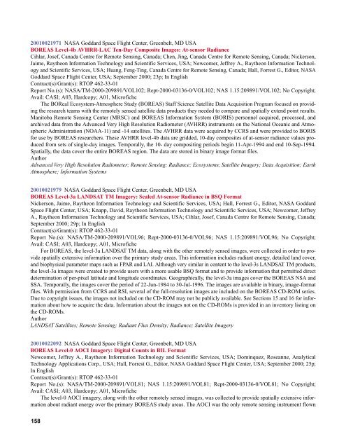
<strong>2001</strong>0021971 NASA Goddard Space Flight Center, Greenbelt, MD USA<br />
BOREAS Level-4b AVHRR-LAC Ten-Day Composite Images: At-sensor Radiance<br />
Cihlar, Josef, Canada Centre for Remote Sensing, Canada; Chen, Jing, Canada Centre for Remote Sensing, Canada; Nickerson,<br />
Jaime, Raytheon Information Technology <strong>and</strong> <strong>Scientific</strong> Services, USA; Newcomer, Jeffrey A., Raytheon Information Technology<br />
<strong>and</strong> <strong>Scientific</strong> Services, USA; Huang, Feng-Ting, Canada Centre for Remote Sensing, Canada; Hall, Forrest G., Editor, NASA<br />
Goddard Space Flight Center, USA; September 2000; 23p; In English<br />
Contract(s)/Grant(s): RTOP 462-33-01<br />
Report No.(s): NASA/TM-2000-209891/VOL102; Rept-2000-03136-0/VOL102; NAS 1.15:209891/VOL102; No Copyright;<br />
Avail: CASI; A03, Hardcopy; A01, Microfiche<br />
The BOReal Ecosystem-Atmosphere Study (BOREAS) Staff Science Satellite Data Acquisition Program focused on providing<br />
the research teams with the remotely sensed satellite data products they needed to compare <strong>and</strong> spatially extend point results.<br />
Manitoba Remote Sensing Center (MRSC) <strong>and</strong> BOREAS Information System (BORIS) personnel acquired, processed, <strong>and</strong><br />
archived data from the Advanced Very High Resolution Radiometer (AVHRR) instruments on the National Oceanic <strong>and</strong> Atmospheric<br />
Administration (NOAA-11) <strong>and</strong> -14 satellites. The AVHRR data were acquired by CCRS <strong>and</strong> were provided to BORIS<br />
for use by BOREAS researchers. These AVHRR level-4b data are gridded, 10-day composites of at-sensor radiance values produced<br />
from sets of single-day images. Temporally, the 10- day compositing periods begin 11-Apr-1994 <strong>and</strong> end 10-Sep-1994.<br />
Spatially, the data cover the entire BOREAS region. The data are stored in binary image format files.<br />
Author<br />
Advanced Very High Resolution Radiometer; Remote Sensing; Radiance; Ecosystems; Satellite Imagery; Data Acquisition; Earth<br />
Atmosphere; Information Systems<br />
<strong>2001</strong>0021979 NASA Goddard Space Flight Center, Greenbelt, MD USA<br />
BOREAS Level-3a LANDSAT TM Imagery: Scaled At-sensor Radiance in BSQ Format<br />
Nickerson, Jaime, Raytheon Information Technology <strong>and</strong> <strong>Scientific</strong> Services, USA; Hall, Forrest G., Editor, NASA Goddard<br />
Space Flight Center, USA; Knapp, David, Raytheon Information Technology <strong>and</strong> <strong>Scientific</strong> Services, USA; Newcomer, Jeffrey<br />
A., Raytheon Information Technology <strong>and</strong> <strong>Scientific</strong> Services, USA; Cihlar, Josef, Canada Centre for Remote Sensing, Canada;<br />
September 2000; 29p; In English<br />
Contract(s)/Grant(s): RTOP 462-33-01<br />
Report No.(s): NASA/TM-2000-209891/VOL96; Rept-2000-03136-0/VOL96; NAS 1.15:209891/VOL96; No Copyright;<br />
Avail: CASI; A03, Hardcopy; A01, Microfiche<br />
For BOREAS, the level-3a LANDSAT TM data, along with the other remotely sensed images, were collected in order to provide<br />
spatially extensive information over the primary study areas. This information includes radiant energy, detailed l<strong>and</strong> cover,<br />
<strong>and</strong> biophysical parameter maps such as FPAR <strong>and</strong> LAI. Although very similar in content to the level-3s LANDSAT TM products,<br />
the level-3a images were created to provide users with a more usable BSQ format <strong>and</strong> to provide information that permitted direct<br />
determination of per-pixel latitude <strong>and</strong> longitude coordinates. Geographically, the level-3a images cover the BOREAS NSA <strong>and</strong><br />
SSA. Temporally, the images cover the period of 22-Jun-1984 to 30-Jul-1996. The images are available in binary, image-format<br />
files. With permission from CCRS <strong>and</strong> RSI, several of the full-resolution images are included on the BOREAS CD-ROM series.<br />
Due to copyright issues, the images not included on the CD-ROM may not be publicly available. See Sections 15 <strong>and</strong> 16 for information<br />
about how to acquire the data. Information about the images not on the CD-ROMs is provided in an inventory listing on<br />
the CD-ROMs.<br />
Author<br />
LANDSAT Satellites; Remote Sensing; Radiant Flux Density; Radiance; Satellite Imagery<br />
<strong>2001</strong>0022092 NASA Goddard Space Flight Center, Greenbelt, MD USA<br />
BOREAS Level-0 AOCI Imagery: Digital Counts in BIL Format<br />
Newcomer, Jeffrey A., Raytheon Information Technology <strong>and</strong> <strong>Scientific</strong> Services, USA; Dominquez, Roseanne, Analytical<br />
Technology Applications Corp., USA; Hall, Forrest G., Editor, NASA Goddard Space Flight Center, USA; September 2000; 25p;<br />
In English<br />
Contract(s)/Grant(s): RTOP 462-33-01<br />
Report No.(s): NASA/TM-2000-209891/VOL81; NAS 1.15:209891/VOL81; Rept-2000-03136-0/VOL81; No Copyright;<br />
Avail: CASI; A03, Hardcopy; A01, Microfiche<br />
The level-0 AOCI imagery, along with the other remotely sensed images, was collected to provide spatially extensive information<br />
about radiant energy over the primary BOREAS study areas. The AOCI was the only remote sensing instrument flown<br />
158


