Scientific and Technical Aerospace Reports Volume 39 April 6, 2001
Scientific and Technical Aerospace Reports Volume 39 April 6, 2001
Scientific and Technical Aerospace Reports Volume 39 April 6, 2001
You also want an ePaper? Increase the reach of your titles
YUMPU automatically turns print PDFs into web optimized ePapers that Google loves.
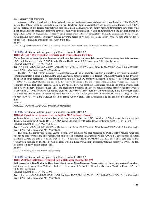
A03, Hardcopy; A01, Microfiche<br />
Canadian AES personnel collected data related to surface <strong>and</strong> atmospheric meteorological conditions over the BOREAS<br />
region. This data set contains 15-minute meteorological data from 14 automated meteorology stations located across the BOREAS<br />
region. Included in this data are parameters of date, time, mean sea level pressure, station pressure, temperature, dew point, wind<br />
speed, resultant wind speed, resultant wind direction, peak wind, precipitation, maximum temperature in the last hour, minimum<br />
temperature in the last hour, pressure tendency, liquid precipitation in the last hour, relative humidity, precipitation from a weighing<br />
gauge, <strong>and</strong> snow depth. Temporally, the data cover the period of August 1993 to December 1996. The data are provided in<br />
tabular ASCII files, <strong>and</strong> are classified as AFM-Staff data.<br />
Author<br />
Meteorological Parameters; Data Acquisition; Humidity; Dew Point; Surface Properties; Wind Direction<br />
<strong>2001</strong>0022164 NASA Goddard Space Flight Center, Greenbelt, MD USA<br />
BOREAS TGB-7 Dry Deposition Herbicide <strong>and</strong> Organochlorine Flux Data<br />
Waite, Don, Environment Canada, Canada; Conrad, Sara K., Editor, Raytheon Information Technology <strong>and</strong> <strong>Scientific</strong> Services,<br />
USA; Hall, Forrest G., Editor, NASA Goddard Space Flight Center, USA; November 2000; 22p; In English<br />
Contract(s)/Grant(s): RTOP 923-462-33-01<br />
Report No.(s): NASA/TM-2000-209891/VOL235; Rept-2000-03136-0/VOL235; NAS 1.15:209891/VOL235; No Copyright;<br />
Avail: CASI; A03, Hardcopy; A01, Microfiche<br />
The BOREAS TGB-7 team measured the concentration <strong>and</strong> flux of several agricultural pesticides in air, rainwater, <strong>and</strong> dry<br />
deposition samples in order to determine the associated yearly deposition rates. This data set contains information on the dry deposition<br />
flux of seven herbicides [2,4- dichlorophenoxyacidic_acid (2,4-D), bromoxynil, dicamb, 2-methyl-4-chlorophenoxyacetic<br />
acid (MCPA), triallate, trifluralin, <strong>and</strong> diclop-methyl] known to appear in the atmosphere of the Canadian prairies. Also, the concentration<br />
of three herbicides (atrazine, alachlor, <strong>and</strong> metolachlor), two groups of insecticides (lindane <strong>and</strong> breakdown products<br />
<strong>and</strong> dichloro-diphenyl-trichloroethane (DDT) <strong>and</strong> breakdown products), <strong>and</strong> several polychlorinated biphenyls commonly used<br />
in the central USA was measured. All of these chemicals are reported, in the literature, to be transported in the atmosphere. Many<br />
have been reported to occur in boreal <strong>and</strong> arctic food chains. The sampling was carried out from 16-Jun to 13-Aug-1993 <strong>and</strong><br />
04-May to 20-Jul-1994 at the BOREAS site in the Prince Albert National Park (Waskesiu). The data are stored in tabular ASCII<br />
files.<br />
Author<br />
Pesticides; Diphenyl Compounds; Deposition; Herbicides<br />
<strong>2001</strong>0022165 NASA Goddard Space Flight Center, Greenbelt, MD USA<br />
BOREAS Forest Cover Data Layers over the SSA-MSA in Raster Format<br />
Nickeson, Jaime, Raytheon Information Technology <strong>and</strong> <strong>Scientific</strong> Services, USA; Gruszka, F, SASkatchewan Environment <strong>and</strong><br />
Resource Management, Canada; Hall, F., NASA Goddard Space Flight Center, USA; September 2000; 21p; In English<br />
Contract(s)/Grant(s): RTOP 923-462-33-01<br />
Report No.(s): NASA/TM-2000-209891/VOL113; Rept-2000-03136-0/VOL113; NAS 1.15:209891/VOL113; No Copyright;<br />
Avail: CASI; A03, Hardcopy; A01, Microfiche<br />
This data set, originally provided as vector polygons with attributes, has been processed by BORIS staff to provide raster files<br />
that can be used for modeling or for comparison purposes. The original data were received as ARC/INFO coverages or as export<br />
files from SERM. The data include information on forest parameters for the BOREAS SSA-MSA. Most of the data used for this<br />
product were acquired by BORIS in 1993; the maps were produced from aerial photography taken as recently as 1988. The data<br />
are stored in binary, image format files.<br />
Author<br />
Data Acquisition; Forests; Aerial Photography<br />
<strong>2001</strong>0022166 NASA Goddard Space Flight Center, Greenbelt, MD USA<br />
BOREAS RSS-3 Reflectance Measured from a Helicopter-Mounted SE-590<br />
Hall, Forrest G., Editor, NASA Goddard Space Flight Center, USA; Nickeson, Jaime, Editor, Raytheon Information Technology<br />
<strong>and</strong> <strong>Scientific</strong> Services, USA; Walthall, Charles L., Department of Agriculture, USA; Loechel, Sara, Maryl<strong>and</strong> Univ., USA; July<br />
2000; 32p; In English<br />
Contract(s)/Grant(s): RTOP 462-33-01<br />
Report No.(s): NASA/TM-2000-209891/VOL47; Rept-2000-03136-0/VOL47; NAS 1.15:209891/VOL47; No Copyright;<br />
Avail: CASI; A03, Hardcopy; A01, Microfiche<br />
165


