Session 1 - Montefiore
Session 1 - Montefiore
Session 1 - Montefiore

Create successful ePaper yourself
Turn your PDF publications into a flip-book with our unique Google optimized e-Paper software.
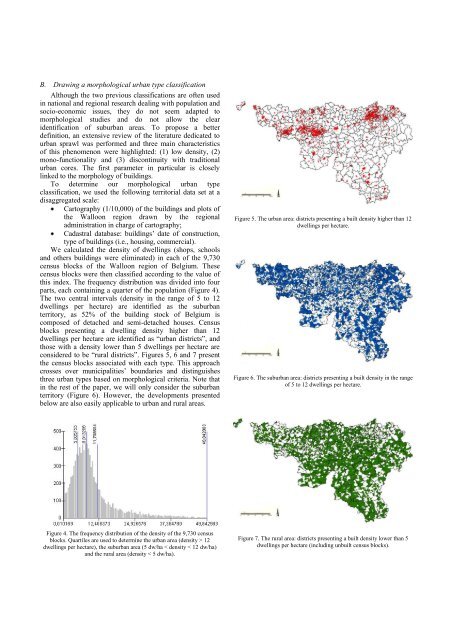
B. Drawing a morphological urban type classification<br />
Although the two previous classifications are often used<br />
in national and regional research dealing with population and<br />
socio-economic issues, they do not seem adapted to<br />
morphological studies and do not allow the clear<br />
identification of suburban areas. To propose a better<br />
definition, an extensive review of the literature dedicated to<br />
urban sprawl was performed and three main characteristics<br />
of this phenomenon were highlighted: (1) low density, (2)<br />
mono-functionality and (3) discontinuity with traditional<br />
urban cores. The first parameter in particular is closely<br />
linked to the morphology of buildings.<br />
To determine our morphological urban type<br />
classification, we used the following territorial data set at a<br />
disaggregated scale:<br />
Cartography (1/10,000) of the buildings and plots of<br />
the Walloon region drawn by the regional<br />
administration in charge of cartography;<br />
Cadastral database: buildings’ date of construction,<br />
type of buildings (i.e., housing, commercial).<br />
We calculated the density of dwellings (shops, schools<br />
and others buildings were eliminated) in each of the 9,730<br />
census blocks of the Walloon region of Belgium. These<br />
census blocks were then classified according to the value of<br />
this index. The frequency distribution was divided into four<br />
parts, each containing a quarter of the population (Figure 4).<br />
The two central intervals (density in the range of 5 to 12<br />
dwellings per hectare) are identified as the suburban<br />
territory, as 52% of the building stock of Belgium is<br />
composed of detached and semi-detached houses. Census<br />
blocks presenting a dwelling density higher than 12<br />
dwellings per hectare are identified as “urban districts”, and<br />
those with a density lower than 5 dwellings per hectare are<br />
considered to be “rural districts”. Figures 5, 6 and 7 present<br />
the census blocks associated with each type. This approach<br />
crosses over municipalities’ boundaries and distinguishes<br />
three urban types based on morphological criteria. Note that<br />
in the rest of the paper, we will only consider the suburban<br />
territory (Figure 6). However, the developments presented<br />
below are also easily applicable to urban and rural areas.<br />
Figure 4. The frequency distribution of the density of the 9,730 census<br />
blocks. Quartiles are used to determine the urban area (density > 12<br />
dwellings per hectare), the suburban area (5 dw/ha < density < 12 dw/ha)<br />
and the rural area (density < 5 dw/ha).<br />
Figure 5. The urban area: districts presenting a built density higher than 12<br />
dwellings per hectare.<br />
Figure 6. The suburban area: districts presenting a built density in the range<br />
of 5 to 12 dwellings per hectare.<br />
Figure 7. The rural area: districts presenting a built density lower than 5<br />
dwellings per hectare (including unbuilt census blocks).