Session 1 - Montefiore
Session 1 - Montefiore
Session 1 - Montefiore

Create successful ePaper yourself
Turn your PDF publications into a flip-book with our unique Google optimized e-Paper software.
22<br />
The drivers of urban sprawl<br />
Box 3 Dublin metropolitan area: rapidly growing economy and population<br />
Dublin is a relatively small city by European and international standards. However, it dominates the<br />
urban pattern of Ireland in terms of demography, employment and enterprise (Bannon, 2000). The<br />
Greater Dublin metropolitan area population was 1 535 000 in 2002, 40 % of the total Irish population.<br />
The National Spatial Strategy (2002) suggests that by 2020 the Greater Dublin area population will be<br />
in the range of 1.9–2.2 million. The strong growth of the Greater Dublin is a result of the region's role<br />
both within Ireland and as a European capital city. Consequently, the Greater Dublin area will need to<br />
accommodate 403 000–480 000 additional inhabitants by the year 2020.<br />
Population growth and economic development, as well as house type and price, are predicted to be the<br />
main drivers of land use change in the Greater Dublin area during the coming decades. High house prices<br />
in Dublin are a significant push factor driving the population towards the rural fringes of the city where it<br />
is cheaper to buy or build a house. Another push factor is the small size of apartments in the city centre,<br />
forcing families with children needing more space to move out of the city where houses prices are lower<br />
and housing more affordable. Personal housing preferences also play an important role as rural living is the<br />
Irish housing ideal (Michell, 2004). This preference is realised in single-family houses in open countryside<br />
with the benefits of the proximity to the capital or other urban areas. The realisation of this ideal is greatly<br />
facilitated by the planning regime which imposes few constraints on the conversion of agricultural areas to<br />
low-density housing areas.<br />
Urban–rural migration in the Greater Dublin area has led to the growth of rural towns and villages at the<br />
expense of the City of Dublin. The growth of residential areas appears to follow the line of road and rail<br />
transport, suggesting a preference for rural living but with the benefits of proximity to urban areas including<br />
employment. Another push factor is the transport system in Dublin. Commuting times are long and the lack<br />
of orbital roads and rail networks means that to get from one side of the city to the other necessitates a<br />
journey through the centre. Often it is quicker to commute from outside Dublin to the centre rather than<br />
from one side to the other (Gkartzios and Scott, 2005).<br />
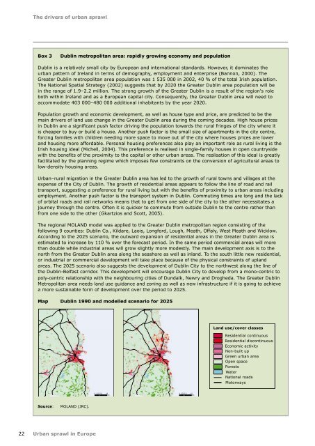
The regional MOLAND model was applied to the Greater Dublin metropolitan region consisting of the<br />
following 9 counties: Dublin Co., Kildare, Laois, Longford, Lough, Meath, Offaly, West Meath and Wicklow.<br />
According to the 2025 scenario, the outward expansion of residential areas in the Greater Dublin area is<br />
estimated to increase by 110 % over the forecast period. In the same period commercial areas will more<br />
than double while industrial areas will grow slightly more modestly. The main development axis is to the<br />
north from the Greater Dublin area along the seashore as well as inland. To the south little new residential,<br />
or industrial or commercial development will take place because of the physical constraints of upland<br />
areas. The 2025 scenario also suggests the development of Dublin City to the northwest along the line of<br />
the Dublin-Belfast corridor. This development will encourage Dublin City to develop from a mono-centric to<br />
poly-centric relationship with the neighbouring cities of Dundalk, Newry and Drogheda. The Greater Dublin<br />
Metropolitan area needs land use guidance and zoning as well as new infrastructure if it is going to achieve<br />
a more sustainable form of development over the period to 2025.<br />
Map Dublin 1990 and modelled scenario for 2025<br />
Source: MOLAND (JRC).<br />
Urban sprawl in Europe<br />
0 3.75 7.5 15<br />
Km<br />
0 3.75 7.5 15<br />
Km<br />
Land use/cover classes<br />
Residential continuous<br />
Residential discontinuous<br />
Economic activity<br />
Non-built up<br />
Green urban area<br />
Open space<br />
Forests<br />
Water<br />
National roads<br />
Motorways