
You also want an ePaper? Increase the reach of your titles
YUMPU automatically turns print PDFs into web optimized ePapers that Google loves.
GNGTS 2009 SESSIONE <strong>2.3</strong><br />
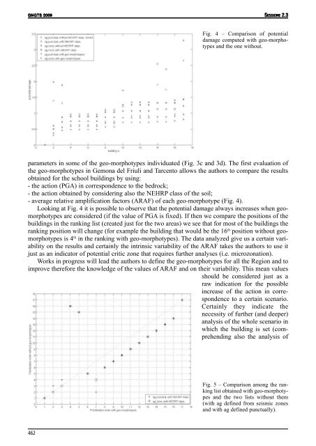
Fig. 4 – Comparison of potential<br />
damage computed with geo-morphotypes<br />
and the one without.<br />
parameters in some of the geo-morphotypes individuated (Fig. 3c and 3d). The first evaluation of<br />
the geo-morphotypes in Gemona del Friuli and Tarcento allows the authors to compare the results<br />
obtained for the school buildings by using:<br />
- the action (PGA) in correspondence to the bedrock;<br />
- the action obtained by considering also the NEHRP class of the soil;<br />
- average relative amplification factors (ARAF) of each geo-morphotype (Fig. 4).<br />
Looking at Fig. 4 it is possible to observe that the potential damage always increases when geomorphotypes<br />
are considered (if the value of PGA is fixed). If then we compare the positions of the<br />
buildings in the ranking list (created just for the two areas) we see that for most of the buildings the<br />
ranking position will change (for example the building that would be the 16 th position without geomorphotypes<br />
is 4 th in the ranking with geo-morphotypes). The data analyzed give us a certain variability<br />
on the results and certainly the intrinsic variability of the ARAF takes the authors to use it<br />
just as an indicator of potential critic zone that requires further analyses (i.e. microzonation).<br />
Works in progress will lead the authors to define the geo-morphotypes for all the Region and to<br />
improve therefore the knowledge of the values of ARAF and on their variability. This mean values<br />
should be considered just as a<br />
raw indication for the possible<br />
increase of the action in correspondence<br />
to a certain scenario.<br />
Certainly they indicate the<br />
necessity of further (and deeper)<br />
analysis of the whole scenario in<br />
which the building is set (comprehending<br />
also the analysis of<br />
Fig. 5 – Comparison among the ranking<br />
list obtained with geo-morphotypes<br />
and the two lists without them<br />
(with ag defined from seismic zones<br />
and with ag defined punctually).<br />
462