- Page 1 and 2:
Edited with the trial version of Fo
- Page 3 and 4:
ISEM2016, 3 rd International Sympos
- Page 5 and 6:
M.YILDIRIM / ISEM2016 Alanya - Turk
- Page 7 and 8:
M.YILDIRIM / ISEM2016 Alanya - Turk
- Page 9 and 10:
M.YILDIRIM / ISEM2016 Alanya - Turk
- Page 11 and 12:
B. TAŞKAN et al./ ISEM2016 Alanya
- Page 13 and 14:
B. TAŞKAN et al./ ISEM2016 Alanya
- Page 15 and 16:
B. TAŞKAN et al./ ISEM2016 Alanya
- Page 17 and 18:
B. TAŞKAN et al./ ISEM2016 Alanya
- Page 19 and 20:
B. TAŞKAN et al./ ISEM2016 Alanya
- Page 21 and 22:
S. MALKOC./ ISEM2016 Alanya - Turke
- Page 23 and 24:
S. MALKOC./ ISEM2016 Alanya - Turke
- Page 25 and 26:
S. MALKOC./ ISEM2016 Alanya - Turke
- Page 27 and 28:
S. MALKOC./ ISEM2016 Alanya - Turke
- Page 29 and 30:
ISEM2016, 3 rd International Sympos
- Page 31 and 32:
ISEM2016, 3 rd International Sympos
- Page 33 and 34:
ISEM2016, 3 rd International Sympos
- Page 35 and 36:
ISEM2016, 3 rd International Sympos
- Page 37 and 38:
N. CALISKAN et al./ ISEM2016 Alanya
- Page 39 and 40:
N. CALISKAN et al./ ISEM2016 Alanya
- Page 41 and 42:
N. CALISKAN et al./ ISEM2016 Alanya
- Page 43 and 44:
N. CALISKAN et al./ ISEM2016 Alanya
- Page 45 and 46:
Canoğlu and Kurtuluş / ISEM2016 A
- Page 47 and 48:
Canoğlu and Kurtuluş / ISEM2016 A
- Page 49 and 50:
Canoğlu and Kurtuluş / ISEM2016 A
- Page 51 and 52:
Canoğlu and Kurtuluş / ISEM2016 A
- Page 53 and 54:
Canoğlu and Kurtuluş / ISEM2016 A
- Page 55 and 56:
ISEM2016, 3 rd International Sympos
- Page 57 and 58:
A.CALISKAN and A.ONAT / ISEM2016 Al
- Page 59 and 60:
A.CALISKAN and A.ONAT / ISEM2016 Al
- Page 61 and 62:
A.CALISKAN and A.ONAT / ISEM2016 Al
- Page 63 and 64:
A.CALISKAN and A.ONAT / ISEM2016 Al
- Page 65 and 66:
ISEM2016, 3 rd International Sympos
- Page 67 and 68:
H. AKYUZ / ISEM2016 Alanya - Turkey
- Page 69 and 70:
H. AKYUZ / ISEM2016 Alanya - Turkey
- Page 71 and 72:
H. AKYUZ / ISEM2016 Alanya - Turkey
- Page 73 and 74:
H. AKYUZ / ISEM2016 Alanya - Turkey
- Page 75 and 76:
ISEM2016, 3 rd International Sympos
- Page 77 and 78:
K. ARTUC / ISEM2016 Alanya - Turkey
- Page 79 and 80:
K. ARTUC / ISEM2016 Alanya - Turkey
- Page 81 and 82:
K. ARTUC / ISEM2016 Alanya - Turkey
- Page 83 and 84:
K. ARTUC / ISEM2016 Alanya - Turkey
- Page 85 and 86:
K. ARTUC / ISEM2016 Alanya - Turkey
- Page 87 and 88:
K. ARTUC / ISEM2016 Alanya - Turkey
- Page 89 and 90:
K. ARTUC / ISEM2016 Alanya - Turkey
- Page 91 and 92:
K. ARTUC / ISEM2016 Alanya - Turkey
- Page 93 and 94:
K. ARTUC / ISEM2016 Alanya - Turkey
- Page 95 and 96:
O. MUTLUEL / ISEM2016 Alanya - Turk
- Page 97 and 98:
O. MUTLUEL / ISEM2016 Alanya - Turk
- Page 99 and 100:
O. MUTLUEL / ISEM2016 Alanya - Turk
- Page 101 and 102:
S. KAYA / ISEM2016 Alanya - Turkey
- Page 103 and 104:
S. KAYA / ISEM2016 Alanya - Turkey
- Page 105 and 106:
S. KAYA / ISEM2016 Alanya - Turkey
- Page 107 and 108:
S. KAYA / ISEM2016 Alanya - Turkey
- Page 109 and 110:
DİN EĞİTİMİNDE DOĞAL MATERYAL
- Page 111 and 112:
Çevremiz insanın yaşamının ba
- Page 113 and 114:
Klinberg, 630 çocuğa “Tanrıyı
- Page 115 and 116:
İnsanların bunlardan ibret almala
- Page 117 and 118:
ir zemin bulmasına yardımcı olac
- Page 119 and 120:
değer yüklü olan dünya veya dah
- Page 121 and 122:
hedeflemektedir. Bunu gerçekleşti
- Page 123 and 124:
ISEM2016, 3 rd International Sympos
- Page 125 and 126:
Y. AKYUZ / ISEM2016 Alanya - Turkey
- Page 127 and 128:
Y. AKYUZ / ISEM2016 Alanya - Turkey
- Page 129 and 130:
Y. AKYUZ / ISEM2016 Alanya - Turkey
- Page 131 and 132:
ISEM2016, 3 rd International Sympos
- Page 133 and 134:
G. BEYHAN et al./ ISEM2016 Alanya -
- Page 135 and 136:
G. BEYHAN et al./ ISEM2016 Alanya -
- Page 137 and 138:
G. BEYHAN et al./ ISEM2016 Alanya -
- Page 139 and 140:
G. BEYHAN et al./ ISEM2016 Alanya -
- Page 141 and 142:
ISEM2016, 3 rd International Sympos
- Page 143 and 144:
R. CAVUSOGLU / ISEM2016 Alanya - Tu
- Page 145 and 146:
R. CAVUSOGLU / ISEM2016 Alanya - Tu
- Page 147 and 148:
R. CAVUSOGLU / ISEM2016 Alanya - Tu
- Page 149 and 150:
R. CAVUSOGLU / ISEM2016 Alanya - Tu
- Page 151 and 152:
R. CAVUSOGLU / ISEM2016 Alanya - Tu
- Page 153 and 154:
R. CAVUSOGLU / ISEM2016 Alanya - Tu
- Page 155 and 156:
ISEM2016, 3 rd International Sympos
- Page 157 and 158:
S.BEYHAN et al./ ISEM2016 Alanya -
- Page 159 and 160:
S.BEYHAN et al./ ISEM2016 Alanya -
- Page 161 and 162:
S.BEYHAN et al./ ISEM2016 Alanya -
- Page 163 and 164:
S.BEYHAN et al./ ISEM2016 Alanya -
- Page 165 and 166:
ISEM2016, 3 rd International Sympos
- Page 167 and 168:
N. CAGLAR et al./ ISEM2016 Alanya -
- Page 169 and 170:
N. CAGLAR et al./ ISEM2016 Alanya -
- Page 171 and 172:
N. CAGLAR et al./ ISEM2016 Alanya -
- Page 173 and 174:
ISEM2016, 3 rd International Sympos
- Page 175 and 176:
A. ARIFJANOV et al./ ISEM2016 Alany
- Page 177 and 178:
A. ARIFJANOV et al./ ISEM2016 Alany
- Page 179 and 180:
A. ARIFJANOV et al./ ISEM2016 Alany
- Page 181 and 182:
C.FİDAN et al./ ISEM2016 Alanya -
- Page 183 and 184:
C.FİDAN et al./ ISEM2016 Alanya -
- Page 185 and 186:
C.FİDAN et al./ ISEM2016 Alanya -
- Page 187 and 188:
C.FİDAN et al./ ISEM2016 Alanya -
- Page 189 and 190:
C.FİDAN et al./ ISEM2016 Alanya -
- Page 191 and 192:
B.DURKAYA et al./ ISEM2016 Alanya -
- Page 193 and 194:
B.DURKAYA et al./ ISEM2016 Alanya -
- Page 195 and 196:
B.DURKAYA et al./ ISEM2016 Alanya -
- Page 197 and 198:
B.DURKAYA et al./ ISEM2016 Alanya -
- Page 199 and 200:
D.A. YILDIRIM / ISEM2016 Alanya - T
- Page 201 and 202:
D.A. YILDIRIM / ISEM2016 Alanya - T
- Page 203 and 204:
D.A. YILDIRIM / ISEM2016 Alanya - T
- Page 205 and 206:
D.A. YILDIRIM / ISEM2016 Alanya - T
- Page 207 and 208:
ISEM2016, 3 rd International Sympos
- Page 209 and 210:
A.SÖZEN ve diğ. / ISEM2016 Alanya
- Page 211 and 212:
A.SÖZEN ve diğ. / ISEM2016 Alanya
- Page 213 and 214:
A.SÖZEN ve diğ. / ISEM2016 Alanya
- Page 215 and 216:
A.SÖZEN ve diğ. / ISEM2016 Alanya
- Page 217 and 218:
N. CAGLAR et al./ ISEM2016 Alanya -
- Page 219 and 220:
N. CAGLAR et al./ ISEM2016 Alanya -
- Page 221 and 222:
N. CAGLAR et al./ ISEM2016 Alanya -
- Page 223 and 224:
ISEM2016, 3 rd International Sympos
- Page 225 and 226:
A.DURKAYA et al./ ISEM2016 Alanya -
- Page 227 and 228:
A.DURKAYA et al./ ISEM2016 Alanya -
- Page 229 and 230:
A.DURKAYA et al./ ISEM2016 Alanya -
- Page 231 and 232:
H.I.SENAVCU/ ISEM2016 Alanya - Turk
- Page 233 and 234:
H.I.SENAVCU/ ISEM2016 Alanya - Turk
- Page 235 and 236:
H.I.SENAVCU/ ISEM2016 Alanya - Turk
- Page 237 and 238:
H.I.SENAVCU/ ISEM2016 Alanya - Turk
- Page 239 and 240:
H.I.SENAVCU/ ISEM2016 Alanya - Turk
- Page 241 and 242:
G.GENÇAY et al./ ISEM2016 Alanya -
- Page 243 and 244:
G.GENÇAY et al./ ISEM2016 Alanya -
- Page 245 and 246:
G.GENÇAY et al./ ISEM2016 Alanya -
- Page 247 and 248:
G.GENÇAY et al./ ISEM2016 Alanya -
- Page 249 and 250:
G.GENÇAY et al./ ISEM2016 Alanya -
- Page 251 and 252:
ISEM2016, 3 rd International Sympos
- Page 253 and 254:
E. DÖNMEZ et al./ ISEM2016 Alanya
- Page 255 and 256:
E. DÖNMEZ et al./ ISEM2016 Alanya
- Page 257 and 258:
E. DÖNMEZ et al./ ISEM2016 Alanya
- Page 259 and 260:
E. DÖNMEZ et al./ ISEM2016 Alanya
- Page 261 and 262:
ISEM2016, 3 rd International Sympos
- Page 263 and 264:
N. DEĞİRMEN et al./ ISEM2016 Alan
- Page 265 and 266:
N. DEĞİRMEN et al./ ISEM2016 Alan
- Page 267 and 268:
N. DEĞİRMEN et al./ ISEM2016 Alan
- Page 269 and 270:
ISEM2016, 3 rd International Sympos
- Page 271 and 272:
E.KESEBİR/ ISEM2016 Alanya - Turke
- Page 273 and 274:
E.KESEBİR/ ISEM2016 Alanya - Turke
- Page 275 and 276:
E.KESEBİR/ ISEM2016 Alanya - Turke
- Page 277 and 278:
E.KESEBİR/ ISEM2016 Alanya - Turke
- Page 279 and 280:
E.KESEBİR/ ISEM2016 Alanya - Turke
- Page 281 and 282:
ISEM2016, 3 rd International Sympos
- Page 283 and 284:
E. HACIMÜFTÜOĞLU / ISEM2016 Alan
- Page 285 and 286:
ۚ E. HACIMÜFTÜOĞLU / ISEM2016 A
- Page 287 and 288:
E. HACIMÜFTÜOĞLU / ISEM2016 Alan
- Page 289 and 290:
E. HACIMÜFTÜOĞLU / ISEM2016 Alan
- Page 291 and 292:
ISEM2016, 3 rd International Sympos
- Page 293 and 294:
S.YAVUZ / ./ ISEM2016 Alanya - Turk
- Page 295 and 296:
S.YAVUZ / ./ ISEM2016 Alanya - Turk
- Page 297 and 298:
S.YAVUZ / ./ ISEM2016 Alanya - Turk
- Page 299 and 300:
S.YAVUZ / ./ ISEM2016 Alanya - Turk
- Page 301 and 302:
ISEM2016, 3 rd International Sympos
- Page 303 and 304:
N. SUMER / ISEM2016 Alanya - Turkey
- Page 305 and 306:
N. SUMER / ISEM2016 Alanya - Turkey
- Page 307 and 308:
N. SUMER / ISEM2016 Alanya - Turkey
- Page 309 and 310:
ISEM2016, 3 rd International Sympos
- Page 311 and 312:
İ.Daşdemir and A.Yılmaz./ ISEM20
- Page 313 and 314:
3. Bulgular ve Tartışma İ.Daşde
- Page 315 and 316:
İ.Daşdemir and A.Yılmaz./ ISEM20
- Page 317 and 318:
Orman Yetiştirme (ha) İ.Daşdemir
- Page 319 and 320:
İ.Daşdemir and A.Yılmaz./ ISEM20
- Page 321 and 322:
N.ONURSAL et al./ ISEM2016 Alanya -
- Page 323 and 324:
N.ONURSAL et al./ ISEM2016 Alanya -
- Page 325 and 326:
N.ONURSAL et al./ ISEM2016 Alanya -
- Page 327 and 328:
N.ONURSAL et al./ ISEM2016 Alanya -
- Page 329 and 330:
S. GUVEN/ ISEM2016 Alanya - Turkey
- Page 331 and 332:
S. GUVEN/ ISEM2016 Alanya - Turkey
- Page 333 and 334:
S. GUVEN/ ISEM2016 Alanya - Turkey
- Page 335 and 336:
S. GUVEN/ ISEM2016 Alanya - Turkey
- Page 337 and 338:
S. GUVEN/ ISEM2016 Alanya - Turkey
- Page 339 and 340:
M. YILGIN et al./ ISEM2016Alanya -
- Page 341 and 342:
M. YILGIN et al./ ISEM2016Alanya -
- Page 343 and 344:
M. YILGIN et al./ ISEM2016Alanya -
- Page 345 and 346:
M. YILGIN et al./ ISEM2016Alanya -
- Page 347 and 348:
M. YILGIN et al./ ISEM2016 Alanya -
- Page 349 and 350:
M. YILGIN et al./ ISEM2016 Alanya -
- Page 351 and 352:
M. YILGIN et al./ ISEM2016 Alanya -
- Page 353 and 354:
M. YILGIN et al./ ISEM2016 Alanya -
- Page 355 and 356:
N. DURANAY and M.YILGIN / ISEM2016
- Page 357 and 358:
N. DURANAY and M.YILGIN / ISEM2016
- Page 359 and 360:
N. DURANAY and M.YILGIN / ISEM2016
- Page 361 and 362: ISEM2016, 3 rd International Sympos
- Page 363 and 364: F. KAR et al./ ISEM2016 Alanya - Tu
- Page 365 and 366: F. KAR et al./ ISEM2016 Alanya - Tu
- Page 367 and 368: F. KAR et al./ ISEM2016 Alanya - Tu
- Page 369 and 370: F. KAR et al./ ISEM2016 Alanya - Tu
- Page 371 and 372: ISEM2016, 3 rd International Sympos
- Page 373 and 374: N. ARSLAN et al./ ISEM2016 Alanya -
- Page 375 and 376: N. ARSLAN et al./ ISEM2016 Alanya -
- Page 377 and 378: N. ARSLAN et al./ ISEM2016 Alanya -
- Page 379 and 380: N. ARSLAN et al./ ISEM2016 Alanya -
- Page 381 and 382: ISEM2016, 3 rd International Sympos
- Page 383 and 384: R. KELES et al./ ISEM2016 Alanya -
- Page 385 and 386: R. KELES et al./ ISEM2016 Alanya -
- Page 387 and 388: R. KELES et al./ ISEM2016 Alanya -
- Page 389 and 390: R. KELES et al./ ISEM2016 Alanya -
- Page 391 and 392: ISEM2016, 3 rd International Sympos
- Page 393 and 394: İ.GÜVENÇ and D. DEMİROĞLU/ ISE
- Page 395 and 396: İ.GÜVENÇ and D. DEMİROĞLU/ ISE
- Page 397 and 398: İ.GÜVENÇ and D. DEMİROĞLU/ ISE
- Page 399 and 400: İ.GÜVENÇ and D. DEMİROĞLU/ ISE
- Page 401 and 402: İ.GÜVENÇ and D. DEMİROĞLU/ ISE
- Page 403 and 404: ISEM2016, 3 rd International Sympos
- Page 405 and 406: C. DEDE et al./ ISEM2016 Alanya - T
- Page 407 and 408: C. DEDE et al./ ISEM2016 Alanya - T
- Page 409 and 410: M. ÖZTÜRK et al./ ISEM2016 Alanya
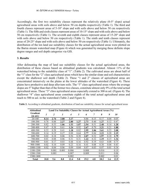
- Page 411: M. ÖZTÜRK et al./ ISEM2016 Alanya
- Page 415 and 416: M. ÖZTÜRK et al./ ISEM2016 Alanya
- Page 417 and 418: M. ÖZTÜRK et al./ ISEM2016 Alanya
- Page 419 and 420: E. Gökyer et al./ ISEM2016 Alanya
- Page 421 and 422: E. Gökyer et al./ ISEM2016 Alanya
- Page 423 and 424: E. Gökyer et al./ ISEM2016 Alanya
- Page 425 and 426: E. Gökyer et al./ ISEM2016 Alanya
- Page 427 and 428: E. Gökyer et al./ ISEM2016 Alanya
- Page 429 and 430: O.H.Dede/ ISEM2016 Alanya - Turkey
- Page 431 and 432: O.H.Dede/ ISEM2016 Alanya - Turkey
- Page 433 and 434: O.H.Dede/ ISEM2016 Alanya - Turkey
- Page 435 and 436: O.H.Dede/ ISEM2016 Alanya - Turkey
- Page 437 and 438: ISEM2016, 3 rd International Sympos
- Page 439 and 440: E. ÇELEBİ / ISEM2016 Alanya - Tur
- Page 441 and 442: E. ÇELEBİ / ISEM2016 Alanya - Tur
- Page 443 and 444: E. ÇELEBİ / ISEM2016 Alanya - Tur
- Page 445 and 446: E. ÇELEBİ / ISEM2016 Alanya - Tur
- Page 447 and 448: ISEM2016, 3 rd International Sympos
- Page 449 and 450: Ö.H.Dede, H. Özer, S. Özdemir /
- Page 451 and 452: Ö.H.Dede, H. Özer, S. Özdemir /
- Page 453 and 454: ISEM2016, 3 rd International Sympos
- Page 455 and 456: İ.GÜMÜŞ / ISEM2016 Alanya - Tur
- Page 457 and 458: İ.GÜMÜŞ / ISEM2016 Alanya - Tur
- Page 459 and 460: İ.GÜMÜŞ / ISEM2016 Alanya - Tur
- Page 461 and 462: İ.GÜMÜŞ / ISEM2016 Alanya - Tur
- Page 463 and 464:
İ.GÜMÜŞ / ISEM2016 Alanya - Tur
- Page 465 and 466:
ISEM2016, 3 rd International Sympos
- Page 467 and 468:
M. ONAL / ISEM2016 Alanya - Turkey
- Page 469 and 470:
M. ONAL / ISEM2016 Alanya - Turkey
- Page 471 and 472:
M. ONAL / ISEM2016 Alanya - Turkey
- Page 473 and 474:
M. ONAL / ISEM2016 Alanya - Turkey
- Page 475 and 476:
M. ONAL / ISEM2016 Alanya - Turkey
- Page 477 and 478:
M. ONAL / ISEM2016 Alanya - Turkey
- Page 479 and 480:
S. GÜNDOĞDU FİDAN et al./ ISEM20
- Page 481 and 482:
S. GÜNDOĞDU FİDAN et al./ ISEM20
- Page 483 and 484:
S. GÜNDOĞDU FİDAN et al./ ISEM20
- Page 485 and 486:
S. GÜNDOĞDU FİDAN et al./ ISEM20
- Page 487 and 488:
S. GÜNDOĞDU FİDAN et al./ ISEM20
- Page 489 and 490:
ISEM2016, 3 rd International Sympos
- Page 491 and 492:
C. ORGEV et al./ ISEM2016 Alanya -
- Page 493 and 494:
C. ORGEV et al./ ISEM2016 Alanya -
- Page 495 and 496:
C. ORGEV et al./ ISEM2016 Alanya -
- Page 497 and 498:
C. ORGEV et al./ ISEM2016 Alanya -
- Page 499 and 500:
D. KARAYEL ve ark./ISEM2016 Alanya
- Page 501 and 502:
D. KARAYEL ve ark./ISEM2016 Alanya
- Page 503 and 504:
D. KARAYEL ve ark./ISEM2016 Alanya
- Page 505 and 506:
D. KARAYEL ve ark./ISEM2016 Alanya
- Page 507 and 508:
K. ALTUNTAS et al./ ISEM2016 Alanya
- Page 509 and 510:
K. ALTUNTAS et al./ ISEM2016 Alanya
- Page 511 and 512:
K. ALTUNTAS et al./ ISEM2016 Alanya
- Page 513 and 514:
K. ALTUNTAS et al./ ISEM2016 Alanya
- Page 515 and 516:
E. ÖZTEMEL et al./ ISEM2016 Alanya
- Page 517 and 518:
E. ÖZTEMEL et al./ ISEM2016 Alanya
- Page 519 and 520:
E. ÖZTEMEL et al./ ISEM2016 Alanya
- Page 521 and 522:
H. ERCAN TEKSEN ve diğ./ ISEM2016
- Page 523 and 524:
H. ERCAN TEKSEN ve diğ./ ISEM2016
- Page 525 and 526:
H. ERCAN TEKSEN ve diğ./ ISEM2016
- Page 527 and 528:
H. ERCAN TEKSEN ve diğ./ ISEM2016
- Page 529 and 530:
Y. SARI et al./ ISEM2016 Alanya-Tur
- Page 531 and 532:
Y. SARI et al./ ISEM2016 Alanya-Tur
- Page 533 and 534:
Y. SARI et al./ ISEM2016 Alanya-Tur
- Page 535 and 536:
Y. SARI et al./ ISEM2016 Alanya-Tur
- Page 537 and 538:
ISEM2016, 3 rd International Sympos
- Page 539 and 540:
E. KANDEMIR et al./ ISEM2016 Alanya
- Page 541 and 542:
E. KANDEMIR et al./ ISEM2016 Alanya
- Page 543 and 544:
E. KANDEMIR et al./ ISEM2016 Alanya
- Page 545 and 546:
E. KANDEMIR et al./ ISEM2016 Alanya
- Page 547 and 548:
ISEM2016, 3 rd International Sympos
- Page 549 and 550:
Z. HOSSEINI AND A. GHALEHJOUGHI / I
- Page 551 and 552:
Z. HOSSEINI AND A. GHALEHJOUGHI / I
- Page 553 and 554:
Z. HOSSEINI AND A. GHALEHJOUGHI / I
- Page 555 and 556:
Z. HOSSEINI AND A. GHALEHJOUGHI / I
- Page 557 and 558:
Z. HOSSEINI AND A. GHALEHJOUGHI / I
- Page 559 and 560:
Z. HOSSEINI AND A. GHALEHJOUGHI / I
- Page 561 and 562:
ISEM2016, 3 rd International Sympos
- Page 563 and 564:
A. DEVECI et al./ ISEM2016, Alanya
- Page 565 and 566:
A. DEVECI et al./ ISEM2016, Alanya
- Page 567 and 568:
A. DEVECI et al./ ISEM2016, Alanya
- Page 569 and 570:
A. DEVECI et al./ ISEM2016, Alanya
- Page 571 and 572:
M. Celebi et al./ ISEM2016 Alanya -
- Page 573 and 574:
M. Celebi et al./ ISEM2016 Alanya -
- Page 575 and 576:
M. Celebi et al./ ISEM2016 Alanya -
- Page 577 and 578:
M. Celebi et al./ ISEM2016 Alanya -
- Page 579 and 580:
K. KARABACAK et al./ ISEM2016 Alany
- Page 581 and 582:
K. KARABACAK et al./ ISEM2016 Alany
- Page 583 and 584:
K. KARABACAK et al./ ISEM2016 Alany
- Page 585 and 586:
K. KARABACAK et al./ ISEM2016 Alany
- Page 587 and 588:
K. KARABACAK et al./ ISEM2016 Alany
- Page 589 and 590:
N. TASLACI et al./ ISEM2016 Alanya
- Page 591 and 592:
N. TASLACI et al./ ISEM2016 Alanya
- Page 593 and 594:
N. TASLACI et al./ ISEM2016 Alanya
- Page 595 and 596:
N. TASLACI et al./ ISEM2016 Alanya
- Page 597 and 598:
N. TASLACI et al./ ISEM2016 Alanya
- Page 599 and 600:
ISEM2016, 3 rd International Sympos
- Page 601 and 602:
M. MWANZA et al./ ISEM2016 Alanya -
- Page 603 and 604:
M. MWANZA et al./ ISEM2016 Alanya -
- Page 605 and 606:
M. MWANZA et al./ ISEM2016 Alanya -
- Page 607 and 608:
M. MWANZA et al./ ISEM2016 Alanya -
- Page 609 and 610:
M. MWANZA et al./ ISEM2016 Alanya -
- Page 611 and 612:
K.S. GUMUS / ISEM2016 Alanya - Turk
- Page 613 and 614:
K.S. GUMUS / ISEM2016 Alanya - Turk
- Page 615 and 616:
K.S. GUMUS / ISEM2016 Alanya - Turk
- Page 617 and 618:
K.S. GUMUS / ISEM2016 Alanya - Turk
- Page 619 and 620:
K.S. GUMUS / ISEM2016 Alanya - Turk
- Page 621 and 622:
K.S. GUMUS / ISEM2016 Alanya - Turk
- Page 623 and 624:
K.S. GUMUS / ISEM2016 Alanya - Turk
- Page 625 and 626:
K.S. GUMUS / ISEM2016 Alanya - Turk
- Page 627 and 628:
ISEM2016, 3 rd International Sympos
- Page 629 and 630:
M. MWANZA et al./ ISEM2016 Alanya -
- Page 631 and 632:
M. MWANZA et al./ ISEM2016 Alanya -
- Page 633 and 634:
M. MWANZA et al./ ISEM2016 Alanya -
- Page 635 and 636:
M. MWANZA et al./ ISEM2016 Alanya -
- Page 637 and 638:
M. MWANZA et al./ ISEM2016 Alanya -
- Page 639 and 640:
M. MWANZA et al./ ISEM2016 Alanya -
- Page 641 and 642:
A. CONKER./ ISEM2016 Alanya - Turke
- Page 643 and 644:
A. CONKER./ ISEM2016 Alanya - Turke
- Page 645 and 646:
A. CONKER./ ISEM2016 Alanya - Turke
- Page 647 and 648:
A. CONKER./ ISEM2016 Alanya - Turke
- Page 649 and 650:
A. CONKER./ ISEM2016 Alanya - Turke
- Page 651 and 652:
B.EREN et al./ ISEM2016 Alanya - Tu
- Page 653 and 654:
B.EREN et al./ ISEM2016 Alanya - Tu
- Page 655 and 656:
B.EREN et al./ ISEM2016 Alanya - Tu
- Page 657 and 658:
B.EREN et al./ ISEM2016 Alanya - Tu
- Page 659 and 660:
B.EREN et al./ ISEM2016 Alanya - Tu
- Page 661 and 662:
C. DEDE et al./ ISEM2016 - Alanya -
- Page 663 and 664:
C. DEDE et al./ ISEM2016 - Alanya -
- Page 665 and 666:
C. DEDE et al./ ISEM2016 - Alanya -
- Page 667 and 668:
C. DEDE et al./ ISEM2016 - Alanya -
- Page 669 and 670:
ISEM2016, 3 rd International Sympos
- Page 671 and 672:
K. YAMAN VE C. YAKA / ISEM2016 - Al
- Page 673 and 674:
K. YAMAN VE C. YAKA / ISEM2016 - Al
- Page 675 and 676:
K. YAMAN VE C. YAKA / ISEM2016 - Al
- Page 677 and 678:
ISEM2016, 3 rd International Sympos
- Page 679 and 680:
S.B. TOSUN/ ISEM2016 Alanya - Turke
- Page 681 and 682:
S.B. TOSUN/ ISEM2016 Alanya - Turke
- Page 683 and 684:
S.B. TOSUN/ ISEM2016 Alanya - Turke
- Page 685 and 686:
S.B. TOSUN/ ISEM2016 Alanya - Turke
- Page 687 and 688:
ISEM2016, 3 rd International Sympos
- Page 689 and 690:
A. ALP et al./ ISEM2016 Alanya - Tu
- Page 691 and 692:
A. ALP et al./ ISEM2016 Alanya - Tu
- Page 693 and 694:
A. ALP et al./ ISEM2016 Alanya - Tu
- Page 695 and 696:
A. ALP et al./ ISEM2016 Alanya - Tu
- Page 697 and 698:
E. DEBİK, H.İ.UZUN/ ISEM2016 Alan
- Page 699 and 700:
E. DEBİK, H.İ.UZUN/ ISEM2016 Alan
- Page 701 and 702:
E. DEBİK, H.İ.UZUN/ ISEM2016 Alan
- Page 703 and 704:
E. DEBİK, H.İ.UZUN/ ISEM2016 Alan
- Page 705 and 706:
K.CENGİZ et al./ ISEM2016 Alanya -
- Page 707 and 708:
K.CENGİZ et al./ ISEM2016 Alanya -
- Page 709 and 710:
K.CENGİZ et al./ ISEM2016 Alanya -
- Page 711 and 712:
K.CENGİZ et al./ ISEM2016 Alanya -
- Page 713 and 714:
K.CENGİZ et al./ ISEM2016 Alanya -
- Page 715 and 716:
N. GOKALP./ ISEM2016 Alanya - Turke
- Page 717 and 718:
N. GOKALP./ ISEM2016 Alanya - Turke
- Page 719 and 720:
N. GOKALP./ ISEM2016 Alanya - Turke
- Page 721 and 722:
İ. TEĞİN ve S. AKDENİZ./ ISEM20
- Page 723 and 724:
İ. TEĞİN ve S. AKDENİZ./ ISEM20
- Page 725 and 726:
İ. TEĞİN ve S. AKDENİZ./ ISEM20
- Page 727 and 728:
İ. TEĞİN ve S. AKDENİZ./ ISEM20
- Page 729 and 730:
İ. TEĞİN ve S. AKDENİZ./ ISEM20
- Page 731 and 732:
İ. TEĞİN ve S. AKDENİZ./ ISEM20
- Page 733 and 734:
ISEM2016, 3 rd International Sympos
- Page 735 and 736:
M. A. Yurdusev/ ISEM2016 Alanya- Tu
- Page 737 and 738:
ISEM2016, 3 rd International Sympos
- Page 739 and 740:
Ö.A. ATASOY/ ISEM2016 Alanya - Tur
- Page 741 and 742:
Ö.A. ATASOY/ ISEM2016 Alanya - Tur
- Page 743 and 744:
Ö.A. ATASOY/ ISEM2016 Alanya - Tur
- Page 745 and 746:
Ö.A. ATASOY/ ISEM2016 Alanya - Tur
- Page 747 and 748:
Ö.A. ATASOY/ ISEM2016 Alanya - Tur
- Page 749 and 750:
To obtain more yield per unit area,
- Page 751 and 752:
It was determined that excess accum
- Page 753 and 754:
inorganic fertilization but the man
- Page 755 and 756:
[4] Öner, N., 1998. Asit Bir Topra
- Page 757 and 758:
ISEM2016, 3 rd International Sympos
- Page 759 and 760:
M. KARA AND T. SERMENLİ/ ISEM2016
- Page 761 and 762:
M. KARA AND T. SERMENLİ/ ISEM2016
- Page 763 and 764:
M. KARA AND T. SERMENLİ/ ISEM2016
- Page 765 and 766:
İ. ZORLUER et al./ ISEM2016 Alanya
- Page 767 and 768:
İ. ZORLUER et al./ ISEM2016 Alanya
- Page 769 and 770:
İ. ZORLUER et al./ ISEM2016 Alanya
- Page 771 and 772:
ISEM2016, 3 rd International Sympos
- Page 773 and 774:
SL. KUZU et al./ ISEM2016 Alanya -
- Page 775 and 776:
SL. KUZU et al./ ISEM2016 Alanya -
- Page 777 and 778:
SL. KUZU et al./ ISEM2016 Alanya -
- Page 779 and 780:
ISEM2016, 3 rd International Sympos
- Page 781 and 782:
S. YÜKSEK et al./ ISEM2016 Alanya
- Page 783 and 784:
S. YÜKSEK et al./ ISEM2016 Alanya
- Page 785 and 786:
S. YÜKSEK et al./ ISEM2016 Alanya
- Page 787 and 788:
S. YÜKSEK et al./ ISEM2016 Alanya
- Page 789 and 790:
S. YÜKSEK et al./ ISEM2016 Alanya
- Page 791 and 792:
S. YÜKSEK et al./ ISEM2016 Alanya
- Page 793 and 794:
ISEM2016, 3 rd International Sympos
- Page 795 and 796:
M. ARIZA et al./ ISEM2016 Alanya -
- Page 797 and 798:
M. ARIZA et al./ ISEM2016 Alanya -
- Page 799 and 800:
M. ARIZA et al./ ISEM2016 Alanya -
- Page 801 and 802:
M. ARIZA et al./ ISEM2016 Alanya -
- Page 803 and 804:
M. ARIZA et al./ ISEM2016 Alanya -
- Page 805 and 806:
ISEM2016, 3 rd International Sympos
- Page 807 and 808:
K. ÖZAN et al./ ISEM2016 Alanya -
- Page 809 and 810:
K. ÖZAN et al./ ISEM2016 Alanya -
- Page 811 and 812:
ISEM2016, 3 rd International Sympos
- Page 813 and 814:
R.O. BAWAZIR et al./ ISEM2016 Alany
- Page 815 and 816:
R.O. BAWAZIR et al./ ISEM2016 Alany
- Page 817 and 818:
R.O. BAWAZIR et al./ ISEM2016 Alany
- Page 819 and 820:
R.O. BAWAZIR et al./ ISEM2016 Alany
- Page 821 and 822:
J. CHAKCHAK et al./ ISEM2016 Alanya
- Page 823 and 824:
J. CHAKCHAK et al./ ISEM2016 Alanya
- Page 825 and 826:
J. CHAKCHAK et al./ ISEM2016 Alanya
- Page 827 and 828:
J. CHAKCHAK et al./ ISEM2016 Alanya
- Page 829 and 830:
J. CHAKCHAK et al./ ISEM2016 Alanya
- Page 831 and 832:
J. CHAKCHAK et al./ ISEM2016 Alanya
- Page 833 and 834:
J. CHAKCHAK et al./ ISEM2016 Alanya
- Page 835 and 836:
Ç. GÜLMEZ/ ISEM2016 Alanya - Turk
- Page 837 and 838:
Ç. GÜLMEZ/ ISEM2016 Alanya - Turk
- Page 839 and 840:
Ç. GÜLMEZ/ ISEM2016 Alanya - Turk
- Page 841 and 842:
Ç. GÜLMEZ/ ISEM2016 Alanya - Turk
- Page 843 and 844:
Ç. GÜLMEZ/ ISEM2016 Alanya - Turk
- Page 845 and 846:
Ç. GÜLMEZ/ ISEM2016 Alanya - Turk
- Page 847 and 848:
Ç. GÜLMEZ/ ISEM2016 Alanya - Turk
- Page 849 and 850:
ISEM2016, 3 rd International Sympos
- Page 851 and 852:
A. C. CAKMAK et al./ ISEM2016 Alany
- Page 853 and 854:
A. C. CAKMAK et al./ ISEM2016 Alany
- Page 855 and 856:
A. C. CAKMAK et al./ ISEM2016 Alany
- Page 857 and 858:
A. C. CAKMAK et al./ ISEM2016 Alany
- Page 859 and 860:
ISEM2016, 3 rd International Sympos
- Page 861 and 862:
N. SOZBIR et al./ ISEM2016 Alanya -
- Page 863 and 864:
N. SOZBIR et al./ ISEM2016 Alanya -
- Page 865 and 866:
N. SOZBIR et al./ ISEM2016 Alanya -
- Page 867 and 868:
F.AYĞAN/ ISEM2016 Alanya - Turkey
- Page 869 and 870:
F.AYĞAN/ ISEM2016 Alanya - Turkey
- Page 871 and 872:
F.AYĞAN/ ISEM2016 Alanya - Turkey
- Page 873 and 874:
F.AYĞAN/ ISEM2016 Alanya - Turkey
- Page 875 and 876:
ISEM2016, 3 rd International Sympos
- Page 877 and 878:
A. ATES et al./ ISEM2016 Alanya - T
- Page 879 and 880:
A. ATES et al./ ISEM2016 Alanya - T
- Page 881 and 882:
A. ATES et al./ ISEM2016 Alanya - T
- Page 883 and 884:
A. ATES et al./ ISEM2016 Alanya - T
- Page 885 and 886:
ISEM2016, 3 rd International Sympos
- Page 887 and 888:
A.A.HAFAZALLA et al./ ISEM2016 Alan
- Page 889 and 890:
A.A.HAFAZALLA et al./ ISEM2016 Alan
- Page 891 and 892:
A.A.HAFAZALLA et al./ ISEM2016 Alan
- Page 893 and 894:
A.A.HAFAZALLA et al./ ISEM2016 Alan
- Page 895 and 896:
A.A.HAFAZALLA et al./ ISEM2016 Alan
- Page 897 and 898:
S. BIÇAK ve R. ARAS/ ISEM2016 Alan
- Page 899 and 900:
S. BIÇAK ve R. ARAS/ ISEM2016 Alan
- Page 901 and 902:
S. BIÇAK ve R. ARAS/ ISEM2016 Alan
- Page 903 and 904:
S. BIÇAK ve R. ARAS/ ISEM2016 Alan
- Page 905 and 906:
S. BIÇAK ve R. ARAS/ ISEM2016 Alan
- Page 907 and 908:
S. BIÇAK ve R. ARAS/ ISEM2016 Alan
- Page 909 and 910:
R. KOCAMAN et al./ ISEM2016 Alanya
- Page 911 and 912:
R. KOCAMAN et al./ ISEM2016 Alanya
- Page 913 and 914:
R. KOCAMAN et al./ ISEM2016 Alanya
- Page 915 and 916:
R. KOCAMAN et al./ ISEM2016 Alanya
- Page 917 and 918:
R. KOCAMAN et al./ ISEM2016 Alanya
- Page 919 and 920:
Edited with the trial version of Fo
- Page 921 and 922:
Edited with the trial version of Fo
- Page 923 and 924:
Edited with the trial version of Fo
- Page 925 and 926:
Edited with the trial version of Fo
- Page 927 and 928:
Edited with the trial version of Fo
- Page 929 and 930:
Edited with the trial version of Fo
- Page 931 and 932:
Edited with the trial version of Fo
- Page 933 and 934:
Edited with the trial version of Fo
- Page 935 and 936:
Edited with the trial version of Fo
- Page 937 and 938:
Edited with the trial version of Fo
- Page 939 and 940:
Edited with the trial version of Fo
- Page 941 and 942:
Edited with the trial version of Fo
- Page 943 and 944:
Edited with the trial version of Fo
- Page 945 and 946:
Edited with the trial version of Fo
- Page 947 and 948:
M. CETIN / ISEM2016 Alanya - Turkey
- Page 949 and 950:
M. CETIN / ISEM2016 Alanya - Turkey
- Page 951 and 952:
M. CETIN / ISEM2016 Alanya - Turkey
- Page 953 and 954:
M. CETIN / ISEM2016 Alanya - Turkey
- Page 955 and 956:
M. CETIN / ISEM2016 Alanya - Turkey
- Page 957 and 958:
M. CETIN / ISEM2016 Alanya - Turkey
- Page 959 and 960:
M. CETIN / ISEM2016 Alanya - Turkey
- Page 961 and 962:
ISEM2016, 3 rd International Sympos
- Page 963 and 964:
H. NADAROGLU et al./ ISEM2016 Alany
- Page 965 and 966:
H. NADAROGLU et al./ ISEM2016 Alany
- Page 967 and 968:
A.Günindi Ersöz/ ISEM2016 Alanya
- Page 969 and 970:
A.Günindi Ersöz/ ISEM2016 Alanya
- Page 971 and 972:
A.Günindi Ersöz/ ISEM2016 Alanya
- Page 973 and 974:
A.Günindi Ersöz/ ISEM2016 Alanya
- Page 975 and 976:
M. ERAT et al./ ISEM2016 Alanya - T
- Page 977 and 978:
M. ERAT et al./ ISEM2016 Alanya - T
- Page 979 and 980:
M. ERAT et al./ ISEM2016 Alanya - T
- Page 981 and 982:
N. ERSEN and İ. AKYÜZ/ ISEM2016 A
- Page 983 and 984:
N. ERSEN and İ. AKYÜZ/ ISEM2016 A
- Page 985 and 986:
N. ERSEN and İ. AKYÜZ/ ISEM2016 A
- Page 987 and 988:
N. ERSEN and İ. AKYÜZ/ ISEM2016 A
- Page 989 and 990:
N. ERSEN and İ. AKYÜZ/ ISEM2016 A
- Page 991 and 992:
M. ÖZTÜRK./ ISEM2016 Alanya - Tur
- Page 993 and 994:
M. ÖZTÜRK./ ISEM2016 Alanya - Tur
- Page 995 and 996:
M. ÖZTÜRK./ ISEM2016 Alanya - Tur
- Page 997 and 998:
M. ÖZTÜRK./ ISEM2016 Alanya - Tur
- Page 999 and 1000:
M. ÖZTÜRK./ ISEM2016 Alanya - Tur
- Page 1001 and 1002:
M. ÖZTÜRK./ ISEM2016 Alanya - Tur
- Page 1003 and 1004:
M. ÖZTÜRK./ ISEM2016 Alanya - Tur
- Page 1005 and 1006:
ISEM2016, 3 rd International Sympos
- Page 1007 and 1008:
Y. EŞİT./ ISEM2016 Alanya - Turke
- Page 1009 and 1010:
Y. EŞİT./ ISEM2016 Alanya - Turke
- Page 1011 and 1012:
Y. EŞİT./ ISEM2016 Alanya - Turke
- Page 1013 and 1014:
Y. EŞİT./ ISEM2016 Alanya - Turke
- Page 1015 and 1016:
Y. EŞİT./ ISEM2016 Alanya - Turke
- Page 1017 and 1018:
R.ASLAN / ISEM2016 Alanya - Turkey
- Page 1019 and 1020:
R.ASLAN / ISEM2016 Alanya - Turkey
- Page 1021 and 1022:
R.ASLAN / ISEM2016 Alanya - Turkey
- Page 1023 and 1024:
R.ASLAN / ISEM2016 Alanya - Turkey
- Page 1025 and 1026:
R.ASLAN / ISEM2016 Alanya - Turkey
- Page 1027 and 1028:
E.TAŞĞIN et al./ ISEM2016 Alanya
- Page 1029 and 1030:
E.TAŞĞIN et al./ ISEM2016 Alanya
- Page 1031 and 1032:
E.TAŞĞIN et al./ ISEM2016 Alanya
- Page 1033 and 1034:
B.TOPAL./ ISEM2016 Alanya - Turkey
- Page 1035 and 1036:
B.TOPAL./ ISEM2016 Alanya - Turkey
- Page 1037 and 1038:
B.TOPAL./ ISEM2016 Alanya - Turkey
- Page 1039 and 1040:
B.TOPAL./ ISEM2016 Alanya - Turkey
- Page 1041 and 1042:
B.TOPAL./ ISEM2016 Alanya - Turkey
- Page 1043 and 1044:
Ö.Uygun et al./ ISEM2016 Alanya -
- Page 1045 and 1046:
Ö.Uygun et al./ ISEM2016 Alanya -
- Page 1047 and 1048:
Ö.Uygun et al./ ISEM2016 Alanya -
- Page 1049 and 1050:
Ö.Uygun et al./ ISEM2016 Alanya -
- Page 1051 and 1052:
Ö.Uygun et al./ ISEM2016 Alanya -
- Page 1053 and 1054:
ISEM2016, 3 rd International Sympos
- Page 1055 and 1056:
E.AYDOGMUS et al./ ISEM2016 Alanya
- Page 1057 and 1058:
E.AYDOGMUS et al./ ISEM2016 Alanya
- Page 1059 and 1060:
E.AYDOGMUS et al./ ISEM2016 Alanya
- Page 1061 and 1062:
E.AYDOGMUS et al./ ISEM2016 Alanya
- Page 1063 and 1064:
Ö. KARABIYIK / ISEM2016 Alanya - T
- Page 1065 and 1066:
Ö. KARABIYIK / ISEM2016 Alanya - T
- Page 1067 and 1068:
Ö. KARABIYIK / ISEM2016 Alanya - T
- Page 1069 and 1070:
ISEM2016, 3 rd International Sympos
- Page 1071 and 1072:
A.A. KARADAĞ et al./ ISEM2016 Alan
- Page 1073 and 1074:
A.A. KARADAĞ et al./ ISEM2016 Alan
- Page 1075 and 1076:
A.A. KARADAĞ et al./ ISEM2016 Alan
- Page 1077 and 1078:
A.A. KARADAĞ et al./ ISEM2016 Alan
- Page 1079 and 1080:
ISEM2016, 3 rd International Sympos
- Page 1081 and 1082:
G. AÇIKBAŞ et al./ ISEM2016 Alany
- Page 1083 and 1084:
G. AÇIKBAŞ et al./ ISEM2016 Alany
- Page 1085 and 1086:
G. AÇIKBAŞ et al./ ISEM2016 Alany
- Page 1087 and 1088:
G. AÇIKBAŞ et al./ ISEM2016 Alany
- Page 1089 and 1090:
ISEM2016, 3 rd International Sympos
- Page 1091 and 1092:
N. CALIS ACIKBAS et al./ ISEM2016 A
- Page 1093 and 1094:
N. CALIS ACIKBAS et al./ ISEM2016 A
- Page 1095 and 1096:
N. CALIS ACIKBAS et al./ ISEM2016 A
- Page 1097 and 1098:
N. CALIS ACIKBAS et al./ ISEM2016 A
- Page 1099 and 1100:
ISEM2016, 3 rd International Sympos
- Page 1101 and 1102:
K. ÖZDEMİR / ISEM2016 Alanya - Tu
- Page 1103 and 1104:
K. ÖZDEMİR / ISEM2016 Alanya - Tu
- Page 1105 and 1106:
K. ÖZDEMİR / ISEM2016 Alanya - Tu
- Page 1107 and 1108:
M. SAYGILI VE DİĞ./ ISEM2016 Alan
- Page 1109 and 1110:
M. SAYGILI VE DİĞ./ ISEM2016 Alan
- Page 1111 and 1112:
M. SAYGILI VE DİĞ./ ISEM2016 Alan
- Page 1113 and 1114:
M. SAYGILI VE DİĞ./ ISEM2016 Alan
- Page 1115 and 1116:
M. SAYGILI VE DİĞ./ ISEM2016 Alan
- Page 1117 and 1118:
BOWA.K. C et al./ ISEM2016 Alanya -
- Page 1119 and 1120:
BOWA.K. C et al./ ISEM2016 Alanya -
- Page 1121 and 1122:
BOWA.K. C et al./ ISEM2016 Alanya -
- Page 1123 and 1124:
BOWA.K. C et al./ ISEM2016 Alanya -
- Page 1125 and 1126:
BOWA.K. C et al./ ISEM2016 Alanya -
- Page 1127 and 1128:
F. BAYRAKCI KAREL et al./ ISEM2016
- Page 1129 and 1130:
F. BAYRAKCI KAREL et al./ ISEM2016
- Page 1131 and 1132:
F. BAYRAKCI KAREL et al./ ISEM2016
- Page 1133 and 1134:
ISEM2016, 3 rd International Sympos
- Page 1135 and 1136:
H.N.SEZER et al./ ISEM2016 Alanya -
- Page 1137 and 1138:
H.N.SEZER et al./ ISEM2016 Alanya -
- Page 1139 and 1140:
H.N.SEZER et al./ ISEM2016 Alanya -
- Page 1141 and 1142:
H.N.SEZER et al./ ISEM2016 Alanya -
- Page 1143 and 1144:
H.N.SEZER et al./ ISEM2016 Alanya -
- Page 1145 and 1146:
ISEM2016, 3 rd International Sympos
- Page 1147 and 1148:
A.S.ERSES YAY et al./ ISEM2016 Alan
- Page 1149 and 1150:
A.S.ERSES YAY et al./ ISEM2016 Alan
- Page 1151 and 1152:
A.S.ERSES YAY et al./ ISEM2016 Alan
- Page 1153 and 1154:
A.S.ERSES YAY et al./ ISEM2016 Alan
- Page 1155 and 1156:
S. C. YENER et al./ ISEM2016 Alanya
- Page 1157 and 1158:
S. C. YENER et al./ ISEM2016 Alanya
- Page 1159 and 1160:
S. C. YENER et al./ ISEM2016 Alanya
- Page 1161 and 1162:
S. C. YENER et al./ ISEM2016 Alanya
- Page 1163 and 1164:
S. C. YENER et al./ ISEM2016 Alanya
- Page 1165 and 1166:
ISEM2016, 3 rd International Sympos
- Page 1167 and 1168:
P. TOPTAŞ and A.S.E YAY/ ISEM2016
- Page 1169 and 1170:
P. TOPTAŞ and A.S.E YAY/ ISEM2016
- Page 1171 and 1172:
P. TOPTAŞ and A.S.E YAY/ ISEM2016
- Page 1173 and 1174:
P. TOPTAŞ and A.S.E YAY/ ISEM2016
- Page 1175 and 1176:
A.CANATAN et al./ ISEM2016 Alanya -
- Page 1177 and 1178:
A.CANATAN et al./ ISEM2016 Alanya -
- Page 1179 and 1180:
ISEM2016, 3 rd International Sympos
- Page 1181 and 1182:
F. YARDIMCIOĞLU ve F.SAVAŞAN / IS
- Page 1183 and 1184:
F. YARDIMCIOĞLU ve F.SAVAŞAN / IS
- Page 1185 and 1186:
F. YARDIMCIOĞLU ve F.SAVAŞAN / IS
- Page 1187 and 1188:
F. YARDIMCIOĞLU ve F.SAVAŞAN / IS
- Page 1189 and 1190:
F. YARDIMCIOĞLU ve F.SAVAŞAN / IS
- Page 1191 and 1192:
F. YARDIMCIOĞLU ve F.SAVAŞAN / IS
- Page 1193 and 1194:
F. YILMAZ/ ISEM2016 Alanya - Turkey
- Page 1195 and 1196:
F. YILMAZ/ ISEM2016 Alanya - Turkey
- Page 1197 and 1198:
F. YILMAZ/ ISEM2016 Alanya - Turkey
- Page 1199 and 1200:
ISEM2016, 3 rd International Sympos
- Page 1201 and 1202:
Z. OSMANOVIĆ et al./ ISEM2016 Alan
- Page 1203 and 1204:
Z. OSMANOVIĆ et al./ ISEM2016 Alan
- Page 1205 and 1206:
Z. OSMANOVIĆ et al./ ISEM2016 Alan
- Page 1207 and 1208:
S. EFIL/ ISEM2016 Alanya - Turkey d
- Page 1209 and 1210:
S. EFIL/ ISEM2016 Alanya - Turkey v
- Page 1211 and 1212:
S. EFIL/ ISEM2016 Alanya - Turkey
- Page 1213 and 1214:
S. EFIL/ ISEM2016 Alanya - Turkey i
- Page 1215 and 1216:
S. EFIL/ ISEM2016 Alanya - Turkey c