

A Semi-Implicit, Three-Dimensional Model for Estuarine ... - USGS
A Semi-Implicit, Three-Dimensional Model for Estuarine ... - USGS
A Semi-Implicit, Three-Dimensional Model for Estuarine ... - USGS

You also want an ePaper? Increase the reach of your titles
YUMPU automatically turns print PDFs into web optimized ePapers that Google loves.
116 A <strong>Semi</strong>-<strong>Implicit</strong>, <strong>Three</strong>-<strong>Dimensional</strong> <strong>Model</strong> <strong>for</strong> <strong>Estuarine</strong> Circulation<br />
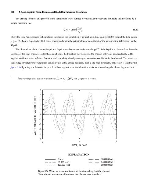
The driving <strong>for</strong>ce <strong>for</strong> this problem is the variation in water surface elevation ζ at the seaward boundary that is caused by a<br />
simple harmonic tide<br />
2πt<br />
ζ() t = Asin⎛-------<br />
⎞,<br />
(5.1)<br />
⎝ t ⎠<br />
p<br />
where the time t is expressed in hours from the start of the simulation. The tidal amplitude is A = 3 ft (0.9 m) and the tidal period<br />
is t p = 12.4 hours. A period of 12.4 hours corresponds with the principal lunar constituent of the astronomical tide known as the<br />
M 2 tide.<br />
The dimensions of the channel length and depth were chosen so that the wavelength 49 of the M 2 tide is close to four times the<br />
length L of the tidal channel. Under these conditions, the traveling wave entering the channel interferes constructively (adds<br />
together) with the wave reflected from the wall boundary, thereby setting up a resonant oscillation in the channel. The result is a<br />
tidal range of water surface elevation that is greater at the closed boundary than at the open boundary. This effect is illustrated in<br />
figure 5.14 by using a solution to the problem showing water surface elevation at six locations along the channel against time.<br />
49The wavelength of the tide can be estimated as Lw = tp ⋅ gH0 with tp expressed in seconds.<br />
WATER SURFACE ELEVATION, IN FEET<br />
5<br />
4<br />
3<br />
2<br />
1<br />
0<br />
−1<br />
−2<br />
−3<br />
−4<br />
−5<br />
0 1<br />
2<br />
TIME, IN DAYS<br />
EXPLANATION<br />
0 feet<br />
60,000 feet<br />
120,000 feet<br />
180,000 feet<br />
240,000 feet<br />
300,000 feet<br />
Figure 5.14. Water surface elevations at six locations along the tidal channel.<br />
The distances are measured landward from the seaward boundary.


