

A Semi-Implicit, Three-Dimensional Model for Estuarine ... - USGS
A Semi-Implicit, Three-Dimensional Model for Estuarine ... - USGS
A Semi-Implicit, Three-Dimensional Model for Estuarine ... - USGS

You also want an ePaper? Increase the reach of your titles
YUMPU automatically turns print PDFs into web optimized ePapers that Google loves.
2. Governing Equations and Boundary Conditions 53<br />
with a special flux-corrected-transport (Zalesak, 1979) algorithm to prevent the collapsing of coordinate layers, but their approach<br />
is still not tractable <strong>for</strong> application to most estuaries. In a few instances, multilayer models have been used with some success in<br />
studies of estuarine density fronts.<br />
The third type of coordinate system is based on a vertically “normalized” or “stretched” coordinate that is derived by trans-<br />
<strong>for</strong>ming the z-coordinate to create a constant depth flow domain. This coordinate system is called the σ-coordinate system; its use<br />
generally requires a constant number of grid boxes in the vertical at all horizontal grid points in a model, independent of the water<br />
depth. This type of trans<strong>for</strong>mation was first proposed by Phillips (1957) <strong>for</strong> use in numerical meteorological <strong>for</strong>ecasting and was<br />
later introduced <strong>for</strong> lake modeling by Freeman and others (1972) and Haq and others (1974). Several years later, applications to<br />
ocean modeling (Durance, 1976; Davies, 1980; Owen, 1980) and bay modeling (Sen Gupta and others, 1981) first appeared.<br />
Because the σ-coordinate system is so widely used in 3-D models of water bodies having variable topography, the details <strong>for</strong> the<br />
trans<strong>for</strong>mation of the governing equations are included in Appendix C.<br />
The chief advantage of the σ-coordinate system is that it maps the surface and bottom into horizontal coordinate surfaces. 23<br />
The σ numerical grid is not fixed in space but actually moves up and down with any oscillation of the free surface; in this way, it<br />
treats the dynamic free surface in a fairly straight<strong>for</strong>ward manner. Its use also eliminates the need to add layers of small vertical<br />
extent to correctly resolve the currents in shallow areas. It is particularly convenient, there<strong>for</strong>e, to use this system <strong>for</strong> coastal ocean<br />
modeling when it is desirable <strong>for</strong> the vertical grid spacing to be small in the shallow waters of the continental shelf and large in the<br />
deep waters of the ocean. It is possible to use coordinate stretching within the σ-coordinate system to vary the spacing of grid points<br />
to achieve higher resolution at some point in the water column such as near the free surface or bottom (Noye and Stevens, 1987;<br />
Huang and Spaulding, 1995). Some authors (Spall and Robinson, 1990; Gerdes, 1993) have developed models using hybrid coor-<br />
dinate systems between the σ-coordinate and z-coordinate systems, which attempt to draw upon the best features of each.<br />
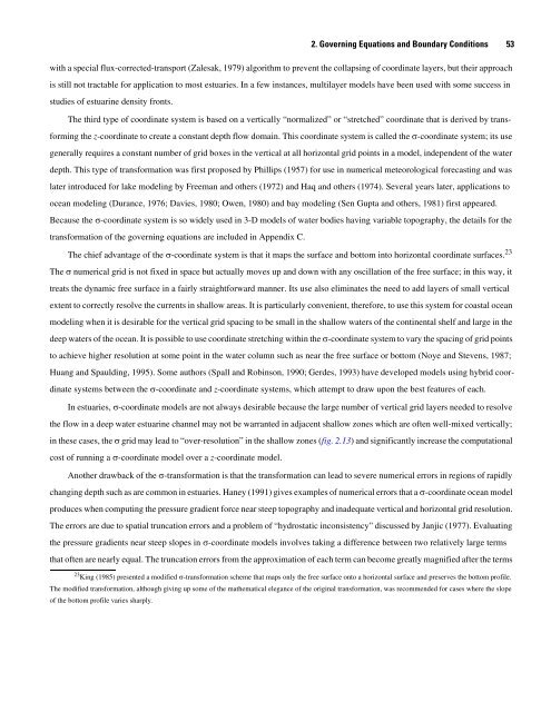
In estuaries, σ-coordinate models are not always desirable because the large number of vertical grid layers needed to resolve<br />
the flow in a deep water estuarine channel may not be warranted in adjacent shallow zones which are often well-mixed vertically;<br />
in these cases, the σ grid may lead to “over-resolution” in the shallow zones (fig. 2.13) and significantly increase the computational<br />
cost of running a σ-coordinate model over a z-coordinate model.<br />
Another drawback of the σ-trans<strong>for</strong>mation is that the trans<strong>for</strong>mation can lead to severe numerical errors in regions of rapidly<br />
changing depth such as are common in estuaries. Haney (1991) gives examples of numerical errors that a σ-coordinate ocean model<br />
produces when computing the pressure gradient <strong>for</strong>ce near steep topography and inadequate vertical and horizontal grid resolution.<br />
The errors are due to spatial truncation errors and a problem of “hydrostatic inconsistency” discussed by Janjic (1977). Evaluating<br />
the pressure gradients near steep slopes in σ-coordinate models involves taking a difference between two relatively large terms<br />
that often are nearly equal. The truncation errors from the approximation of each term can become greatly magnified after the terms<br />
23 King (1985) presented a modified σ-trans<strong>for</strong>mation scheme that maps only the free surface onto a horizontal surface and preserves the bottom profile.<br />
The modified trans<strong>for</strong>mation, although giving up some of the mathematical elegance of the original trans<strong>for</strong>mation, was recommended <strong>for</strong> cases where the slope<br />
of the bottom profile varies sharply.


