- Page 5 and 6:
SUPLEMENTO - GEHIGARRIA 31 Not only
- Page 9:
Not only Food. Marine, Terrestrial
- Page 12 and 13:
10 ESTEBAN ÁLVAREZ-FERNÁNDEZ, E.
- Page 14 and 15:
12 ESTEBAN ÁLVAREZ-FERNÁNDEZ, E.
- Page 17 and 18:
Not only Food. Marine, Terrestrial
- Page 20 and 21:
Radiocarbon dating of shell carbona
- Page 22 and 23:
20 KATERINA DOUKA, THOMAS F. G. HIG
- Page 24 and 25:
22 KATERINA DOUKA, THOMAS F. G. HIG
- Page 26 and 27:
24 KATERINA DOUKA, THOMAS F. G. HIG
- Page 28 and 29:
26 KATERINA DOUKA, THOMAS F. G. HIG
- Page 30 and 31:
Marine shell beads from the Gravett
- Page 32 and 33:
30 CRISTINA SAN JUAN-FOUCHER & PASC
- Page 34 and 35:
32 CRISTINA SAN JUAN-FOUCHER & PASC
- Page 36 and 37:
34 CRISTINA SAN JUAN-FOUCHER & PASC
- Page 38 and 39:
Upper Paleolithic ornament seashell
- Page 40 and 41:
38 ANTONIO J. RODRÍGUEZ-HIDALGO, A
- Page 42 and 43:
40 ANTONIO J. RODRÍGUEZ-HIDALGO, A
- Page 44 and 45:
42 ANTONIO J. RODRÍGUEZ-HIDALGO, A
- Page 46 and 47:
44 ANTONIO J. RODRÍGUEZ-HIDALGO, A
- Page 48:
46 ANTONIO J. RODRÍGUEZ-HIDALGO, A
- Page 51 and 52:
MUNIBE(Suplemento/Gehigarria) - nº
- Page 53 and 54:
The personal ornaments made from mo
- Page 55 and 56:
The personal ornaments made from mo
- Page 57 and 58:
The personal ornaments made from mo
- Page 60 and 61:
Magdalenian marine shells from El H
- Page 62 and 63:
60 MIGUEL ÁNGEL FANO & ESTEBAN ÁL
- Page 64 and 65:
62 MIGUEL ÁNGEL FANO & ESTEBAN ÁL
- Page 66 and 67:
64 MIGUEL ÁNGEL FANO & ESTEBAN ÁL
- Page 68 and 69:
66 MIGUEL ÁNGEL FANO & ESTEBAN ÁL
- Page 70:
68 MIGUEL ÁNGEL FANO & ESTEBAN ÁL
- Page 73 and 74:
MUNIBE(Suplemento/Gehigarria) - nº
- Page 75 and 76:
From the Mediterranean sea to the S
- Page 77 and 78:
From the Mediterranean sea to the S
- Page 79 and 80:
From the Mediterranean sea to the S
- Page 81 and 82:
MUNIBE(Suplemento/Gehigarria) - nº
- Page 83 and 84:
Archaeomalacological remains from t
- Page 85 and 86:
Archaeomalacological remains from t
- Page 87 and 88:
Archaeomalacological remains from t
- Page 89 and 90:
Archaeomalacological remains from t
- Page 91 and 92:
MUNIBE(Suplemento/Gehigarria) - nº
- Page 93 and 94:
Shell beads in the Pre-Pottery Neol
- Page 95 and 96:
Shell beads in the Pre-Pottery Neol
- Page 97 and 98:
Shell beads in the Pre-Pottery Neol
- Page 99 and 100:
Shell beads in the Pre-Pottery Neol
- Page 102 and 103:
Lost in the mountains? Marine ornam
- Page 104 and 105:
102 JORGE MARTÍNEZ-MORENO, RAFAEL
- Page 106 and 107:
104 JORGE MARTÍNEZ-MORENO, RAFAEL
- Page 108 and 109:
106 JORGE MARTÍNEZ-MORENO, RAFAEL
- Page 110 and 111:
108 JORGE MARTÍNEZ-MORENO, RAFAEL
- Page 112 and 113:
New data on Asturian shell midden s
- Page 114 and 115:
112 F. IGOR GUTIÉRREZ & MANUEL GON
- Page 116 and 117:
114 F. IGOR GUTIÉRREZ & MANUEL GON
- Page 118 and 119:
116 F. IGOR GUTIÉRREZ & MANUEL GON
- Page 120:
118 F. IGOR GUTIÉRREZ & MANUEL GON
- Page 123 and 124:
MUNIBE(Suplemento/Gehigarria) - nº
- Page 125 and 126:
Analysis of malacofauna remains fro
- Page 127 and 128:
Analysis of malacofauna remains fro
- Page 129 and 130:
Analysis of malacofauna remains fro
- Page 131 and 132:
MUNIBE(Suplemento/Gehigarria) - nº
- Page 133 and 134:
Shell as a raw material for tools a
- Page 135 and 136:
Shell as a raw material for tools a
- Page 137 and 138:
Shell as a raw material for tools a
- Page 139 and 140:
Shell as a raw material for tools a
- Page 141 and 142:
3100 138-145 000-000 DONOSTIA-SAN S
- Page 143 and 144:
The use of marine shell in Cingle V
- Page 145 and 146:
The use of marine shell in Cingle V
- Page 147 and 148:
The use of marine shell in Cingle V
- Page 149 and 150:
MUNIBE(Suplemento/Gehigarria) - nº
- Page 151 and 152:
Technology, production and use of m
- Page 153 and 154:
Technology, production and use of m
- Page 155 and 156:
Technology, production and use of m
- Page 158 and 159:
Archaeomalacological Data from the
- Page 160 and 161:
158 ALFREDO CARANNANTE The aim of t
- Page 162 and 163:
160 ALFREDO CARANNANTE we exclude s
- Page 164 and 165:
162 ALFREDO CARANNANTE Other common
- Page 166 and 167:
164 ALFREDO CARANNANTE The use of t
- Page 168 and 169:
166 ALFREDO CARANNANTE 13. ACKNOWLE
- Page 170 and 171:
More than food: beads and shell too
- Page 172 and 173:
170 RUTH MAICAS & AIXA VIDAL ved, s
- Page 174 and 175:
172 RUTH MAICAS & AIXA VIDAL tary s
- Page 176 and 177:
174 RUTH MAICAS & AIXA VIDAL Almiza
- Page 178 and 179:
Oysters ancient and modern: potenti
- Page 180 and 181:
178 GREG CAMPBELL The author assess
- Page 182 and 183:
180 GREG CAMPBELL the east Solent (
- Page 184 and 185:
182 GREG CAMPBELL range and more ob
- Page 186 and 187:
184 GREG CAMPBELL Figure 9. A possi
- Page 188 and 189:
186 GREG CAMPBELL Using measurement
- Page 190 and 191:
A large-scale exploitation of oyste
- Page 192 and 193:
190 CATHERINE DUPONT The deposit of
- Page 194 and 195:
192 CATHERINE DUPONT Figure 2. Hist
- Page 196 and 197:
194 CATHERINE DUPONT hence these pe
- Page 198 and 199:
196 CATHERINE DUPONT Figure 6. Open
- Page 200:
198 CATHERINE DUPONT CAVOLEAU, J.A.
- Page 203 and 204:
MUNIBE(Suplemento/Gehigarria) - nº
- Page 205 and 206:
Shells in the Middle Ages: archaeom
- Page 207 and 208:
Shells in the Middle Ages: archaeom
- Page 210 and 211:
Indirect detection of changes in Se
- Page 212 and 213:
210 ELOÍSA BERNÁLDEZ & ESTEBAN GA
- Page 214 and 215:
212 ELOÍSA BERNÁLDEZ & ESTEBAN GA
- Page 216 and 217:
214 ELOÍSA BERNÁLDEZ & ESTEBAN GA
- Page 218 and 219:
Manufacturing techniques of Oliva p
- Page 220 and 221:
218 EMILIANO R. MELGAR Figure 1. Th
- Page 222 and 223:
220 EMILIANO R. MELGAR Category of
- Page 224 and 225:
222 EMILIANO R. MELGAR Figure 6. St
- Page 226 and 227: 224 EMILIANO R. MELGAR In addition,
- Page 228 and 229: The Maya nacreous shell garment of
- Page 230 and 231: 228 HORTENSIA DE VEGA, EMILIANO R.
- Page 232 and 233: 230 HORTENSIA DE VEGA, EMILIANO R.
- Page 234 and 235: 232 HORTENSIA DE VEGA, EMILIANO R.
- Page 236 and 237: 234 HORTENSIA DE VEGA, EMILIANO R.
- Page 238 and 239: Malacological Material from Pezuapa
- Page 240 and 241: 238 HERVÉ V. MONTERROSA & REYNA B.
- Page 242 and 243: 240 HERVÉ V. MONTERROSA & REYNA B.
- Page 244: 242 HERVÉ V. MONTERROSA & REYNA B.
- Page 247 and 248: MUNIBE(Suplemento/Gehigarria) - nº
- Page 249 and 250: Specialized Shell Object Production
- Page 251 and 252: Specialized Shell Object Production
- Page 253 and 254: Specialized Shell Object Production
- Page 255 and 256: MUNIBE(Suplemento/Gehigarria) - nº
- Page 257 and 258: What about shells? Analysis of shel
- Page 259 and 260: What about shells? Analysis of shel
- Page 261 and 262: What about shells? Analysis of shel
- Page 263 and 264: What about shells? Analysis of shel
- Page 265 and 266: MUNIBE(Suplemento/Gehigarria) - nº
- Page 267 and 268: Malacological artifacts in Argentin
- Page 269 and 270: Malacological artifacts in Argentin
- Page 271 and 272: Malacological artifacts in Argentin
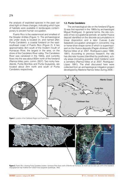
- Page 274 and 275: Of Shell and Sand: Coastal Habitat
- Page 278 and 279: 276 ISABEL C. RIVERA-COLLAZO Figure
- Page 280 and 281: 278 ISABEL C. RIVERA-COLLAZO BIVALV
- Page 282 and 283: 280 ISABEL C. RIVERA-COLLAZO GASTRO
- Page 284 and 285: 282 ISABEL C. RIVERA-COLLAZO clypea
- Page 286: 284 ISABEL C. RIVERA-COLLAZO RODRIG
- Page 289 and 290: MUNIBE(Suplemento/Gehigarria) - nº
- Page 291 and 292: Archaeological shell middens and sh
- Page 293 and 294: Archaeological shell middens and sh
- Page 295 and 296: Archaeological shell middens and sh
- Page 297 and 298: MUNIBE(Suplemento/Gehigarria) - nº
- Page 299 and 300: Molluscs as sedimentary components.
- Page 301 and 302: Molluscs as sedimentary components.
- Page 303 and 304: Molluscs as sedimentary components.
- Page 305 and 306: MUNIBE(Suplemento/Gehigarria) - nº
- Page 307 and 308: The U.S. Freshwater Shell Button In
- Page 309 and 310: The U.S. Freshwater Shell Button In
- Page 311: The U.S. Freshwater Shell Button In